geo.wikisort.org - Reservoir
Lake Thun (German: Thunersee) is an Alpine lake in the Bernese Oberland in Switzerland named after the city of Thun, on its northern shore. At 48.3 km2 (18.6 sq mi) in surface area, it is the largest Swiss lake entirely within a single canton.
| Lake Thun Thunersee | |
|---|---|
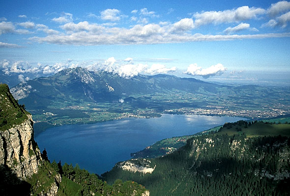 View with Thun from the Niederhorn | |
 Lake Thun Thunersee  Lake Thun Thunersee  Lake Thun Thunersee | |
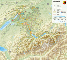
| Location | Canton of Berne |
| Coordinates | 46°41′N 7°43′E |
| Type | freshwater fjord, recent regulation[1] |
| Primary inflows | Aare Kander |
| Primary outflows | Aare |
| Catchment area | 2,500 km2 (970 sq mi) |
| Basin countries | Switzerland |
| Max. length | 17.5 km (10.9 mi) |
| Max. width | 3.5 km (2.2 mi) |
| Surface area | 48.3 km2 (18.6 sq mi) |
| Average depth | 136 m (446 ft) |
| Max. depth | 217 m (712 ft) |
| Water volume | 6.5 km3 (5,300,000 acre⋅ft) |
| Residence time | 684 days |
| Surface elevation | 558 m (1,831 ft) |
| Settlements | Thun, Spiez, Faulensee |
 | |
The lake was created after the last glacial period. After the 10th century, it split from Lake Brienz, before which the two lakes were combined, as Wendelsee ("Lake Wendel").[2] The culminating point of the lake's drainage basin is the Finsteraarhorn at 4,274 metres (14,022 ft) above sea level.[3]
Lake Thun's approximate 2,500 square kilometres (970 sq mi) catchment area frequently causes local flooding after heavy rainfalls. This occurs because the river Aare (German: Aare), which drains Lake Thun, has only limited capacity to handle the excess runoff. The lake is fed by water from Lake Brienz to the southeast, which is 6 metres (20 ft) higher than Lake Thun, and various streams in the Oberland, including the Kander.
In 1835, passenger steamships began operating regularly on the lake. Ten passenger ships, operated by the local railway company BLS AG like Blümlisalp, serve the towns of Interlaken and Thun; the Interlaken ship canal and Thun ship canal connect the lake to Interlaken West railway station and Thun railway station respectively.[4][5]
Following World War II and up until 1964, the Swiss Government disposed of unused munitions into Lake Thun. The quantity of munitions dumped is reported to be from 3,000 to more than 9,020 tons.[6][7]


References
- Kanton Bern, Wasser- und Energiewirtschaftsamt (Water and Energy Department): Möglichkeiten und Grenzen der Seeregulierung am Thuner See (Possibilities and limits of regulating the Thunersee)[permanent dead link]
- www.spiez.ch: Schloss (Castle of) Spiez around 1000 AD called "Goldener Hof am Wendelsee" ("Golden Court on lake Wendel) Archived 2014-05-14 at the Wayback Machine
- 1:25,000 topographic map (Map). Swisstopo. Retrieved 2014-07-28.
- "History of navigation on Lakes Thun and Brienz". BLS AG. Retrieved 2012-12-13.
- "BLS Schiffahrt - Our fleet". BLS AG. Retrieved 2012-12-13.
- Foulkes, Imogen (August 28, 2003). "Fears over dumped munitions in Lake Thun". Retrieved March 19, 2010.
- Tagliabue, John (August 12, 2009). "A Turbulent Past Lurks in a Serene Swiss Lake". NYTimes.com. Retrieved Sep 13, 2009.
External links
 Media related to Lake Thun at Wikimedia Commons
- Lake Thun Tourism Portal
- The River Aare sluices
Lakes of Switzerland | ||
|---|---|---|
| Major lakes |
|  |
| Lists | ||
Authority control | |
|---|---|
| General |
|
| National libraries | |
| Other | |
На других языках
[de] Thunersee
Der Thunersee ist ein Fjordsee im Berner Oberland am nördlichen Alpenrand. Der See ist 17,5 km lang und max. 3,5 km breit. Seine Fläche beträgt 47,85 km²;[2] damit ist er der grösste nur in einem Kanton liegende See der Schweiz. Die maximale Tiefe beträgt 217 m.- [en] Lake Thun
[fr] Lac de Thoune
Le lac de Thoune (Thunersee en allemand) est un lac alpin situé dans l'Oberland bernois en Suisse. Son nom lui vient de la ville de Thoune.[it] Lago di Thun
Il lago di Thun (tedesco Thunersee) è un lago del Canton Berna, in Svizzera, che prende nome dall'omonima città. È un lago naturale formato dal fiume Aar appena dopo il lago di Brienz. Si formò in occasione dell'ultima glaciazione. Originariamente era unito al lago di Brienz. Il lago completo (Thun e Brienz) era chiamato "lago di Wendel" (in lingua tedesca Wendelsee). Si affacciano sul lago comuni appartenenti a quattro distretti:[ru] Тунское озеро
Ту́нское о́зеро[4][5][1][6] (Тунер-Зе[2]; нем. Thunersee[1], Thuner See[6]) — озеро в швейцарском кантоне Берн, располагается на высоте 558 м над уровнем моря; площадь 47,88 км², глубина до 217 м[1], длина 17,5 км, ширина до 3,5 км[3].Другой контент может иметь иную лицензию. Перед использованием материалов сайта WikiSort.org внимательно изучите правила лицензирования конкретных элементов наполнения сайта.
WikiSort.org - проект по пересортировке и дополнению контента Википедии