geo.wikisort.org - Reservoir
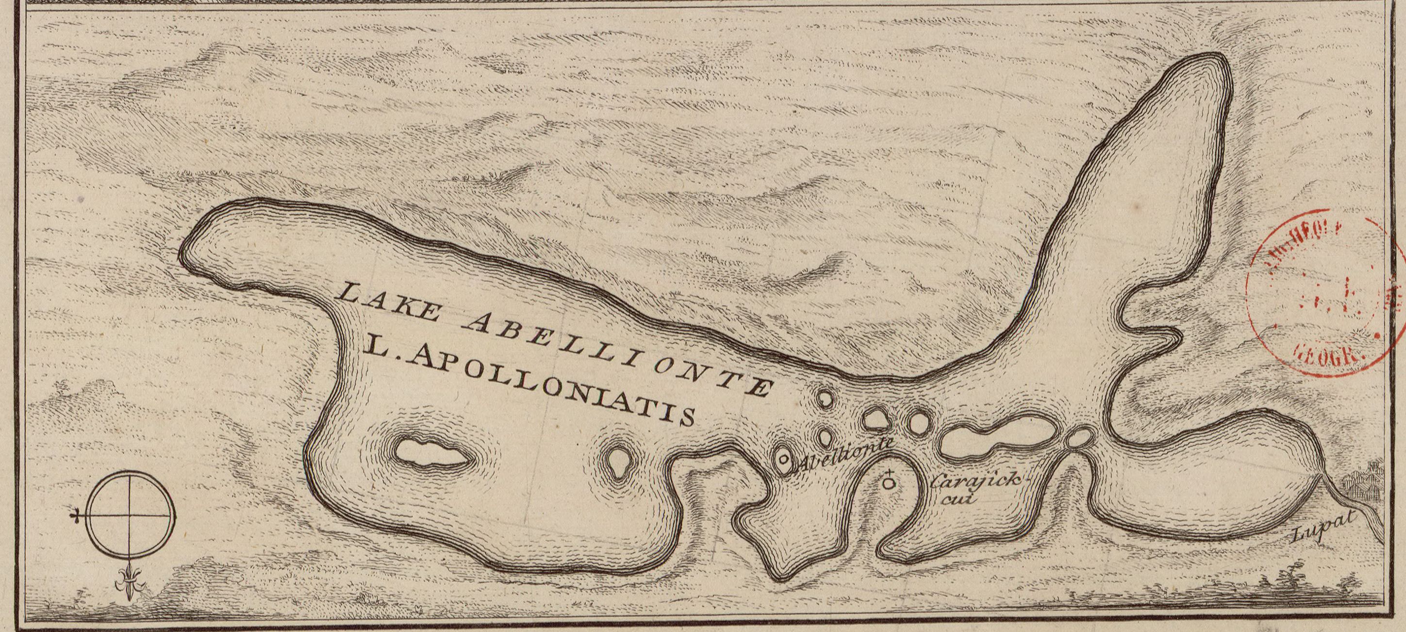
Lake Uluabat (Turkish: Uluabat Gölü and Apolyont Gölü) is the name of a freshwater lake in the vicinity of Bursa, Turkey. It is a large lake, covering an area of between 135 and 160 km2 depending on the water level, but very shallow, being only 3 m deep at its deepest point. The lake contains eight islands and one other that is sometimes an island and sometimes a peninsula. The largest island is known as Halilbey Island. In the southwest the lake is fed by the Mustafakemalpaşa River, which has formed a silty delta. Water leaves the lake by way of the Ulubat stream, flowing to the west, and reaches the Sea of Marmara via the Susurluk River.[2]
This article needs additional citations for verification. (December 2009) |
| Lake Uluabat | |
|---|---|
 Lake Uluabat | |
 Lake Uluabat | |
| Coordinates | 40°10′N 28°35′E |
| Primary inflows | Mustafakemalpaşa River |
| Primary outflows | Ulubat stream |
| Basin countries | Turkey |
| Surface area | 135 to 160 km2 (52 to 62 sq mi) |
| Max. depth | 10 m (33 ft) |
| Islands | 8 (Halilbey Island) |
| Settlements | Gölyazı |
Ramsar Wetland | |
| Designated | 12 June 1998 |
| Reference no. | 944[1] |


Most shores of the lake are covered in submerged plants, and it has the most extensive white water lily beds in Turkey. Uluabat Lake is one of the breeding areas for the endangered pygmy cormorant (Phalacrocorax pygmeus). The latest DHKD (Society for the Protection of Nature Turkey) survey in June 1998 found 823 pygmy cormorant pairs, 105 night heron pairs, 109 squacco heron pairs, and 48 spoonbill pairs breeding on Uluabat.
The alternative name Lake Apolyont comes from the lake's greek classical name Apolloniatis (Απολλωνιάτις), from Apollonia-on-the-Rhyndacum (modern Gölyazı), an ancient Greek city situated on its banks which had considerable importance since it was on major trade routes.
Modern residential areas by its shores are Mustafakemalpaşa (formerly Kirmasti) and Karacabey (formerly Mikalick). The area was famous for centuries for its silkworm cultivation, but this industry has died out due to synthetic fabrics. The main industry today is fishing.
History
Overview
Uluabat Lake was recognized by the Ramsar Convention on Wetlands of International Importance.[3][4] The Global Nature Fund designated the lake as a "Living Lake" in 1998.[3][4]
Hydrology
Lake Uluabat empties into the Sea of Marmara via the Susurluk River. The Lake is fed by the Mustafakemalpaşa River.[2]
Ecology

Lake Uluabat is a large, long, shallow inland lake that is surrounded by marshes and agricultural land.[5] There are submerged plants on the shores of the lake. According to the Global Nature Fund, there is nowhere in Turkey with more white water lily beds than Lake Uluabat.[3]
Islands and peninsulas
There are seven islands in the lake, including Halilbey Island.[2]—which is the largest island, and St. Constantine—known for the Byzantine era monastery. Today St. Constantine island is uninhabited, but the monastery has survived the Ottoman conquest of Asia Minor. The orthodox monastery has received attention from scholars because of its inscribed cross type with apses east and west.[6]
One of the most well-known features of Lake Uluabat is the small island village of Gölyazı—an ancient Greek settlement near modern day Bursa.[4] Gölyazı was featured in the final episode of the Turkish TV series Kara Para Aşk.[4][7] The Gölyazı Old Mosque, located on the peninsula is a UNESCO World Heritage Site.[8]
Wildlife
The lake, which has an "Unprotected Status" (UP), was declared by BirdLife International as an Important Bird Area in 1989 for its waterfowl species of international character and species which are globally threatened.[5][2] Uluabat Lake is one of the breeding areas for the endangered pygmy cormorant (Phalacrocorax pygmeus). The latest DHKD (Society for the Protection of Nature Turkey) survey in June 1998 found 823 pygmy cormorant pairs, 105 night heron pairs, 109 squacco heron pairs, and 48 spoonbill pairs breeding on Uluabat.[5]
There are 21 species of fish in Lake Uluabat.[2]
See also
- Uluabat
- Lake Akşehir
References
- "Lake Uluabat". Ramsar Sites Information Service. Retrieved 25 April 2018.
- Fathalla, Waled (February 14, 2019). "Uluabat Lake". Retrieved April 29, 2021.
- "Lake Uluabat". Global Nature (GNF). Retrieved April 29, 2021.
- Dennis (May 7, 2016). "Uluabat Lake". The Best of Bursa. Retrieved April 29, 2021.
- Grimmett, R. F. A.; Kasparek, Max; Kılıç, A.; Ertan I, A. "Important Bird Areas In Turkey: Unprotected And Under Threat" (PDF). Retrieved April 29, 2014. This paper was "adapted from a talk given at the XVII ICBP European Continental Section Conference held in Adana, Turkey from May 15 to May 20, 1989.
- Mango, Cyril (1979), The Monastery of St. Constantine on Lake Apolyont, Dumbarton Oaks Papers, vol. 33, pp. 329–333
- Black Money Love (TV Series 2014–2015). IMDb. FAQ. Retrieved April 29, 2021.
- "Gölyazı Old Mosque". Tourism and Promotion Bursa Turizm Portalı, Bursa Department of International Affairs. Retrieved April 29, 2021.
| Natural lakes |
|
|---|---|
| Artificial lakes | |
| |
| Authority control |
|
|---|
На других языках
[de] Uluabat Gölü
Der Uluabat Gölü, auch Apolyont Gölü, ist ein Gewässer in den Weiten der Provinz Bursa in der Marmararegion. Der große See bedeckt je nach Wasserstand eine Fläche von 135 bis 160 km², ist aber bei einer durchschnittlichen Tiefe von drei Metern ein flacher See. Der grob dreieckige See hat eine West-Ost-Ausdehnung von 23–24 km und ist von Nord nach Süd 12 km lang. Der See entstand durch tektonische Senkungen in der Region.- [en] Lake Uluabat
[it] Lago di Uluabat
Il lago di Uluabat (in turco: Uluabat Gölü, anche Apolyont Gölü), è un lago della provincia di Bursa nella regione di Marmara. A seconda del livello dell'acqua, il grande lago copre un'area di 135-160 km², ma avendo una profondità media di tre metri è un lago poco profondo. Lo specchio d'acqua è grossolanamente triangolare e ha un'estensione ovest-est di 23-24 km e nord-sud di 12 km. Il bacino si è formato attraverso cedimenti tettonici avvenuti nella regione.[ru] Улубат
Улубат[1][2][3] (тур. Uluabat Gölü, Апольонт[2], Apolyont Gölü) — озеро в Турции, к востоку от города Караджабей в иле Бурса. В озеро впадает река Мустафакемальпаша, вытекает — Улуабад, приток реки Симав, на котором находится село Улуабад. Принадлежит бассейну Мраморного моря.Другой контент может иметь иную лицензию. Перед использованием материалов сайта WikiSort.org внимательно изучите правила лицензирования конкретных элементов наполнения сайта.
WikiSort.org - проект по пересортировке и дополнению контента Википедии