 Lake Salda
 Microbialites in Lake Salda rocks
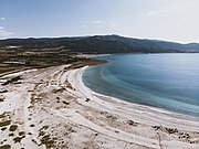 Coast of the Lake Salda
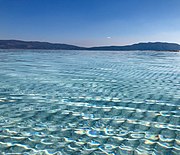
 Coast of the Lake Salda declared a natural reserve after some environmental concerns.
geo.wikisort.org - Reservoir
Lake Salda, also known as "the Maldives of Turkey" (Turkish: Türkiye'nin Maldivler'i), is a mid-size crater lake[2] in southwestern Turkey, within the boundaries of Yeşilova district of Burdur Province. It lies at a distance of about fifty kilometers to the west from the province seat Burdur.
| Lake Salda | |
|---|---|
 Lake Salda in June 2020 | |
 Lake Salda | |
| Coordinates | 37°33′N 29°41′E |
| Basin countries | Turkey |
| Surface area | 43.70 km2 (16.87 sq mi) |
| Max. depth | 196 m (643 ft) |
| Surface elevation | 1,316 m (4,318 ft)[1] |
| Settlements | Salda |
Lake Salda is often included in the Turkish Lakes Region that extends across inner western to southern Anatolia, especially Isparta Province and Afyonkarahisar Province, although Lake Salda is geographically separate from the larger lakes, which are more to the east and, being a crater lake, is morphologically different from these tectonic lakes.
The lake area covers 4,370 hectares, and its depth reaches 196 meters, making it one of the deeper lakes in Turkey, if not the deepest. The lake sedimentary records show high resolution climate changes that are related to solar variability during the last millennium.[3]
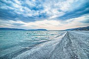
The lake is a popular excursion spot for people across the region or from beyond, the more so due to the hydromagnesite mineral found in its coastal waters, which is believed to offer remedies for certain dermatological diseases. The shorelines, surrounded by black pine forests, are also popular among hunters, the game and the fowl available including quails, hares, foxes, boars and wild ducks, aside from the lake's fish. White sandy beaches, limpid water and seven crystal-white islets within the lake complete the scenery.
A township that starts almost at the shore to the southwest of the lake carries the same name, Salda. The local administrative seat of Yeşilova is located to the east of the lake at a distance of about four kilometers and Yeşilova municipality manages the lake's camping facilities.
Its peculiar morphology has led to a number of academic studies conducted on Lake Salda. The unusual alkaline nature of the lake means that is one of the few locations where ancient stromatolite algae still grows.[4]
In 2019, a team of planetary scientists from America and Turkey conducted research on Lake Salda's shoreline microbialite sediments. In March 2021, NASA reported that its Mars surface-exploring rover Perseverance showed that "the minerals and rock deposits at Salda are the nearest match on earth to those around the Jezero Crater where the spacecraft landed."[5]
Hoping to protect the Lake Salda area, the nation's environmental authority has launched a huge national park project. The Salda Lake National Park is currently under construction and should be finished in 2023.
A 24 hour livestream of the lake can be seen on its official website. [6]
Gallery


References
- "Salda Gölü". Orman ve Su İşleri Bakanlığı. Retrieved 29 September 2018.
- "Salda Lake – Antalya: All You Need To Know | Things to do Antalya". www.thingstodoantalya.com. Retrieved 2022-06-02.
- Danladi, I. B., & Akçer-Ön, S. (2017). Solar forcing and climate variability during the past millennium as recorded in a high altitude lake: Lake Salda (SW Anatolia). Quaternary International
- C. J. R. Braithwaite (University of Glasgow, Department of Geology and Applied Geology) – Veysel Zedef Selçuk University, Konya (September 1996). "Hydromagnesite stromatolites and sediments in an alkaline lake, Salda Golu, Turkey". Journal of Sedimentary Research – V. 66; no. 5; p. 991–1002.
{{cite web}}: CS1 maint: multiple names: authors list (link) - Dikmen, Yesim (9 March 2021). "Mars on Earth: Turkish lake may hold clues to ancient life on planet". Reuters. Retrieved 9 March 2021.
- "Salda Gölü #Canlı". Salda Gölü. Ministry of Environment, Urbanization and Climate Change.
| Natural lakes |
|
|---|---|
| Artificial lakes | |
| |
На других языках
- [en] Lake Salda
[fr] Lac de Salda
Le Lac de Salda ou Lac Salda (turc : Salda Gölü) est un lac de soude se situant dans le district de Yeşilova dans la province de Burdur en Turquie. Il est situé dans la région des lacs. Avec une superficie de 44 km2 et une profondeur de 184 m, c'est le deuxième lac plus profond de Turquie[1].[it] Lago di Salda
Il lago di Salda (in turco: Salda Gölü) è un lago craterico di medie dimensioni nella Turchia sud-occidentale, entro i confini del distretto di Yeşilova nella provincia di Burdur, e si trova a una distanza di circa cinquanta chilometri a ovest dalla sede provinciale di Burdur. Si estende su parte di un'area conosciuta come il Distretto dei laghi nell'Anatolia sudoccidentale.[ru] Салда (озеро)
Салда[1] (тур. Salda Gölü) — кратерное озеро на юго-западе Турции, в границе района Ешилова ила Бурдур. Площадь поверхности озера — 45 км²[2]. Длина озера — 8 км, ширина — 6 км[2]. Высота над уровнем моря — 1165 м[1], по другим данным — 1180 м[2]. Глубина достигает 200 метров[2].Текст в блоке "Читать" взят с сайта "Википедия" и доступен по лицензии Creative Commons Attribution-ShareAlike; в отдельных случаях могут действовать дополнительные условия.
Другой контент может иметь иную лицензию. Перед использованием материалов сайта WikiSort.org внимательно изучите правила лицензирования конкретных элементов наполнения сайта.
Другой контент может иметь иную лицензию. Перед использованием материалов сайта WikiSort.org внимательно изучите правила лицензирования конкретных элементов наполнения сайта.
2019-2026
WikiSort.org - проект по пересортировке и дополнению контента Википедии
WikiSort.org - проект по пересортировке и дополнению контента Википедии