geo.wikisort.org - Reservoir
Lake Tuz (Turkish: Tuz Gölü meaning 'Salt Lake'; anciently Tatta — Ancient Greek: ἡ Τάττα, Latin: Tatta Lacus) was the second largest lake in Turkey with its 1,665 km2 (643 sq mi) surface area and one of the largest hypersaline lakes in the world. It is located in the Central Anatolia Region, 105 km (65 mi) northeast of Konya, 150 km (93 mi) south-southeast of Ankara and 57 km (35 mi) northwest of Aksaray. In recent years, Lake Tuz has become a hotspot for tourists. In October 2021, Lake Tuz dried up completely.[1][2]
| Lake Tuz | |
|---|---|
| Τάττα Lacus | |
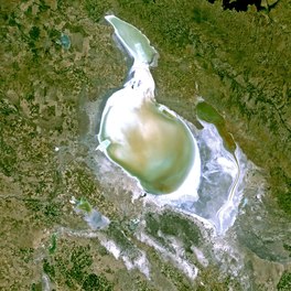 View from space | |
OpenStreetMap
{{{2}}} | |
 Lake Tuz | |
| Location | Central Anatolia |
| Coordinates | 38°44′N 33°23′E |
| Type | endorheic hypersaline |
| Primary inflows | Peçenek Çayı, Melendiz Çayı |
| Primary outflows | none |
| Catchment area | 11,900 km2 (4,600 sq mi) |
| Basin countries | Turkey |
| Max. length | 80 km (50 mi) |
| Max. width | 50 km (31 mi) |
| Surface area | 1,600 km2 (620 sq mi) |
| Average depth | 0.5 m (2 ft) |
| Max. depth | 1.5 m (5 ft) |
| Surface elevation | 905 m (2,969 ft) |
| Settlements | Şereflikoçhisar |
Geography

The lake, occupying a tectonic depression in the central plateau of Turkey, is fed by two major streams, groundwater, and surface water, but has no outlet. Brackish marshes have formed where channels and streams enter the lake. Arable fields surround the lake, except in the south and southwest where extensive seasonally flooded salt-steppe occurs.
For most of the year, it is very shallow (approx.0.4 m (1 ft)). During winter part of the salt is dissolved in the fresh water that is introduced to the lake by precipitation and surface runoff (to 324‰ salinity). During the summer the lake dries up exposing an average of 30 cm thick salt layer in August. This mechanism is used as a basis for the process of the salt mines in the lake. The three mines operating in the lake produce 63% of the salt consumed in Turkey. The salt mining generates industrial activity in the region, mainly related to salt processing and refining.
Geology
Formation
Subsidence in the Tuz Gölü Lower Basin occurred during the Upper Senonian-Lower Middle Eocene and was followed by a regression that started in the upper Eocene and continued until the end of the Oligocene. During the Upper Senonian-Lower Middle Eocene, the Tuz Gölü Lower Basin formed a single and continuous depression towards the north with the Haymana region. The Haymana Basin, which rose after the deposition of the Middle Eocene Nummulitic limestones, separated the Tuz Gölü Basin with a fault zone along the eastern edge of the Karacadağ uplift.[3]
The connection of Tuz Gölü with the north-northeast Çankırı basin occurred during the Pliocene period and continued throughout the Middle Eocene-Oligocene, when the lake basin became a graben bounded by the north-west and north-east fault zones. After the main deformation in the late Oligocene or Miocene period, local depositional basins were formed during the Neogene period, and volcanics of varying thickness and terrestrial sediments including lake limestones were deposited in these basins. The Tuz Gölü Basin has been little affected by the recent Alpine compressional movements in the Pliocene. Tension movements that took place in the Neogene and continued until the Pliocene caused volcanic activities dating back to historical times.[3]
Geological structure
It can be said that Tuz Gölü has a unique geological structure. In the geological structure of the lake, there is a salt layer of different densities that continues continuously for 1,000 meters. This layer ensures the continuity of salt production around the lake, in other words, it extends the commercial life of the salt industry in the region.
In the Tuz Gölü Basin, there is a 10 km-thick stacking with age varying from the Upper Cretaceous to the present. While units such as shale, sandstone, pebble stone and limestone, which generally have flysch character and interact with each other in vertical and lateral directions, were deposited in the deep parts of the basin, it was revealed by the researchers that terrestrial and shallow marine units in the marginal parts were also deposited.
Conglomerate and sandstones, which are high energy products, were deposited in shallow marine and terrestrial environments, and shale, limestone, gypsum and anhydrites were formed in calm periods. The basement rock units, Temirözü, Mollaresul formations, Ankara complex and Kırşehir crystalline complex in the north and northeast of the Tuz Gölü Basin, and low-grade metamorphics in the west and southwest constitute.[3]
Climate


The basin of Lake Tuz is influenced by cold semi-arid steppe (Bsk) and Mediterranean (Csa and Csb) climates. Northern areas of the basin such as Kulu are wetter and show a Mediterranean characteristic, meanwhile more southern areas like Çumra, Aksaray and Karapınar have a steppe climate. The area is generally sheltered from moisture-bearing air masses behind the Taurus Mountains. The average yearly precipitation in the basin is 324 mm, thus making the region one of the driest in Turkey.[4][5]
| Climate data for Şereflikoçhisar (northeastern shore) | |||||||||||||
|---|---|---|---|---|---|---|---|---|---|---|---|---|---|
| Month | Jan | Feb | Mar | Apr | May | Jun | Jul | Aug | Sep | Oct | Nov | Dec | Year |
| Average high °C (°F) | 3.7 (38.7) |
6.5 (43.7) |
11.4 (52.5) |
16.8 (62.2) |
21.3 (70.3) |
25.8 (78.4) |
29.3 (84.7) |
29.1 (84.4) |
25.5 (77.9) |
19.1 (66.4) |
12.3 (54.1) |
6 (43) |
17.2 (63.0) |
| Daily mean °C (°F) | −0.2 (31.6) |
1.9 (35.4) |
5.8 (42.4) |
10.6 (51.1) |
14.7 (58.5) |
18.6 (65.5) |
21.9 (71.4) |
21.5 (70.7) |
17.9 (64.2) |
12.4 (54.3) |
6.7 (44.1) |
2.1 (35.8) |
11.2 (52.1) |
| Average low °C (°F) | −4.1 (24.6) |
−2.8 (27.0) |
.1 (32.2) |
4.4 (39.9) |
8.1 (46.6) |
11.4 (52.5) |
14.4 (57.9) |
13.9 (57.0) |
10.2 (50.4) |
5.6 (42.1) |
1.1 (34.0) |
−1.8 (28.8) |
5.0 (41.1) |
| Average precipitation mm (inches) | 55 (2.2) |
47 (1.9) |
49 (1.9) |
52 (2.0) |
48 (1.9) |
22 (0.9) |
6 (0.2) |
4 (0.2) |
10 (0.4) |
25 (1.0) |
40 (1.6) |
62 (2.4) |
420 (16.6) |
| Source: [6] | |||||||||||||
History

Anciently, the lake was called Tatta, and was located on the frontiers between ancient Lycaonia and Galatia; it had originally belonged to Phrygia, but was afterwards annexed to Lycaonia. The ancients reported that its waters were so impregnated with brine, that any substance dipped into it, was immediately encrusted with a thick coat of salt; even birds flying near the surface had their wings moistened with the saline particles, so as to become incapable of rising into the air, and to be easily caught.[7][8][9] Stephanus of Byzantium speaks of a salt lake in Phrygia, which he calls Attaea (Ἄτταια), near which there was a town called Botieum, and which is probably the same as Lake Tatta.[10]
Pre-history
Pre-historical Lake Tatta was originally a much larger freshwater lake with numerous rivers flowing in and out of it, that dominated the Central Anatolian interior. Lush with vegetation, the region sprung up some of the earliest known civilizations including the Hittites and Anatolian people. After the last Ice age between 11,000 and 5,000 years ago, the Central Anatolian steppe began to gradually transform into its current form.
Flora and fauna


In 2001, Lake Tuz was declared a specially protected area, including all of the lake surface and surrounding waterbeds and some of the important neighboring steppe areas. The main Turkish breeding colony of greater flamingo (Phoenicopterus roseus) is present on a group of islands in the southern part of the lake. Greater white-fronted goose (Anser albifrons) is the second largest breeder here. Lesser kestrel (Falco naumanni) is a common breeder in surrounding villages.[citation needed]
Gallery
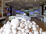 A gift shop near Lake Tuz
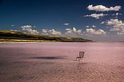 Empty chair at Lake Tuz
 Lake Tuz at Sunset
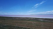 Lake Tuz seen from the road
 Tourists visiting Lake Tuz
 In the summer, the salt lake is transformed into a salt flat or playa.


See also
References
- Guzel, Mehmet; Fraser, Suzan (28 October 2021). "Turkey's Lake Tuz dries up due to climate change, farming". AP News.
- Kathryn Hansen: Disappearing Lake Tuz: Large Lake Is Now Just a Puddle. SciTechDaily, 16 December 2021. Source: NASA Earth Observatory.
- "Archived copy" (PDF). Archived from the original (PDF) on 22 July 2016. Retrieved 23 December 2015.
{{cite web}}: CS1 maint: archived copy as title (link) - "Alanin Tanimlanmasi Ve Analızı" (PDF). Çevre Ve Şehırcılık Bakanliği. Archived from the original (PDF) on 22 July 2016. Retrieved 29 October 2016.
- Akin, Burcu (2019). "Tuz Gölü Havzası'nın Kuraklık Analizi". Ulusal Çevre Bilimleri Araştırma Dergisi (in Turkish). Retrieved 2021-07-29.
{{cite web}}: CS1 maint: url-status (link) - "Şereflikoçhisar - Weather History & Climate Data - Meteostat". meteostat.net. Retrieved 2021-06-04.
- Strabo. Geographica. Vol. xii. p.568. Page numbers refer to those of Isaac Casaubon's edition.
- Pliny. Naturalis Historia. Vol. 31.41, 31.45.
- Dioscorid. 5.126.
- Stephanus of Byzantium. Ethnica. Vol. s.v. Βοτίειον.
- "Archived copy" (PDF). 22 July 2016. Retrieved 23 December 2015.
![]() This article incorporates text from a publication now in the public domain: Smith, William, ed. (1854–1857). "Tatta Lacus". Dictionary of Greek and Roman Geography. London: John Murray.
This article incorporates text from a publication now in the public domain: Smith, William, ed. (1854–1857). "Tatta Lacus". Dictionary of Greek and Roman Geography. London: John Murray.
External links
 Media related to Lake Tuz at Wikimedia Commons
| Natural lakes |
|
|---|---|
| Artificial lakes | |
| |
UNESCO Tentative list of World Heritage Sites in Turkey | |
|---|---|
| Aegean Region |
|
| Black Sea Region |
|
| Central Anatolia Region |
|
| Eastern Anatolia Region |
|
| Marmara Region |
|
| Mediterranean Region |
|
| Southeastern Anatolia Region |
|
| Country-wide |
|
| |
| Authority control: National libraries |
|---|
На других языках
[de] Tuz Gölü
Der Tuz Gölü (türkisch für „Salzsee“, in der Antike lat. als Lacus Tatta bekannt) ist ein Salzsee in der Türkei und nach dem Vansee der zweitgrößte See des Landes. Mit 32,9 % Salzanteil ist er einer der salzhaltigsten Seen der Welt.- [en] Lake Tuz
[es] Lago Tuz
El lago Tuz (en turco, Tuz Gölü, que significa «lago de sal») es el segundo mayor lago de Turquía, y se encuentra en la región de Anatolia Central, 105 km al noreste de Konya y 150 km al sureste de Ankara. Durante la mayor parte del año, este lago salino y poco profundo cubre un área de 1.500 km². Normalmente tiene 80 km de longitud y 50 km de ancho, con una elevación de 905 msnm. El área que cubre es compartida por las provincias turcas de Ankara, Konya y Aksaray, con una población de alrededor de 3 millones de personas.[fr] Lac Tuz
Le lac Tuz (en turc : Tuz Gölü, « lac de sel ») est le second plus grand lac de Turquie, situé en Anatolie centrale, à 105 km au nord-est de Konya et à 150 km au sud-est d'Ankara.[it] Lago Salato (Turchia)
Il Lago Salato (in turco: Tuz Gölü) è il secondo lago per ampiezza in Turchia, situato nell'Anatolia centrale, 105 km a nord-est da Iconio e 150 km Sud-Est da Ankara. Per gran parte dell'anno questo lago basso (1-2 metri) e salato ha un'area di 1.500 km². Normalmente è lungo 80 km e largo 50 ad un'altezza di 905 m s.l.m. La sua area è divisa fra le province di Ankara, Konya e Aksaray. Presso il lago vivono oltre 3 milioni di persone.[ru] Туз (озеро)
Туз[1] (тур. Tuz Gölü, букв. Солёное озеро; в древности — др.-греч. Τάττα; Λιμνοθάλασσα εν Φρυγίη — «Фригийское солёное озеро») — второе по величине озеро в Турции. Солёность озера составляет 340 ‰. Расположено в центре полуострова Анатолия, в 105 км к северо-востоку от Коньи и в 150 км к юго-востоку от Анкары.Другой контент может иметь иную лицензию. Перед использованием материалов сайта WikiSort.org внимательно изучите правила лицензирования конкретных элементов наполнения сайта.
WikiSort.org - проект по пересортировке и дополнению контента Википедии