geo.wikisort.org - Mountains
Slalok Mountain, originally known as Rex's Pillar, is a 2,653-metre (8,704-foot) mountain summit located in the Coast Mountains, in Joffre Lakes Provincial Park, in southwestern British Columbia, Canada. It is the third-highest point of the Joffre Group, which is a subset of the Lillooet Ranges.[3] It is situated 24 km (15 mi) east of Pemberton, and 8 km (5 mi) northeast of Lillooet Lake. Its nearest higher peak is Mount Matier, 1.9 km (1 mi) to the east.[3] Precipitation runoff from the peak drains into Joffre Creek and Twin One Creek, both tributaries of the Lillooet River. The first ascent of the mountain was made in 1963 by C. Adam, T. Anderson, and G. Richardson.[1] The mountain's name Slalok is the traditional name for the settlement of nearby Mount Currie.[4] The name was officially adopted on June 11, 1979, by the Geographical Names Board of Canada.[2] The mountain and its climate supports the Matier Glacier, Stonecrop Glacier, and Tszil Glacier on the northern slopes.
| Slalok Mountain | |
|---|---|
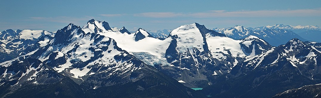
 Slalok Mountain, north aspect, featuring left to right the Matier, Stonecrop, and Tszil Glaciers and Upper Joffre Lake below | |
| Highest point | |
| Elevation | 2,653 m (8,704 ft)[1] |
| Prominence | 333 m (1,093 ft)[1] |
| Parent peak | Mount Matier (2783 m)[1] |
| Listing | Mountains of British Columbia |
| Coordinates | 50°19′39″N 122°28′24″W[2] |
| Geography | |
 Slalok Mountain Location in British Columbia  Slalok Mountain Slalok Mountain (Canada) | |
| Country | Canada |
| Province | British Columbia |
| District | Lillooet Land District |
| Protected area | Joffre Lakes Provincial Park |
| Parent range | Joffre Group Lillooet Ranges Coast Ranges |
| Topo map | NTS 92J8 Duffey Lake[2] |
| Climbing | |
| First ascent | 1963 C. Adam, T. Anderson, G. Richardson |
| Easiest route | Scramble, glacier travel |
Climate
Based on the Köppen climate classification, Slalok Mountain is located in a subarctic climate zone of western North America.[5] Most weather fronts originate in the Pacific Ocean, and travel east toward the Coast Mountains where they are forced upward by the range (Orographic lift), causing them to drop their moisture in the form of rain or snowfall. As a result, the Coast Mountains experience high precipitation, especially during the winter months in the form of snowfall. Temperatures can drop below −20 °C with wind chill factors below −30 °C. The months July through September offer the most favorable weather for climbing Slalok Mountain.
Climbing Routes
Established climbing routes on Slalok Mountain:[1]
- Southwest Ridge - class 3
- Matier Glacier - Ski ascent
- Northeast Ridge
- North Face (Stonecrop Glacier)
References
- "Slalok Mountain". Bivouac.com. Retrieved 2019-11-08.
- "Slalok Mountain". Geographical Names Data Base. Natural Resources Canada. Retrieved 2019-11-08.
- "Slalok Mountain, British Columbia". Peakbagger.com. Retrieved 2019-11-08.
- "Slalok Mountain". BC Geographical Names.
- Peel, M. C.; Finlayson, B. L.; McMahon, T. A. (2007). "Updated world map of the Köppen−Geiger climate classification". Hydrol. Earth Syst. Sci. 11. ISSN 1027-5606.
Gallery
 The Joffre Group: Joffre Peak (left), Mt. Matier (highest), Hartzell, Spetch, Slalok Mountain, Tszil, and Taylor (farthest right)
 Slalok Mountain from middle Joffre Lake
 Mt. Matier and Matier Glacier (left), Slalok (right)


See also
- Geography of British Columbia
- Geology of British Columbia
External links
- Weather forecast: Slalok Mountain
- Climbing Slalok Mountain: YouTube
Другой контент может иметь иную лицензию. Перед использованием материалов сайта WikiSort.org внимательно изучите правила лицензирования конкретных элементов наполнения сайта.
WikiSort.org - проект по пересортировке и дополнению контента Википедии