geo.wikisort.org - Mountains
Mount Frederick William is a mountain located at the Queen Reach arm of the Jervis Inlet within the Pacific Ranges of the Coast Mountains in British Columbia Canada. The mountain was named during the 1860 survey by HMS Plumper which charted all of the area and named the mountain after then-Prussian Crown Prince Frederick William, who had married Princess Victoria, the eldest child of Queen Victoria and Prince Albert.[1]
| Mount Frederick William | |
|---|---|
 Mt. Frederick William | |
| Highest point | |
| Elevation | 1,818 m (5,965 ft) |
| Prominence | W. of N. end of Princess Royal Reach, New Westminster Land District |
| Coordinates | 50°04′58.3″N 123°52′01.3″W |
| Geography | |
 Mount Frederick William Location in British Columbia | |
| Location | Jervis Inlet , British Columbia, Canada |
| District | New Westminster Land District |
| Parent range | Pacific Ranges |
| Topo map | NTS 92J4 Princess Louisa Inlet |
This mountain has been given the nickname of Frankenstein for it has the familiar profile of the famous monster's face.
External links
- "Frederick William, Mount". BC Geographical Names.
- CM_C2308 Fraser River to N.E.Pt. of Texada Island including Howe Sound and Jervis Inlet 'Annotated' 1863.02.16 1865.08[clarification needed]
Gallery
 Mt. Frederick William seen from Princess Louisa Inlet at Dusk.
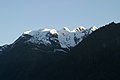 Mt. Frederick William close up
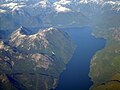 Behind Mt. Frederick William as seen from 20,000 feet (Bowl shape mountain)


References
- Hitz, Charles W.(2003). Through the Rapids - The History of Princess Louisa Inlet, p.54. Sikta 2 Publishing.,Kirkland, WA. ISBN 0-9720255-0-2.
This article about a location in British Columbia, Canada is a stub. You can help Wikipedia by expanding it. |
Текст в блоке "Читать" взят с сайта "Википедия" и доступен по лицензии Creative Commons Attribution-ShareAlike; в отдельных случаях могут действовать дополнительные условия.
Другой контент может иметь иную лицензию. Перед использованием материалов сайта WikiSort.org внимательно изучите правила лицензирования конкретных элементов наполнения сайта.
Другой контент может иметь иную лицензию. Перед использованием материалов сайта WikiSort.org внимательно изучите правила лицензирования конкретных элементов наполнения сайта.
2019-2026
WikiSort.org - проект по пересортировке и дополнению контента Википедии
WikiSort.org - проект по пересортировке и дополнению контента Википедии