geo.wikisort.org - Mountains
The Sarikol Range (Russian: Сарыкольский хребет; Chinese: 萨雷阔勒岭, 色勒库尔山脉; Tajik: Рашти Куҳи Сариқӯл) is a mountain range in the Pamirs on the border of Tajikistan and the People's Republic of China.
| Sarikol Range Сарыкольский хребет Рашти Куҳи Сариқӯл 萨雷阔勒岭 | |
|---|---|
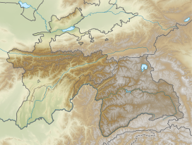
 Location in Tajikistan | |
| Highest point | |
| Peak | Mount Lyavirdyr |
| Elevation | 6,351 m (20,837 ft) |
| Coordinates | 38°38′N 74°30′E |
| Dimensions | |
| Length | 350 km (220 mi) N/S |
| Width | 35 km (22 mi) E/W |
| Geography | |
| Country | Tajikistan / China |
| Parent range | Pamir Mountains |
| Geology | |
| Age of rock | Paleozoic |
| Type of rock | Granite, schist and gneiss |
The name Sarikol has also been used to describe the local people who are historically known as Sarikolis; the local Sarikoli language and Tashkurgan Town, which was historically known as Sarikol.
Geography
The range divides Tajikistan's Gorno-Badakhshan Autonomous Province and China's Xinjiang Uyghur Autonomous Region and it runs parallel with the Muztagh Range to the east. The range extends 346 kilometres (215 mi) from the Markansu River in the north to the Beyik Pass in the south. Its average elevation is roughly 5,000 metres (16,500 ft) and the highest point in the range is Mount Lyavirdyr at 6,351 m (20,837 ft). On the Tajik part of the range there are 240 glaciers with a total area of 144 km2.[1] The range's drainage basin feeds both the Amu Darya and Tarim River. The range is composed of schist, granite and gneiss.[2]
See also
- List of mountains in Tajikistan
- China–Tajikistan border
References
- Сарыкольский хребет - article from the Great Soviet Encyclopedia
- "Sarykol Range", Encyclopædia Britannica, 2010-04-17
На других языках
[de] Sarikolkette
Die Sarikolkette (russisch Сарыко́льский хребе́т;tadschikisch Раште Кух Сарикол) ist ein Gebirgszug im östlichen Pamir entlang der Grenze zwischen Tadschikistan und der Volksrepublik China.- [en] Sarikol Range
[es] Cordillera Sarikol
La cordillera Sarikol (en chino simplificado, 色勒库尔山脉; pinyin, Sèlēikùěr Shānmài; (en ruso: Раште Кух Сарикол); (en persa: رشته کوه سريكال), Rashte Kuh Sarikol) es una cadena montañosa del Pamir, localizada en la frontera de Tayikistán y la República Popular China.[fr] Chaînon Sarikol
Le chaînon Sarikol est un massif montagneux situé entre le Tadjikistan, la République populaire de Chine et l'Afghanistan, dans le Pamir. Il culmine à 6 351 mètres d'altitude au pic Lyavirdyr.[it] Monti del Sarykol
I monti del Sarykol (nome kirghiso del fiume Taškurgan; in russo: Сарыко́льский хребе́т?; in tagico: Раште Кух Сарикол?) sono una catena montuosa del Pamir orientale situata lungo il confine tra il Tagikistan e la Cina.[ru] Сарыкольский хребет
Сарыко́льский хребе́т[1] (тадж. Раште Кух Сарикол, кит. 萨雷阔勒岭) — горный хребет в Восточном Памире, тянущийся вдоль границы Таджикистана и Китая. Тянется от долины реки Маркансу до отрогов Гиндукуша, огибая с севера котловину с озёрами Шоркуль и Рангкуль. Служит водоразделом бассейнов реки Тарим, озера Каракуль и Амударьи.Другой контент может иметь иную лицензию. Перед использованием материалов сайта WikiSort.org внимательно изучите правила лицензирования конкретных элементов наполнения сайта.
WikiSort.org - проект по пересортировке и дополнению контента Википедии
