geo.wikisort.org - Mountains
The Santa Monica Mountains is a coastal mountain range in Southern California, next to the Pacific Ocean. It is part of the Transverse Ranges.[1] Because of its proximity to densely populated regions, it is one of the most visited natural areas in California. The Santa Monica Mountains National Recreation Area encompasses this mountain range.
This article needs additional citations for verification. (December 2008) |
| Santa Monica Mountains | |
|---|---|
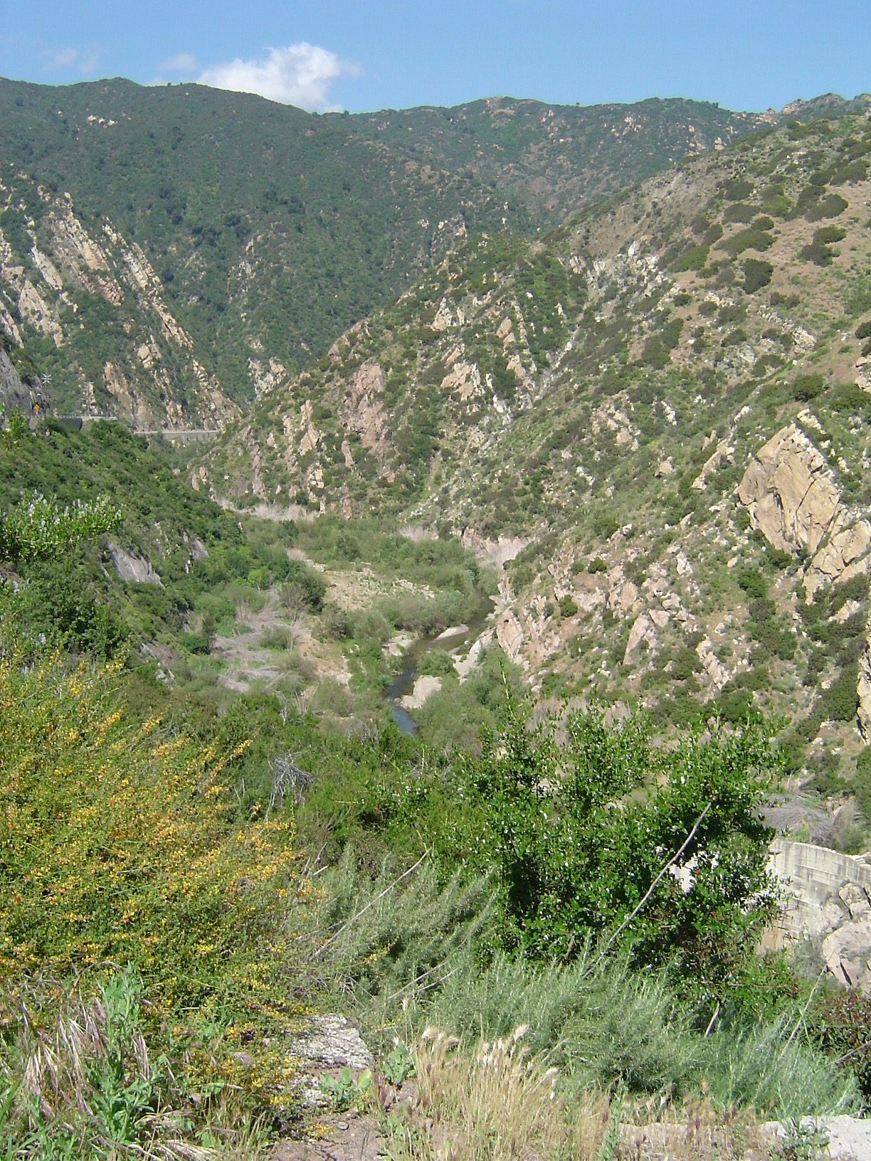 Malibu Canyon in the Santa Monica Mountains | |
| Highest point | |
| Peak | Sandstone Peak |
| Elevation | 3,111 ft (948 m) |
| Geography | |

| |
| Country | United States |
| State | California |
| Counties | Los Angeles and Ventura |
| Range coordinates | 34°7′13.023″N 118°55′54.348″W |
| Parent range | Transverse Ranges |
| Borders on | Santa Susana Mountains, Simi Hills and Verdugo Mountains |
Geography
The range extends approximately 40 miles (64 km) east-west from the Hollywood Hills in Los Angeles to Point Mugu in Ventura County. The western mountains, separating the Conejo Valley from Malibu, suddenly end at Mugu Peak[2] as the rugged, nearly impassible shoreline gives way to tidal lagoons and coastal sand dunes of the alluvial Oxnard Plain. The mountain range contributed to the isolation of this vast coastal plain before regular transportation routes reached western Ventura County. The eastern mountains form a barrier between the San Fernando Valley and the Los Angeles Basin, separating "the Valley" on the north and west-central Los Angeles on the south. The Santa Monica Mountains are parallel to the Santa Susana Mountains, which are located directly north of the mountains across the San Fernando Valley.
The range is of moderate height, with no particularly craggy or prominent peaks outside the Sandstone Peak and Boney Mountains area. While often rugged and wild, the range hosts a substantial amount of human activity and development. Houses, roads, businesses, and recreational centers are dotted throughout the Santa Monica Mountains.
A number of creeks in the Santa Monica Mountains are part of the Los Angeles River watershed. Beginning at the western end of the San Fernando Valley, the river runs to the north of the mountains. After passing between the range and the Verdugo Mountains it flows south around Elysian Park, defining the easternmost extent of the mountains.
Archeology
The Santa Monica Mountains have more than 1,000 archeology sites of significance, primarily from the Californian Native American cultures of the Tongva and Chumash people.[3] The mountains were part of their regional homelands for over eight thousand years before the arrival of the Spanish.[4] The Spanish mission system had a dramatic impact on their culture, and by 1831 their population had dropped from over 22,000 to under 3,000.[5]
Geology

Geologists consider the northern Channel Islands to be a westward extension of the Santa Monicas into the Pacific Ocean. The range was created by repeated episodes of uplifting and submergence by the Raymond Fault, which created complex layers of sedimentary rock, some containing fossils of invertebrates and fish. Volcanic intrusions have been exposed, including the poorly named andesitic[6] "Sandstone Peak", which is the highest point in the range at 3,111 feet (948 m). Malibu Creek, which eroded its own channel while the mountains were slowly uplifted, bisects the mountain range.
Climate

The Santa Monica Mountains have dry summers with frequent coastal fog on the ocean (south) side of the range and rainy, cooler winters. In the summer, the climate is quite dry (except for the coastal fog), which makes the range prone to wildfires, especially during dry "Santa Ana" wind events.
Snow is unusual in the Santa Monica Mountains, since they are not as high as the nearby San Gabriel Mountains. The lower slopes of the range average between 15 to 20 inches (380 to 510 mm) of rain per year, while the higher slopes of the central and western Santa Monica Mountains average 22 to 27 inches (560 to 690 mm) of rain per year. The bulk of the rain falls between November and March. The higher rainfall in the central and western parts of the range results in more widespread woodlands (with oak, sycamore, walnut, bay laurel, alder and other trees) than the eastern part of the range, where trees are usually restricted to the stream courses.
On January 17, 2007, an unusually cold storm brought snow in the Santa Monica Mountains. The hills above Malibu picked up three inches (eight centimeters) of snow - the first measurable snow in fifty years. Snow was reported on Boney Peak in the winter of 2005; and in March 2006, snow also fell on the summit of the mountain. Snow also fell on the peak of Boney Peak in late December 2008. The latest recorded snowfall in the area was in February 2019, when an unusual amount of snowfall accumulated in low passes in the mountains. That storm system also brought rare snowfall to the Los Angeles area. Heavy graupel was recorded in Malibu Canyon on January 23, 2021. It accumulated as low as 400 feet in elevation.
Wildfire
In the Santa Monica Mountains, when the fuels, seasonal drought, wind, and terrain combine with an ignition, a major wildfire occurs. These fires are large, wind-driven canopy fires that consume the above ground vegetation and often cause major property damage and home losses.[7]
In 2018, the Woolsey Fire burned through 88% of the federal parkland resulting in trails being closed for months.[8] The fire, which was three times larger than the biggest fire ever before in the mountains, burned over 40% of the natural area in the Santa Monicas.[9] A restoration plan was developed to plant 100,000 trees, shrubs and grasses of 25 different species.[10]
Protected areas
![Boney Mountain is sacred to the Chumash people.[11][12][13]](http://upload.wikimedia.org/wikipedia/commons/c/cf/Boney_peak.jpg)
Much of the mountains are located within the Santa Monica Mountains National Recreation Area. Preservation of lands within the region are managed by the Santa Monica Mountains Conservancy, the National Park Service, the California State Parks, and County and Municipal agencies. The Santa Monica Mountains face pressure from local populations as a desirable residential area, and in the parks as a recreational retreat and wild place that's increasingly rare in urban Los Angeles. In 2014 the California Coastal Commission and the Los Angeles County Board of Supervisors approved the Santa Monica Mountains Local Coastal Program, a land-use plan that will distinguish between the private lands that need strict protection and property that could be developed in strict conformance with this detailed plan.[14]
Regional parks
Over twenty individual state and municipal parks are in the Santa Monica Mountains, including: Topanga State Park, Leo Carrillo State Park, Malibu Creek State Park, Point Mugu State Park, Will Rogers State Historic Park, Point Dume State Beach, Griffith Park, Marvin Braude Mulholland Gateway Park, Charmlee Wilderness Park,[15] Franklin Canyon Park, Runyon Canyon Park, King Gillette Ranch Park,[16] and Paramount Ranch Park.[17]
Satwiwa
The Satwiwa Native American Indian Culture Center in Newbury Park, California is located within the Santa Monica Mountains National Recreation Area. The area was purchased by the U.S. National Park Service in 1980.[18] The Rosewood Trail near Stagecoach Inn, which leads to Angel Vista is an access point in Newbury Park.
Griffith Park
At the eastern end of the Santa Monica Mountains are Griffith Park and Elysian Park. Griffith Park is separated from the rest of the Santa Monica Mountains to the west by the Cahuenga Pass, over which the 101 Freeway (also called the Hollywood Freeway) passes from the San Fernando Valley into Hollywood. Elysian Park is in the easternmost part of the mountains and is bordered by the Los Angeles River to the east and Downtown Los Angeles nearby to the south.
Rim of the Valley Trail
The Rim of the Valley Trail is a plan in progress for accessing and connecting the parkland and recreational areas of the mountains surrounding the Conejo, San Fernando, Simi, and Crescenta Valleys. With trailheads in the mountains and valleys, it would link them through existing and new: walking, hiking, equestrian, and mountain biking trails; parklands; and conservation easements. The Rim of the Valley project also has the goal to protect flora and fauna habitats and wildlife corridors between the Santa Monica Mountains and the inland ranges.[19][20][21][22]
Flora and fauna
Fauna

The range is host to a variety of wildlife. A common cause of bobcat fatalities is being struck by vehicles.[23] Their main cause of death is mange, a skin disease often found in animals that have ingested rat poison.[24]
The mountain lions population is challenged because the Santa Monica Mountains are isolated and not big enough for weaned cubs to find their own territory.[25][26][27][28] The primary cause of the decline is due to a combination of traffic-related mortality,[29][30] anti-coagulants ingested from human poisoned prey, and attacks by other, more dominant mountain lions.[31] The Wallis Annenberg Wildlife Crossing will bridge the Ventura Freeway which acts as a barrier in the wildlife corridor between the Simi Hills to the north and the Santa Monica Mountains to the south.[32] The National Park Service has recorded a dozen mountain lions struck and killed by motorists on this section of freeway since 2002 when they began a study.[33] Mountain lions approach this particular area and turn back without attempting the hazardous crossing of the freeway as shown by GPS tracking collars fitted to them by the researchers.[34] In 2020, wildlife biologists found the first evidence of physical abnormalities in the isolated population.[35] Newcomers would bring new genetic material into the mountains where the lack of genetic diversity is a serious threat to their long-term survival.[36] It would allow young mountain lions, born in the Santa Monicas, a chance to find a new territory before possibly being killed by one of the more dominant, older males.[37] P-22 is a wild mountain lion residing in Griffith Park in the eastern end of the range.
Snakes are common but only occasionally seen: the Southern Pacific rattlesnake (the only venomous species), mountain kingsnake, California kingsnake, gopher snake, and garter snake. The mountains are also home to the western fence lizard and the coastal whiptail. Also the endangered Southern California Distinct Population Segment of steelhead is found here.[38]
The population of red-legged frogs is small and isolated, and was impacted by the Woolsey Fire swept through the area in November 2018.[39]
Flora

The Santa Monica Mountains are in the California chaparral and woodlands ecoregion, and includes the California oak woodland and southern coastal sage scrub plant community, and are covered by hundreds of local plant species, some of which are very rare or endemic, and others which are widespread and have become popular horticultural ornamentals. Dudleya verityi is a rare species of succulent plant known by the common name Verity's liveforever. Endemic to Ventura County, this species is only found on one edge of the Santa Monica Mountains, where it occurs in coastal sage scrub habitat.[40] The most common trees in the mountains are oak and sycamore. The California black walnut, endemic to California, grows on the northern side of the mountains in the Valley and Griffith Park. Other species include willow and alder (along stream courses) and bay laurel. Several species of ferns (including large sword ferns) are found in wetter, shady areas throughout the range, especially near streams.
Invasive species
Many invasive weeds have colonized the mountain habitats which can bring about significant changes in the ecosystems by altering the native plant communities and the processes that support them. These non-native plants include annual Mediterranean grasses, Spanish broom (Genista juncea), and yellow starthistle (Centaurea solstitialis). In creekside riparian habitats are found plants such as giant cane (Arundo donax), German ivy (Delairea odorata), blue periwinkle (Vinca major), and ivy (Hedera spp.).
More frequent fires have created conditions favorable to invasive plants. The 2018 Woolsey Fire burned through 88% of the federal parkland.[41] The fire, which was three times larger than the biggest fire ever before in the mountains, burned over 40% of the natural area in the Santa Monicas.[42] The fire created a challenge to native plants as black mustard with bright yellow flowers quickly established itself as a wet winter followed the fire.[43] The mustard plants will also provide fuel for the next fires.[44]
The New Zealand mud snail is an invasive species found in the Santa Monica Mountains, that pose a serious threat to native species, complicating efforts to improve stream-water quality for the endangered steelhead.[45] Within a period of four years, the snails expanded from their first known population in Medea Creek in Agoura Hills to nearly 30 other stream sites. Researchers at the Santa Monica Bay Restoration Commission believe the snails' expansion may have been expedited after the mollusks traveled from stream to stream on the gear of contractors and volunteers.[46]
Roads and access

Cahuenga Pass, present-day site of U.S. Route 101, is the easiest pass through the range connecting the Los Angeles Basin to the San Fernando Valley. In the 1800s, two battles were fought there, and the Treaty of Cahuenga was signed nearby. In Hollywood's heyday, movie studios were found clustered on both sides of the highway.
Sepulveda Pass is the main north–south pass to the west, connecting the Westside to Sherman Oaks via the San Diego Freeway (I-405) and Sepulveda Boulevard.
Minor passes between the Sepulveda and Cahuenga passes include: Laurel Canyon Boulevard, Coldwater Canyon Avenue, and Beverly Glen Boulevard. Further west of the Sepulveda Pass are Topanga Canyon Boulevard (SR 27), Malibu Canyon Road and Kanan Dume Road.
Mulholland Drive runs much of the length of the Santa Monica Mountains, from Cahuenga Pass to Woodland Hills, although it is not open to motor vehicles west of Encino. The Mulholland Highway runs from Woodland Hills to Sequit Point at the Pacific Ocean.
Area communities

The eastern end of the range, located in the City of Los Angeles, is more intensively developed than the western end. The city of Malibu runs between the coast and the leading mountain ridge, from Topanga Canyon in the east to Leo Carrillo State Park in the west.
Communities along the north slope of the mountains include (from east to west):
- the Los Angeles communities of:
- the unincorporated area of Universal City
- Studio City
- Sherman Oaks
- Encino
- Tarzana
- Woodland Hills
- West Hills
- Calabasas
- Bell Canyon
- Agoura Hills
- Westlake Village
- Thousand Oaks
- Newbury Park
Communities along the south slope of the mountains include (from east to west):
- the Los Angeles communities of:
- Los Feliz
- Hollywood Hills
- Bel-Air
- Benedict Canyon
- Brentwood
- Pacific Palisades
- Beverly Hills
- Santa Monica
- the unincorporated community of Topanga
- Malibu
- Solromar
Named peaks

| Peak | Height | Notes | |
|---|---|---|---|
| US | SI | ||
| Sandstone Peak[47] | 3111 ft | 948 m | also known as Mount Allen, rising nearly a kilometer high |
| Tri-Peaks | 3010 ft | 917 m | |
| Exchange Peak | 2950 ft | 899 m | |
| Conejo Peak | 2854 ft | 870 m | |
| Boney Peak[48] | 2825 ft | 861 m | |
| Castro Peak[49] | 2824 ft | 861 m | highest peak in the eastern end of the range |
| Saddle Peak[50] | 2805 ft | 855 m | |
| Calabasas Peak[51] | 2165 ft | 660 m | |
| Temescal Peak | 2126 ft | 648 m | |
| San Vicente Mountain[52] | 1965 ft | 599 m | former site of a Nike missile base, now a Cold War park |
| Clarks Peak[53] | 1965 ft | 599 m | |
| Mesa Peak[54] | 1844 ft | 562 m | |
| Cahuenga Peak[55] | 1820 ft | 555 m | |
| Brents Mountain[56] | 1713 ft | 522 m | |
| Mount Lee[57] | 1640 ft | 500 m | the Hollywood Sign is on the south slope, at exactly half a kilometer high |
| Mount Hollywood[58] | 1625 ft | 495 m | in Griffith Park; Griffith Observatory is on the south slope |
| Mount Chapel | 1622 ft | 494 m | |
| Mount Bell | 1587 ft | 484 m | |
| La Jolla Peak[59] | 1567 ft | 478 m | |
| Laguna Peak[60] | 1457 ft | 444 m | the instrumentation capping this peak serves Naval Base Ventura County below |
| Mugu Peak[2] | 1266 ft | 386 m | the westernmost peak in the range, rising directly from the beach |
Adjacent ranges
- Chalk Hills (in Woodland Hills)
- San Gabriel Mountains
- Santa Susana Mountains
- Simi Hills
- Verdugo Mountains
See also
- 1978 Agoura-Malibu firestorm
- Canyon Fire, in October 2007
- Chumash people
- Mulholland Highway
- Santa Monica Mountains National Recreation Area
- Parks in the Santa Monica Mountains
- Index: Natural history of the Santa Monica Mountains
References
- "Santa Monica Mountains". Geographic Names Information System. United States Geological Survey, United States Department of the Interior. Retrieved May 3, 2009.
- "Mugu Peak". Geographic Names Information System. United States Geological Survey, United States Department of the Interior. Retrieved May 3, 2009.
- Carlson, Cheri (February 8, 2014). "Dozens of archaeological sites discovered in wake of Springs Fire". Ventura County Star. Archived from the original on May 5, 2019.
- "Prehistoric milling site found in California" USA Today March 4, 2006
- "Chumash History", Santa Ynez Band of Chumash Indians Official Website 2009. Accessed February 13, 2014.
- Volcanoes - Santa Monica Mountains National Recreation Area. Nps.gov. Retrieved September 18, 2013.
-
 This article incorporates public domain material from Fire Regime & History - Santa Monica Mountains National Recreation Area. U.S. National Park Service. June 7, 2022. Retrieved July 10, 2022.
 - Wallack, Roy (April 19, 2019). "Hiking in the Woolsey fire's burn area: See photos of nature's remarkable comeback". Los Angeles Times. Retrieved April 22, 2019.
- Simon, Scott (May 5, 2019). "How Last Year's Massive Woolsey Fire In Southern California Impacted Wildlife". NPR News, Weekend Edition. Retrieved May 5, 2019.
- Orozco, Lance (August 2, 2022). "Efforts to restore Santa Monica Mountains vegetation burned by Woolsey Fire hits 50,000 plants". KCLU. Retrieved August 4, 2022.
- Riedel, Allen (2008). 100 Classic Hikes in Southern California: San Bernardino National Forest, Angeles National Forest, Santa Lucia Mountains, Big Sur, and the Sierras. The Mountaineers Books. Page 118. ISBN 9781594851254.
- Riedel, Allen (2011). Best Easy Day Hikes Conejo Valley. Rowman & Littlefield. Page 21. ISBN 9780762765812.
- Mallarach, Josep-Maria and Thymio Papayannis (2007). Protected Areas and Spirituality. Island Press. Page 109. ISBN 9782831710235.
- Newton, Jim (June 1, 2014) "The promise of a balanced future for the Santa Monica Mountains" Los Angeles Times
- Charmlee Wilderness Park
- King Gillette Ranch Park Archived October 25, 2010, at the Wayback Machine
- Paramount Ranch Park
- McKinney, John (1992). Day Hiker’s Guide To Southern California. Olympus Press. Page 92. ISBN 9780934161121.
- http://smmc.ca.gov/ROV%20Master%20Plan.pdf Archived March 3, 2016, at the Wayback Machine rimofthevalleytrail-master plan January 6, 2010
- www.lamountains
- Rim of the Valley Trail-update 6/6/2010
- Kamal, Sameea (March 4, 2015). "Three lawmakers urge Park Service action on Rim of the Valley study". Los Angeles Times.
- McGough, Michael (August 8, 2019). "Car-on-animal crashes cost Californians millions. New research lists roadkill 'hot spots'". Sacramento Bee. Retrieved August 11, 2019.
- Shalby, Colleen (May 21, 2018). "Cars are killing bobcats at an alarming rate in Southern California, biologists say". Los Angeles Times. Retrieved May 22, 2019.
- Carlson, Cheri (April 24, 2015). "Young male mountain lion follows sister out of Santa Monica Mountains". Ventura County Star. Archived from the original on November 15, 2015. Retrieved April 25, 2015.
- Hayes, Rob (September 13, 2019). "SoCal's dwindling mountain lion population sparks concern among wildlife experts". ABC7. Retrieved September 13, 2019.
- Roderick, Kevin (May 5, 2015). "Secrets of the LA mountain lions". LA Observed.
- "Behind the scenes with a Los Angeles mountain lion expert". Phys.org. UCLA. May 5, 2015.
- Bloom, Tracy (September 4, 2019). "P-65 Becomes 2nd Female Mountain Lion to Cross 101 Freeway During Santa Monica Mountains Study". KTLA. Retrieved September 6, 2019.
- Shalby, Colleen; Lozano, Carlos (September 7, 2019). "The mountain lion known as P-61 is struck and killed on 405 Freeway". Los Angeles Times. Retrieved September 8, 2019.
- "Simi Valley Man Charged After Allegedly Fatally Shooting Mountain Lion P-38 in the Head". KTLA. September 11, 2019. Retrieved September 11, 2019.
- Guldimann, Suzanne (February 9, 2015). "Liberty Canyon wildlife crossing granted $1 million by SCC". Malibu Surfside News. Retrieved September 12, 2015.
- Groves, Martha (September 2, 2015). "Caltrans proposes wildlife overpass on 101 Freeway". Los Angeles Times. Retrieved September 12, 2015.
- Smith, Sam Benson (April 22, 2022). "Here's How LA Is Going To Construct The World's Largest Wildlife Crossing". LAist. Retrieved April 26, 2022.
- Carlson, Cheri (September 9, 2020). "Mountain lion found in Santa Monica Mountains might be first with physical abnormalities". Ventura County Star. Retrieved September 10, 2020.
{{cite news}}: CS1 maint: url-status (link) - Carlson, Cheri (April 23, 2022). "Hundreds celebrate Highway 101 wildlife bridge as first of its kind. Here's why". Ventura County Star. Retrieved April 24, 2022.
- Goldman, Jason (October 7, 2016). "How to Design a Wildlife Crossing Wildlife Will Use". KCET. Retrieved July 25, 2021.
{{cite news}}: CS1 maint: url-status (link) - "South-Central/Southern California Coast Steelhead Recovery Planning Domain 5-Year Review: Summary and Evaluation of Southern California Coast Steelhead Distinct Population Segment" (PDF). National Oceanic and Atmospheric Administration. 2011. Retrieved December 3, 2013.
- This article incorporates public domain material from California Red-Legged Frogs: Santa Monica Mountains National Recreation Area. National Park Service. Retrieved July 12, 2021.
{{citation}}: CS1 maint: url-status (link) - Carlson, Cheri (September 29, 2013). "Scientists keep eye on rare plant burned in Springs Fire]". Ventura County Star. Archived from the original on August 9, 2014.
- Wallack, Roy (April 19, 2019). "Hiking in the Woolsey fire's burn area: See photos of nature's remarkable comeback". Los Angeles Times. Retrieved April 22, 2019.
- Simon, Scott (May 5, 2019). "How Last Year's Massive Woolsey Fire In Southern California Impacted Wildlife". NPR News, Weekend Edition. Retrieved May 5, 2019.
- Orozco, Lance (April 19, 2019). "They Look Pretty, But The Yellow-Green Plants On Central And South Coast Hills Are Invasive Weeds". KCLU News. Retrieved April 23, 2019.
- Panzar, Javier. "This super bloom is pretty dangerous: Invasive mustard is fuel for the next fire". Los Angeles Times. Retrieved April 25, 2019.
- "Exotic Animals - Santa Monica Mountains National Recreation Area (U.S. National Park Service)". www.nps.gov. Retrieved July 21, 2018.
- Leovy, Jill (March 30, 2010). "Hard-to-kill snails infest Santa Monica Mountain watersheds". Los Angeles Times. Retrieved July 20, 2018.
- "Sandstone Peak". Geographic Names Information System. United States Geological Survey, United States Department of the Interior. Retrieved May 3, 2009.
- "Boney Mountain". Geographic Names Information System. United States Geological Survey, United States Department of the Interior. Retrieved May 3, 2009.
- "Castro Peak". Geographic Names Information System. United States Geological Survey, United States Department of the Interior. Retrieved May 3, 2009.
- "Saddle Peak". Geographic Names Information System. United States Geological Survey, United States Department of the Interior. Retrieved May 3, 2009.
- "Calabasas Peak". Geographic Names Information System. United States Geological Survey, United States Department of the Interior. Retrieved May 3, 2009.
- "San Vicente Mountain". Geographic Names Information System. United States Geological Survey, United States Department of the Interior. Retrieved May 3, 2009.
- "Clarks Peak". Geographic Names Information System. United States Geological Survey, United States Department of the Interior. Retrieved May 3, 2009.
- "Mesa Peak". Geographic Names Information System. United States Geological Survey, United States Department of the Interior. Retrieved May 3, 2009.
- "Cahuenga Peak". Geographic Names Information System. United States Geological Survey, United States Department of the Interior. Retrieved May 3, 2009.
- "Brents Mountain". Geographic Names Information System. United States Geological Survey, United States Department of the Interior. Retrieved May 3, 2009.
- "Mount Lee". Geographic Names Information System. United States Geological Survey, United States Department of the Interior. Retrieved May 3, 2009.
- "Mount Hollywood". Geographic Names Information System. United States Geological Survey, United States Department of the Interior. Retrieved May 3, 2009.
- "La Jolla Peak". Geographic Names Information System. United States Geological Survey, United States Department of the Interior. Retrieved May 3, 2009.
- "Laguna Peak". Geographic Names Information System. United States Geological Survey, United States Department of the Interior. Retrieved May 3, 2009.
External links
- Official website (Santa Monica Mountains National Recreation Area)
- Wildflowers of the Santa Monica Mountains
- Outdoor LA Hiking Trails Trails and trailheads with maps and directions.
- Ventura County Trails in SMMNRA Maps and trails descriptions.
- Santa Monica Mountains Conservancy
- Santa Monica Mountains Mountain Bike Trailmap
- Santa Monica Mountains Institute
- Santa Monica Mountains Local Coastal Program Los Angeles County Department of Regional Planning

Authority control | |
|---|---|
| General | |
| National libraries | |
| Other |
|
На других языках
[de] Santa Monica Mountains
Die Santa Monica Mountains sind eine Bergkette nördlich von Santa Monica im südlichen Kalifornien. Das Gebirge erstreckt sich über 64 km in west-östlicher Richtung von Point Mugu im Ventura County bis zu den Hollywood Hills in Los Angeles. Auf dem Rücken der Bergkette verläuft der Mulholland Drive. Dort befindet sich auch der wohl meistfotografierte Berg Kaliforniens, der Mount Lee, auf dessen Südseite der Hollywood-Schriftzug montiert ist.- [en] Santa Monica Mountains
[es] Sierra de Santa Mónica
La sierra de Santa Mónica es una sierra ubicada al sur del estado de California en los Estados Unidos.[fr] Monts Santa Monica
Les monts Santa Monica sont une chaîne de montagnes de basse altitude des Transverse Ranges de Californie, aux États-Unis.Другой контент может иметь иную лицензию. Перед использованием материалов сайта WikiSort.org внимательно изучите правила лицензирования конкретных элементов наполнения сайта.
WikiSort.org - проект по пересортировке и дополнению контента Википедии