geo.wikisort.org - Mountains
Mullaghcarn (from Irish: Mullach Cairn, meaning 'peak of the cairns'[1][2]) is a mountain in the southwest Sperrins, County Tyrone, Northern Ireland. The peak reaches a height of 542 m (1778 ft),[3] and is the 370th highest in Ireland.[4] Mullaghcarn is in the Fermanagh and Omagh District Council area, on the edge of Gortin Glen Forest Park, and is the most southerly peak in the Sperrins.[4] It is 5 miles (8.0 km) northeast of Omagh,[5] and is 3.1 miles (5.0 km) south of Gortin.
| Mullaghcarn | |
|---|---|
| Mullach Cairn | |
 Near the summit of Mullaghcarn | |
| Highest point | |
| Elevation | 542 m (1,778 ft) |
| Listing | Marilyn |
| Coordinates | 54°40′0″N 7°12′0″W |
| Naming | |
| English translation | peak of the cairns |
| Language of name | Irish |
| Geography | |
 Location in Northern Ireland | |
| Location | County Tyrone, Northern Ireland |
| Parent range | Sperrins |
| OSI/OSNI grid | H5180 |
| Topo map | OSNI Discoverer 13 |
Nature
Mullaghcarn is steep, and has a rocky summit. The west of the mountain is home to conifers.[6] "Acid" grassland is the most common on Mullaghcarn, and peat is not especially common, due to the draining of the eastern mountain. Heather is most common on the northern slopes. The red grouse can be found on heathland around Mullaghcarn.[7]
History
Mullaghcarn was home to firing ranges during World War II. These were used by the police and US Army soldiers stationed in the area.[8]
Gallery
 The summit of Mullaghcarn from above
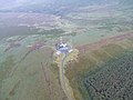 The summit of Mullaghcarn from above
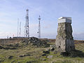 Looking east from summit, towards the cairn, two telecommunications masts and helipad


References
- Placenames Database of Ireland
- Mills, A. D. (2003). A Dictionary of British Place-Names. Oxford University Press. Retrieved 20 January 2009.
- "Omagh". Encyclopædia Britannica. 2009. Retrieved 20 January 2009.
- "Mullaghcarn". MountainViews. Retrieved 20 January 2009.
- The Parliamentary Gazetteer of Ireland. A Fullarton and Co. 1846. pp. 440. Retrieved 20 January 2009.
mullaghcarn.
- "Bessy Bell and Gortin Landscape". Northern Ireland Environment Agency. Archived from the original on 5 August 2012. Retrieved 20 January 2009.
- "Bessy Bell and Gortin Biodiversity Profile". Northern Ireland Environment Agency. Archived from the original on 5 August 2012. Retrieved 20 January 2009.
- "Your Place and Mine - Fecarry Range". BBC.co.uk. British Broadcasting Corporation. Retrieved 20 January 2009.
Mountains and hills of Ulster | ||
|---|---|---|
| Antrim Hills |  | |
| Antrim Plateau |
| |
| Belfast Hills | ||
| Croaghgorms | ||
| Derryveagh | ||
| Inishowen | ||
| Mournes | ||
| Sperrins | ||
| Southwest Donegal | ||
| Others | ||
This article related to the geography of County Tyrone, Northern Ireland is a stub. You can help Wikipedia by expanding it. |
Другой контент может иметь иную лицензию. Перед использованием материалов сайта WikiSort.org внимательно изучите правила лицензирования конкретных элементов наполнения сайта.
WikiSort.org - проект по пересортировке и дополнению контента Википедии