geo.wikisort.org - Mountains
The Brienzer Rothorn is a mountain of the Emmental Alps, in Switzerland. With an elevation of 2,350 metres (7,710 ft) above sea level, the Brienzer Rothorn is the highest summit of the range. To its west lies the Tannhorn, whilst to its east are Arnihaaggen, Höch Gumme and the Brünig Pass (1,008 metres (3,307 ft)). On its south side it overlooks Lake Brienz, whilst to the north it looks out over the Waldemme valley.[3]
| Brienzer Rothorn | |
|---|---|
 View from the west | |
| Highest point | |
| Elevation | 2,350 m (7,710 ft) |
| Prominence | 1,342 m (4,403 ft)[1] |
| Isolation | 9.7 km (6.0 mi)[2] |
| Listing | Canton high point |
| Coordinates | 46°47′13″N 8°02′49″E |
| Naming | |
| English translation | Red Horn of Brienz |
| Language of name | German |
| Geography | |
 Brienzer Rothorn Location in Switzerland | |
| Country | Switzerland |
| Cantons | Lucerne, Obwalden and Bern |
| Parent range | Emmental Alps |
| Topo map | Swiss Federal Office of Topography swisstopo |
| Climbing | |
| Easiest route | mountain train from Brienz, cable car from Sörenberg |
Administratively, the summit is shared by the municipalities of Brienz, to the south-west, Schwanden bei Brienz, to the south-east, Giswil to the north-east, and Flühli, to the north-west. Brienz and Schwanden bei Brienz are in the canton of Bern, Giswil is in the canton of Obwalden, and Flühli is in the canton of Lucerne. The Brienzer Rothorn is the highest point in the canton of Lucerne.[3]
The summit can be reached from Brienz by the Brienz Rothorn Bahn (steam train), the summit station being located at 2,244 metres (7,362 ft) on the Bernese side. It can also be reached from Sörenberg, in Flühli, by cable car.[3]
Gallery
 Steam train (Brienzer Rothorn Bahn) on the Planalp near Mittler Stafel
 Approaching the summit near Ober Stafel
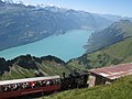 View of Lake Brienz and Interlaken in the background
 The summit station over the clouds ("sea of fog") during a day in August


See also
- List of mountains of Switzerland
- List of mountains of Switzerland accessible by public transport
References
- Retrieved from the Swisstopo topographic maps. The key col is the Brünig Pass (1,008 m).
- Retrieved from Google Earth. The nearest point of higher elevation is north of the Gärstenhoren (Schwarzhorn massif).
- map.geo.admin.ch (Map). Swiss Confederation. Retrieved 2014-10-21.
External links
Authority control | |
|---|---|
| General |
|
| National libraries | |
This article about a mountain, mountain range, or peak located in the canton of Bern is a stub. You can help Wikipedia by expanding it. |
This Canton of Lucerne location article is a stub. You can help Wikipedia by expanding it. |
This article about a mountain, mountain range, or peak located in Obwalden is a stub. You can help Wikipedia by expanding it. |
На других языках
[de] Brienzer Rothorn
Das Brienzer Rothorn (2348 m ü. M.) ist ein Berg in den Emmentaler Alpen, auf der Grenze zwischen den Kantonen Luzern, Obwalden und Bern. Es gehört geologisch zur Wildhorndecke und besteht aus Kalken der Kreidezeit.- [en] Brienzer Rothorn
[fr] Brienzer Rothorn
Le Brienzer Rothorn est une montagne à la limite du canton de Berne, du canton de Lucerne et du canton d'Obwald. On peut atteindre le sommet par un chemin de fer à vapeur, par ailleurs le dernier de Suisse à ne pas être électrifié, et ne fonctionnant qu'en été.[it] Brienzer Rothorn
Il Brienzer Rothorn (2.350 m s.l.m.) è una montagna delle Alpi svizzere, al confine tra i cantoni Lucerna, Obvaldo e Berna.Другой контент может иметь иную лицензию. Перед использованием материалов сайта WikiSort.org внимательно изучите правила лицензирования конкретных элементов наполнения сайта.
WikiSort.org - проект по пересортировке и дополнению контента Википедии