geo.wikisort.org - Mountains
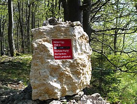
The Hinteri Egg is a mountain of the Jura, located south of Reigoldswil in the Swiss canton of Basel-Landschaft, close to the border with the canton of Solothurn.
| Hinteri Egg | |
|---|---|
 On the summit | |
| Highest point | |
| Elevation | 1,169 m (3,835 ft) |
| Prominence | 165 m (541 ft)[1] |
| Parent peak | Vogelberg (1,204 m) |
| Listing | Canton high point |
| Coordinates | 47°22′21.3″N 7°42′38.4″E |
| Geography | |
| Location | Basel-Landschaft, Switzerland |
| Parent range | Jura Mountains |
The Hinteri Egg reaches a height of 1,169 metres above sea level and is the highest point of the canton of Basel-Landschaft.
References
- Retrieved from the Swisstopo topographic maps. The key col is located south-west of the summit at 1,004 metres.
External links
На других языках
[de] Hinteri Egg
Die Hinteri Egg ist ein Berg im Schweizer Jura mit einer Höhe von 1169 m ü. M.- [en] Hinteri Egg
[fr] Hinteri Egg
Le Hinteri Egg, ou Hinderi Egg, est une montagne du massif du Jura en Suisse. Culminant à 1 168 mètres d'altitude, c'est le point culminant du canton de Bâle-Campagne.Текст в блоке "Читать" взят с сайта "Википедия" и доступен по лицензии Creative Commons Attribution-ShareAlike; в отдельных случаях могут действовать дополнительные условия.
Другой контент может иметь иную лицензию. Перед использованием материалов сайта WikiSort.org внимательно изучите правила лицензирования конкретных элементов наполнения сайта.
Другой контент может иметь иную лицензию. Перед использованием материалов сайта WikiSort.org внимательно изучите правила лицензирования конкретных элементов наполнения сайта.
2019-2025
WikiSort.org - проект по пересортировке и дополнению контента Википедии
WikiSort.org - проект по пересортировке и дополнению контента Википедии
