geo.wikisort.org - Island
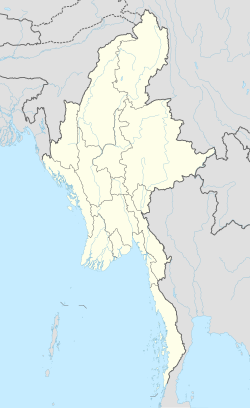
Zalat Taung is an island off the coast of Rakhine State, Burma.
Zalat Taung | |
|---|---|
Island | |
 Zalat Taung | |
| Coordinates: 18°32′10″N 94°14′0″E | |
| Country | Myanmar |
| State | Rakhine |
| Area | |
| • Total | 0.8 km2 (0.3 sq mi) |
| Elevation | 37 m (121 ft) |
| Time zone | UTC+6:30 (Myanmar Standard Time) |
Geography
Zalat Taung is 1.3 km (0.8 mi) long and 0.5 km (0.3 mi) wide. The island is sparsely wooded and rises to a height of 37 m (121 ft) above sea level. It has a small settlement by its north-facing cove. It is separated from the Rakhine coast by a 0.6 km (0.4 mi) wide sound.[1]
Zalat Taung is located at the mouth of the Sandoway (Thandwe) river.[2]
See also
- List of islands of Burma
References
- GoogleEarth
- Prostar Sailing Directions 2005 India & Bay of Bengal. Enroute. National Geospatial-intelligence Agency (Feb 1, 2007). p. 171
External links
Текст в блоке "Читать" взят с сайта "Википедия" и доступен по лицензии Creative Commons Attribution-ShareAlike; в отдельных случаях могут действовать дополнительные условия.
Другой контент может иметь иную лицензию. Перед использованием материалов сайта WikiSort.org внимательно изучите правила лицензирования конкретных элементов наполнения сайта.
Другой контент может иметь иную лицензию. Перед использованием материалов сайта WikiSort.org внимательно изучите правила лицензирования конкретных элементов наполнения сайта.
2019-2025
WikiSort.org - проект по пересортировке и дополнению контента Википедии
WikiSort.org - проект по пересортировке и дополнению контента Википедии