geo.wikisort.org - Island
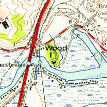
Wood Island is a former island in Marin County, California, formerly in the Corte Madera Creek (upstream of San Francisco Bay) but now surrounded by land. Its coordinates are 37°56′37″N 122°30′42″W[1], and the United States Geological Survey measured its elevation as 13 ft (4.0 m) in 1981.[1] It appears in a 1954 USGS map of the region.[2] In the 1960s, its principal owner was Spero Spiliotis.[3] In 1969, the city of Larkspur passed a resolution of intent to annex the island,[4] and in the 1970s, a ferry terminal had been proposed.[5]
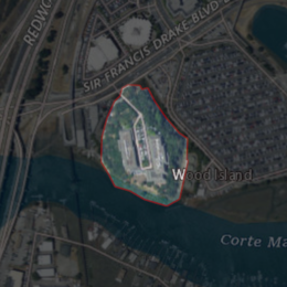 USGS aerial imagery of Wood Island | |
 Wood Island  Wood Island  Wood Island | |
| Geography | |
|---|---|
| Location | Northern California |
| Coordinates | 37°56′37″N 122°30′42″W[1] |
| Adjacent bodies of water | Corte Madera Creek |
| Highest elevation | 13 ft (4 m)[1] |
| Administration | |
United States | |
| State | |
| County | Marin |
References
- U.S. Geological Survey Geographic Names Information System: Wood Island
- United States Geological Survey (1954). "San Rafael Quadrangle, California" (Map). United States Department of the Interior Geological Survey. 1:24000.
- "Wood Island Area Value Is $88,375". Daily Independent Journal. San Rafael, California. 1967-06-23. p. 5.
- "The Larkspur City Council Also". Daily Independent Journal. San Rafael, California. 1969-06-19. p. 18.
- "Larkspur Argues Planning Report". Daily Independent Journal. San Rafael, California. 1972-03-22. p. 37.
Map: Islands of the San Francisco Bay Area | |
|---|---|
 Alameda Bay Farm Brooks Skaggs
(islands of Suisun Bay and the Sacramento–San Joaquin River delta) Newby |
San Francisco Bay watershed | ||
|---|---|---|
| Outline |
|  |
| Subdivisions |
| |
| Waterways |
| |
| Parks and protected areas |
| |
| Islands and peninsulas |
| |
| Wetlands |
| |
| Bridges and tubes |
| |
| Ferries |
| |
| Ports and marinas |
| |
| Other |
| |
| ||
This Marin County, California–related article is a stub. You can help Wikipedia by expanding it. |
Текст в блоке "Читать" взят с сайта "Википедия" и доступен по лицензии Creative Commons Attribution-ShareAlike; в отдельных случаях могут действовать дополнительные условия.
Другой контент может иметь иную лицензию. Перед использованием материалов сайта WikiSort.org внимательно изучите правила лицензирования конкретных элементов наполнения сайта.
Другой контент может иметь иную лицензию. Перед использованием материалов сайта WikiSort.org внимательно изучите правила лицензирования конкретных элементов наполнения сайта.
2019-2026
WikiSort.org - проект по пересортировке и дополнению контента Википедии
WikiSort.org - проект по пересортировке и дополнению контента Википедии