geo.wikisort.org - Island
Rat Rock is an uninhabited, 18-foot (5.5 m) tall rock island in the San Francisco Bay, located just north of China Camp. It serves to protect part of the beach at China Camp from winds which come from the northwest.[2] It appears on a 2015 United States Geological Survey map of the area.[3]
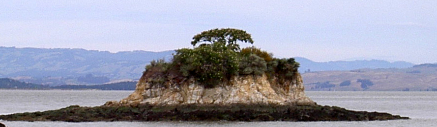 Rat Rock, as seen looking north from China Camp in May 2010. | |
 Rat Rock  Rat Rock  Rat Rock | |
| Geography | |
|---|---|
| Location | Northern California |
| Coordinates | 38°00′16″N 122°27′43″W[1] |
| Highest elevation | 18 ft (5.5 m) |
| Administration | |
United States | |
| State | |
| County | Marin |
References
- U.S. Geological Survey Geographic Names Information System: Rat Rock
- Stienstra, Tom (29 October 2020). "Best 10 places to swim in San Francisco Bay". The San Francisco Chronicle.
- United States Geological Survey (2015). "Petaluma Point Quadrangle, California" (Map). United States Department of the Interior Geological Survey. 1:24000.
Map: Islands of the San Francisco Bay Area | |
|---|---|
 Alameda Bay Farm Brooks Skaggs
(islands of Suisun Bay and the Sacramento–San Joaquin River delta) Newby |
San Francisco Bay watershed | ||
|---|---|---|
| Outline |
|  |
| Subdivisions |
| |
| Waterways |
| |
| Parks and protected areas |
| |
| Islands and peninsulas |
| |
| Wetlands |
| |
| Bridges and tubes |
| |
| Ferries |
| |
| Ports and marinas |
| |
| Other |
| |
| ||
This Marin County, California–related article is a stub. You can help Wikipedia by expanding it. |
Текст в блоке "Читать" взят с сайта "Википедия" и доступен по лицензии Creative Commons Attribution-ShareAlike; в отдельных случаях могут действовать дополнительные условия.
Другой контент может иметь иную лицензию. Перед использованием материалов сайта WikiSort.org внимательно изучите правила лицензирования конкретных элементов наполнения сайта.
Другой контент может иметь иную лицензию. Перед использованием материалов сайта WikiSort.org внимательно изучите правила лицензирования конкретных элементов наполнения сайта.
2019-2026
WikiSort.org - проект по пересортировке и дополнению контента Википедии
WikiSort.org - проект по пересортировке и дополнению контента Википедии