geo.wikisort.org - Island
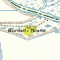
Burdell Island (or Mira Monte)[2] is a former island in the Petaluma River, upstream of San Pablo Bay (an embayment of San Francisco Bay).[3][4] While it was previously surrounded by water and swampland, it is now surrounded mostly by dry land (although it remains much higher than surrounding land). It is part of Marin County, California.[5] Its coordinates are 38°09′22″N 122°33′17″W[1], and the United States Geological Survey gave its elevation as 52 ft (16 m) in 1981.[1] It appears in a 1954 USGS map of the region.[6]
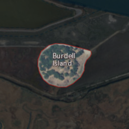 USGS aerial imagery of Burdell Island | |
 Burdell Island  Burdell Island  Burdell Island | |
| Geography | |
|---|---|
| Location | Northern California |
| Coordinates | 38°09′22″N 122°33′17″W[1] |
| Adjacent bodies of water | Petaluma River |
| Highest elevation | 52 ft (15.8 m)[1] |
| Administration | |
United States | |
| State | |
| County | Marin |
References
- U.S. Geological Survey Geographic Names Information System: Burdell Island
- "All aboard for a river tour". Petaluma Argus-Courier. Petaluma, California. 1992-06-05. p. 17.
- "Petaluma River History". Petaluma Argus-Courier. Petaluma, California. 1965-10-21. p. 10.
- "Indians Left Mark Until 1955". Petaluma Argus-Courier. Petaluma, California. 1955-08-17. p. 34.
- "Marinites will decide open space measure". Petaluma Argus-Courier. Petaluma, California. 1992-05-27. p. 13.
- United States Geological Survey (1954). "Petaluma Quadrangle, California" (Map). United States Department of the Interior Geological Survey. 1:62500.
Map: Islands of the San Francisco Bay Area | |
|---|---|
 Alameda Bay Farm Brooks Skaggs
(islands of Suisun Bay and the Sacramento–San Joaquin River delta) Newby |
San Francisco Bay watershed | ||
|---|---|---|
| Outline |
|  |
| Subdivisions |
| |
| Waterways |
| |
| Parks and protected areas |
| |
| Islands and peninsulas |
| |
| Wetlands |
| |
| Bridges and tubes |
| |
| Ferries |
| |
| Ports and marinas |
| |
| Other |
| |
| ||
This Marin County, California–related article is a stub. You can help Wikipedia by expanding it. |
Текст в блоке "Читать" взят с сайта "Википедия" и доступен по лицензии Creative Commons Attribution-ShareAlike; в отдельных случаях могут действовать дополнительные условия.
Другой контент может иметь иную лицензию. Перед использованием материалов сайта WikiSort.org внимательно изучите правила лицензирования конкретных элементов наполнения сайта.
Другой контент может иметь иную лицензию. Перед использованием материалов сайта WikiSort.org внимательно изучите правила лицензирования конкретных элементов наполнения сайта.
2019-2026
WikiSort.org - проект по пересортировке и дополнению контента Википедии
WikiSort.org - проект по пересортировке и дополнению контента Википедии