geo.wikisort.org - Island
Viðoy (Danish: Viderø) is the northernmost island in the Faroe Islands, located east of Borðoy to which it is linked via a causeway. The name means wood island, despite the fact that no trees grow on the island; the name relates to the driftwood that floats in from Siberia and North America.
Viðoy | |
|---|---|
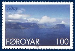
 Stamp FR 349 of Postverk Føroya (issued: 25 May 1999; photo: Per á Hædd) | |
 Location within the Faroe Islands | |
| Coordinates: 62°20′N 6°31′W | |
| State | Kingdom of Denmark |
| Constituent country | Faroe Islands |
| Municipality seat | Viðareiði |
| Area | |
| • Total | 41 km2 (16 sq mi) |
| • Rank | 7 |
| Highest elevation | 841 m (2,759 ft) |
| Population (12-2018) | |
| • Total | 605[1] |
| • Rank | 7 |
| Time zone | UTC+0 (GMT) |
| • Summer (DST) | UTC+1 (EST) |
| Calling code | 298 |
Geography
The island has two settlements: Hvannasund on the south-west coast and Viðareiði on the north-west coast, the northernmost settlement in the Faroes. A road along the west coast of the island connects the two. The island is connected by a road causeway from Hvannasund to Norðdepil on Borðoy, and a bus service from Klaksvík runs across the causeway to the island.[2]
Important bird area
The island's northern and eastern coast has been identified as an Important Bird Area by BirdLife International because of its significance as a breeding site for seabirds, especially European storm petrels (500 pairs), black-legged kittiwakes (5300 pairs), Atlantic puffins (25,000 pairs), common guillemots (6700 individuals) and black guillemots (200 pairs).[3]
Mountains
| Rank | Name | Height (m) |
|---|---|---|
| 3 | Villingadalsfjall | 841 |
| 24 | Nakkurin (norðari) | 754 |
| 29 | Malinsfjall | 750 |
| 52 | Filthatturin | 688 |
| 53 | Oyggjarskoratindur | 687 |
| 67 | Enniberg | 651 |
| 84 | Sneis | 634 |
| 116 | Tunnafjall | 593 |
| 147 | Talvborð | 557 |
| 174 | Mølin | 511 |
| 192 | Nakkurin | 481 |
Viðoy has eleven mountains, of which Villingadalsfjall is the northernmost peak in the Faroes. The north coast also has the Enniberg cliff, which at 750 m is the second-highest sea-cliff in Europe (after Hornelen, in Norway). The mountains are shown with their overall rank in the Faroe Islands.
See also
List of mountains of the Faroe Islands
References
- Statistical Database
- Swaney, Deanna. Iceland, Greenland & the Faroe Islands (3rd ed.). Lonely Planet Publications. ISBN 0-86442-453-1.
- BirdLife International. (2012). Important Bird Areas factsheet: Vidoy.
External links
 Media related to Viðoy at Wikimedia Commons
 The dictionary definition of Viðoy at Wiktionary
- Personal website with 6 aerial photos of Viðoy
На других языках
[de] Viðoy
Viðoy [.mw-parser-output .IPA a{text-decoration:none}ˈviːɔi] (dänisch Viderø) ist eine der 18 Inseln der Färöer und dort die zweitgrößte der sechs Nordinseln.- [en] Viðoy
[es] Viðoy
Viðoy (en danés: Viderø) es la isla más al norte del archipiélago de las Islas Feroe, territorio perteneciente a la corona danesa y situado en el mar de Noruega.[fr] Viðoy
Viðoy (en danois : Viderø) est la plus septentrionale des îles de l'archipel des Féroe située à l'est de Borðoy dont elle n'est séparé au plus près que de quelques dizaines de mètres. Ces deux îles sont reliées depuis 1975 par une route édifiée sur une levée de terre.[it] Viðoy
Viðoy (Viderø in danese) è la più settentrionale delle Isole Fær Øer, situata ad est di Borðoy, alla quale è collegata da un ponte, nel distretto di Norðoyar.[ru] Вийой
Вийой (на старых картах — Видё; фар. Viðoy) — остров, расположенный в северной части Фарерских островов, являющийся самой северной их оконечностью. Располагается между островами Фуглой и Борой.Другой контент может иметь иную лицензию. Перед использованием материалов сайта WikiSort.org внимательно изучите правила лицензирования конкретных элементов наполнения сайта.
WikiSort.org - проект по пересортировке и дополнению контента Википедии