geo.wikisort.org - Mountains
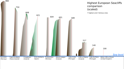
Hornelen is a mountain in Bremanger Municipality in Vestland county, Norway. The mountain sits on the eastern end of the island of Bremangerlandet, along the Frøysjøen strait, in the Nordfjord region of Norway. At 860 metres (2,820 ft), it is the highest sea cliff in Europe (see illustration left), and has for a long time been used as a landmark for naval navigation. It is a 4-hour hike to the summit from Berleneset (across the small fjord from the village of Berle).[3]
| Hornelen | |
|---|---|
 Hornelen, looking southwest from Rugsundøya. | |
| Highest point | |
| Elevation | 860 m (2,820 ft) |
| Prominence | 115 m (377 ft)[1] |
| Coordinates | 61.8557°N 5.2468°E[2] |
| Geography | |
 Hornelen Location of the mountain  Hornelen Hornelen (Norway) | |
| Location | Vestland, Norway |
| Topo map | 1118 I Måløy |
| Climbing | |
| Easiest route | From Berleneset |
The horizontal distance from the summit to the sea is approximately 500 metres (1,600 ft). Approximately 1 kilometre (0.62 mi) to the west of the cliffside is the highest point on the island Bremangerlandet, called Svartevassegga which has an elevation of 889 metres (2,917 ft). The rock in Hornelen consists of sandstone of Devonian age, and it constitutes an important part of the geology of Norway.[4]
See also
- List of mountains of Norway
References
- Bjørstad, Petter. "Hornelen". Retrieved 2010-06-08.
- "Hornelen, Bremanger (Sogn og Fjordane)" (in Norwegian). yr.no. Retrieved 2019-10-13.
- "Bremanger Municipality in Norway". GoNorway.com. Retrieved 3 August 2008.
- Larsen, Bjørn T.; Olaussen, Snorre; Sundvoll, Bjørn; Heereman, Michel (2007). "Volcanoes and faulting in an arid climate". In Ramberg, Ivar; Bryhni, Inge; et al. (eds.). The making of a land: Geology of Norway. Trondheim: Norsk Geologisk Forening. ISBN 978-82-92394-42-7.
This article about a mountain, mountain range, or peak in Vestland is a stub. You can help Wikipedia by expanding it. |
На других языках
[de] Hornelen
Der Hornelen ist ein Berg in der Gemeinde Bremanger in der norwegischen Provinz Vestland. Der Berg liegt am östlichen Ende der Insel Bremangerlandet an der Meerenge Frøysjøen in der norwegischen Region Nordfjord. Mit 860 Metern ist Hornelen die höchste Klippe Europas und wurde lange Zeit als Orientierungspunkt für die Schifffahrt genutzt. Die Wanderung zum Gipfel des Hornelen dauert ca. 4 Stunden von Berleneset aus.[1] Die horizontale Entfernung vom Gipfel zum Meer beträgt ungefähr 500 Meter. Etwa 1 Kilometer westlich der Klippe befindet sich der höchste Punkt der Insel Bremangerlandet, die Svartevassegga mit einer Höhe von 889 Metern. Das Gestein des Hornelen besteht aus Sandstein der Devonzeit und ist ein wichtiger Bestandteil der Geologie Norwegens.[2]- [en] Hornelen
[fr] Hornelen
Le Hornelen est une montagne située sur la côte est de l'île de Bremangerlandet dans le comté de Vestland en Norvège.[it] Hornelen
Hornelen è una montagna situata nel comune di Bremanger, nella contea di Vestlandet, in Norvegia.Другой контент может иметь иную лицензию. Перед использованием материалов сайта WikiSort.org внимательно изучите правила лицензирования конкретных элементов наполнения сайта.
WikiSort.org - проект по пересортировке и дополнению контента Википедии