geo.wikisort.org - Island
Svínoy (Danish: Svinø) is an island located in the north-east of the Faroe Islands, to the east of Borðoy and Viðoy. It takes its name from Old Norse, Svíney, meaning "Swine Isle". Svinoy also refers to a section of the ocean where North Atlantic water flows into the Norwegian Sea.[1] There is a similarly named island, Swona, in the Orkney Islands.
Svínoy | |
|---|---|
 Stamp FR 350 of Postverk Føroya (issued: 25 May 1999; photo: Per á Hædd) | |
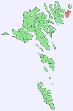 Location within the Faroe Islands | |
| Coordinates: 62°16′N 6°22′W | |
| State | Kingdom of Denmark |
| Constituent country | Faroe Islands |
| Area | |
| • Total | 27.1 km2 (10.5 sq mi) |
| • Rank | 10 |
| Highest elevation | 586 m (1,923 ft) |
| Population (Nov 2020) | |
| • Total | 31 |
| • Density | 1.1/km2 (3.0/sq mi) |
| Time zone | UTC+0 (GMT) |
| • Summer (DST) | UTC+1 (EST) |
| Calling code | 298 |
Svínoy like Kalsoy is a comparatively isolated island, in that there are no bridge, tunnel or causeway links to it. There are boat and helicopter connections.
Geography
Svínoy is divided into two unequally sized peninsulas. The coast is mostly steep slopes and cliffs, including the 345-metre (1,132 ft) precipice of Eysturhøvdi on the north coast. It has only one settlement, also named Svínoy, where all the inhabitants live.
Important Bird Area
The coastline of the island has been identified as an Important Bird Area by BirdLife International because of its significance as a breeding site for seabirds, especially European storm petrels (25,000 pairs), Atlantic puffins (10,000 pairs) and black guillemots (100 pairs).[2]
Mountains

There are seven mountains on Svínoy:
| # | Name | Height |
|---|---|---|
| 1. | Havnartindur | 586 m |
| 2. | Keldufjall | 463 m |
| 2. | Knúkur, vestari | 463 m |
| 4. | Knúkur | 460 m |
| 5. | Múlin | 443 m |
| 6. | Middagur | 422 m |
| 7. | Eysturhøvdi | 344 m |
History
- 975 Viking Chief Svínoyar-Bjarni is mentioned in the Færeyinga saga. A headstone in the church is assumed to be Bjarni's memorial stone.
- 1583 Jacob Eudensen from Svinoy was the last person in the Faroe Islands to be condemned to death for heresy; he had refused to renounce his Catholic faith and convert to Lutheranism.
Gallery
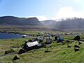 Svínoy village
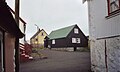 Svínoy
 The coast of Svínoy
 Svínoy in 1899


References
- C.Michael Hogan. 2011. Norwegian Sea. Eds.Peter Saundry & C.J.Cleveland. Encyclopedia of Earth. National Council for science and the Environment. Washington DC
- BirdLife International. (2012). Important Bird Areas factsheet: Svínoy. Downloaded from http://www.birdlife.org on 2012-02-24.
External links
- personal website with 9 aerial photos of Svínoy
Islands of the Faroe Islands | ||
|---|---|---|
На других языках
[de] Svínoy
Svínoy [.mw-parser-output .IPA a{text-decoration:none}ˈsvʊinɔi]/[ˈsvʊinɪ] (wörtlich: Schweineinsel, dänisch: Svinø) ist eine der 18 Inseln der Färöer und gehört zur geografischen Region der sechs Nordinseln. Gleichzeitig hat sie den Status einer „Außeninsel“ (siehe Útoyggjar).- [en] Svínoy
[es] Svínoy
Svínoy (en danés: Svinø) es una de las 18 islas pertenecientes al archipiélago de las Feroe (Dinamarca), situado en el mar de Noruega. La isla tiene 27 km² de superficie y un solo núcleo de población, también llamado Svínoy, con apenas 38 habitantes en 2011.[fr] Svínoy
Svínoy est une île localisée dans le nord-est des îles Féroé, entre Borðoy et Viðoy. L'île ne compte qu'un seul village, Svínoy, où vivent tous les habitants de l'île. Sur le nord-ouest de l'île se situe la falaise de Eysturhøvdi, qui culmine à 345 mètres.[it] Svínoy
Svínoy è un'isola situata nella parte nord-orientale dell'arcipelago delle Isole Fær Øer, a est rispetto all'isola di Borðoy e a ovest di Viðoy. L'isola prende il nome dal norvegese antico Svíney, che significa "isola dei maiali". Il nome è curiosamente simile all'isola Swona, nelle Orcadi.[ru] Свуйной
Свуйной[1] (фар. Svínoy) или Свинё[2] (дат. Svinø) — один из островов Фарерского архипелага, расположенный на его севере. Площадь — 27,24 км²[3]. Население Свуйноя проживает в одноимённом поселении и на октябрь 2021 года насчитывало 31 человек[4].Другой контент может иметь иную лицензию. Перед использованием материалов сайта WikiSort.org внимательно изучите правила лицензирования конкретных элементов наполнения сайта.
WikiSort.org - проект по пересортировке и дополнению контента Википедии