geo.wikisort.org - Island
Hestur (Danish: Hestø) is an island in the central Faroe Islands, to the west of Streymoy and the south of Koltur. Hestur means horse in Faroese.
Hestur | |
|---|---|
 West coast of Hestur | |
 Location within the Faroe Islands | |
| Coordinates: 61°57′10″N 6°53′40″W | |
| State | |
| Constituent country | |
| Area | |
| • Total | 6.1 km2 (2.4 sq mi) |
| • Rank | 15 |
| Highest elevation | 421 m (1,381 ft) |
| Population (2018) | |
| • Total | 20 |
| • Rank | 13 |
| • Density | 3.3/km2 (8.5/sq mi) |
| Time zone | UTC+0 (GMT) |
| • Summer (DST) | UTC+1 (EST) |
| Calling code | 298 |
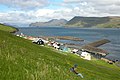
On the west coast is a guillemot colony. In the north there is moorland with four small lakes, of which Fagradalsvatn is the largest. At Hælur, Hestur's southernmost tip, there is a lighthouse. The island has one settlement, a village also named Hestur on the east coast. The village enjoys the view over to Gamlarætt and Velbastaður on Streymoy. There is a ferry link to the port at Gamlarætt.
History
The island has been settled since Viking times; the old settlement was at Hælur, the southern tip of the island. Due to it being the sunward side of the island, cereal ripened better there than anywhere else on the island. But due to extreme difficulties in landing boats there, the village was abandoned and the current village of Hestur was established.
In 1919 a fishing accident resulted in the deaths of one-third of Hestur's men. In an attempt to fight the depopulation of the village, a swimming pool was built on the island in 1974. On the southern part of the island by the lake Fagradalsvatn, one can camp. Hestur's postal code is FO 280. Since 1 January 2005 the island has been part of the municipality of Tórshavn.
Important Bird Area
The coastline of the island has been identified as an Important Bird Area by BirdLife International because of its significance as a breeding site for seabirds, especially Atlantic puffins (25,000 pairs), European storm petrels (5000 pairs) and black guillemots (50 pairs).[1]
Mountains
The island has the following four mountains
| Name | Height |
|---|---|
| Múlin | 421 m |
| Eggjarrók | 421 m |
| Nakkur | 296 m |
| Álvastakkur | 125 m |
Gallery
 Hestur
 Hestur


See also
- List of towns in the Faroe Islands
References
- BirdLife International. (2012). Important Bird Areas factsheet: Hestur. Downloaded from http://www.birdlife.org on 2012-02-23.
External links
- Maps of Hestur Island
- Official site of Faroe Islands
- personal website with 6 aerial photos of Hestur
| Wikimedia Commons has media related to Hestur. |
| Look up Hestur in Wiktionary, the free dictionary. |
Islands of the Faroe Islands | ||
|---|---|---|
На других языках
[de] Hestur
Hestur [.mw-parser-output .IPA a{text-decoration:none}ˈhɛstʊɹ], auch Hestoy [ˈhɛstɔi] (wörtlich: Pferd[e-Insel], dänischer Name: Hestø) ist eine der 18 Inseln der Färöer und gehört zur Region der Hauptinsel Streymoy und der Kommune Tórshavn. Gleichzeitig hat sie den Status einer „Außeninsel“ (siehe Útoyggjar).- [en] Hestur
[es] Hestur
Hestur (también conocida como Hestoy, cuya traducción del feroés sería La Isla de los Caballos) es una de las 18 islas en las que se compone el archipiélago de las Islas Feroe, situado en el Mar de Noruega.[fr] Hestur
Hestur [ˈhɛstʊɹ], aussi nommée Hestoy [ˈhɛstɔi] (littéralement : l'île-cheval), est située dans l'archipel des îles Féroé.[it] Hestur
Hestur è un'isola situata al centro dell'arcipelago delle Isole Fær Øer, in particolare si trova a Ovest di Streymoy e a Sud rispetto a Koltur. Nella lingua Faroese, Hestur significa cavallo. Sulla costa occidentale si trova una grande colonia di urie. La parte settentrionale dell'isola presenta una brughiera con quattro piccoli laghi, il più vasto dei quali si chiama Fagradalsvatn. A Haelur, il capo meridionale di Hestur, si trova un faro.[ru] Хестур
Хестур (фар. Hestur; букв. — «лошадь») или Хестой (фар. Hestoy; букв. — «лошадиный остров») — один из островов Фарерского архипелага.Другой контент может иметь иную лицензию. Перед использованием материалов сайта WikiSort.org внимательно изучите правила лицензирования конкретных элементов наполнения сайта.
WikiSort.org - проект по пересортировке и дополнению контента Википедии