geo.wikisort.org - Island
Vanderlin Island is an island in the Gulf of Carpentaria, Northern Territory, Australia. It is the largest island in the Sir Edward Pellew Group. Its area is 264 km2 (102 sq mi). The island is part of the traditional lands of the Walu people.
The only settlements on the island are four family outstations along the west coast. They are, from north to south:[1][2]
- Mooloowa
- Babungi
- Yulbara
- Uguie
Exact population figures are not known, but family outstations are typically four to six people, which results in a population of approximately 20 for the whole island. In 2019 only one family (Smith) of five persons lives on Vanderlin Island.[3]
Illustrations
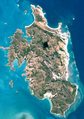 Landsat image of Vanderlin Island
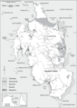 Sketch map of Vanderlin Island


See also
References
- "Roper Gulf Map" (PDF). Australian government.
- BushTel - Remote Communities of the Northern Territory
- "Floortje naar het einde van de wereld". BNNVARA.
Islands of the Northern Territory | |
|---|---|
| |
|
| Australian continent / Australian mainland |
|  |
|---|---|---|
| Queensland |
| |
| Northern Territory |
| |
| Western Australia |
| |
| South Australia |
| |
| Tasmania |
| |
| Related topics |
| |
| ||
This Northern Territory geography article is a stub. You can help Wikipedia by expanding it. |
На других языках
[de] Vanderlin Island
Vanderlin Island ist die größte Insel der Sir-Edward-Pellew-Inseln. Die Inselgruppe liegt im Northern Territory von Australien.- [en] Vanderlin Island
Текст в блоке "Читать" взят с сайта "Википедия" и доступен по лицензии Creative Commons Attribution-ShareAlike; в отдельных случаях могут действовать дополнительные условия.
Другой контент может иметь иную лицензию. Перед использованием материалов сайта WikiSort.org внимательно изучите правила лицензирования конкретных элементов наполнения сайта.
Другой контент может иметь иную лицензию. Перед использованием материалов сайта WikiSort.org внимательно изучите правила лицензирования конкретных элементов наполнения сайта.
2019-2026
WikiSort.org - проект по пересортировке и дополнению контента Википедии
WikiSort.org - проект по пересортировке и дополнению контента Википедии