geo.wikisort.org - Island
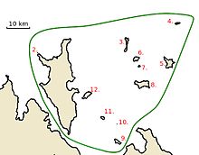
The Croker Group is a group of islands in the Arafura Sea. The group lies offshore from Cobourg Peninsula, and is part of the Northern Territory of Australia. The group is Aboriginal freehold land, held by the Arnhem Land Aboriginal Land Trust.[1]
 Croker Group New Year Island (Northern Territory, Australia) | |
| Geography | |
|---|---|
| Location | Arafura Sea |
| Coordinates | 11.1°S 132.7°E |
| Administration | |
Australia | |
| State | Northern Territory |
| Region | Top End |
The group consists of at least 12 named islands, and a number of small unnamed islands and rocks. By far the largest island of the group is Croker Island, which has an area of 331 km2. Croker Island is also the only permanently inhabited island in the group. None of the other islands in the group is larger than 15 km2.
List of Islands

- Croker Island
- Peacock Island
- Oxley Island
- New Year Island
- McCluer Island
- Lawson Island
- Delphinia Island
- Grant Island
- Valencia Island
- Cowlard Island
- Templer Island
- Darch Island
| Name | Area | Location |
|---|---|---|
| Croker Island | 331 km2 | 11.1333331°S 132.55°E |
| Peacock Island | 0.09 km2[2] | 11.025°S 132.458°E |
| Oxley Island | 2 km2 | 11.00°S 132.826°E |
| New Year Island | 1 km2 | 10.908°S 133.031°E |
| McCluer Island | 9 km2 [3] | 11.07°S 133.0°E |
| Lawson Island | 3 km2 | 11.05°S 132.86°E |
| Delphinia Island | 0.6 km2 | 11.0823°S 132.8775°E |
| Grant Island | 12 km2 | 11.156°S 132.89°E |
| Valencia Island | 3 km2 | 11.383°S 132.785°E |
| Cowlard Island | 0.02 km2 | 11.31669°S 132.78366°E |
| Templer Island | 1 km2 | 11.28927°S 132.727976°E |
| Darch Island | 6 km2 | 11.19519°S 132.662578°E |
See also
References
- "Northern Territory Government: Sites of Conservation Significance" (PDF). Retrieved 23 May 2016.
- "Bonzle: Peacock Island".
- "Bonzle: McCluer Island".
Текст в блоке "Читать" взят с сайта "Википедия" и доступен по лицензии Creative Commons Attribution-ShareAlike; в отдельных случаях могут действовать дополнительные условия.
Другой контент может иметь иную лицензию. Перед использованием материалов сайта WikiSort.org внимательно изучите правила лицензирования конкретных элементов наполнения сайта.
Другой контент может иметь иную лицензию. Перед использованием материалов сайта WikiSort.org внимательно изучите правила лицензирования конкретных элементов наполнения сайта.
2019-2025
WikiSort.org - проект по пересортировке и дополнению контента Википедии
WikiSort.org - проект по пересортировке и дополнению контента Википедии