geo.wikisort.org - Island
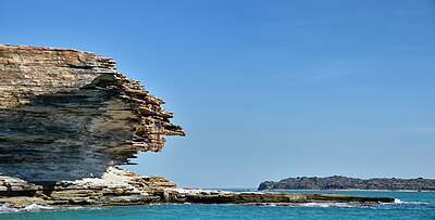
The Sir Edward Pellew Group of Islands is situated in the south-west corner of the Gulf of Carpentaria, off the coast of the Northern Territory, Australia.


History
They were named in 1802 by Matthew Flinders in honour of Sir Edward Pellew, a fellow naval officer. Although Flinders was the first British explorer to pass that way, his journals describe indications of some "foreign" people having visited beforehand. Flinders speculated that these visitors were Chinese. The islands were also sighted in 1644 by Abel Tasman who thought they were part of the mainland and called them "Cape Vanderlin".
Description
The group includes Vanderlin Island, North Island, West Island, Centre Island and South West Island. Combined, the islands have a total area of 2100 square kilometres; the largest, Vanderlin Island, is 32 km long and 13 km wide. Most islands are inhabited (some part-time) by the indigenous Yanyuwa people, and are also part of Wurralibi Aboriginal Land. Tourists may negotiate a fee to visit, camp, and fish there. North Island is home to the 5.41 km² Barranyi (North Island) National Park and offers free camping, with drinking water and barbecue facilities located near Paradise Bay [1] The Pearce, Urquhart and Hervey Islands Important Bird Area, so identified by BirdLife International because of its importance as a breeding site for thousands of terns, comprises three small islands in the group and lies to the north-east of North Island.[2]

References
- "Lengthy land rights claim ends in island ceremony". www.abc.net.au. Retrieved 27 March 2008.[dead link]
- "IBA: Pearce, Urquhart and Hervey Islands (Sir Edward Pellew Group)". Birdata. Birds Australia. Archived from the original on 6 July 2011. Retrieved 16 September 2011.
На других языках
[de] Sir-Edward-Pellew-Inseln
Die Sir-Edward-Pellew-Inseln, eine Gruppe von über 55 Inseln, liegen vor der Nordküste Australiens in der südwestlichen Ecke des Gulf of Carpentaria im großen Mündungssystem des McArthur River im Northern Territory. Der nächstgelegene größere Ort Borroloola ist 60 km landeinwärts auf dem australischen Festland gelegen. Auf den Inseln gibt es acht kleine Orte (Family Outstations) mit jeweils meist vier bis sechs Einwohnern.- [en] Sir Edward Pellew Group of Islands
[fr] Groupe d'îles de Sir Edward Pellew
Le groupe d'îles de Sir Edward Pellew est un groupe d'îles du Territoire du Nord, en Australie, situé dans le coin sud-ouest du golfe de Carpentarie.[it] Isole Sir Edward Pellew
Le Sir Edward Pellew Islands sono un gruppo di isole situate nel golfo di Carpentaria nel Territorio del Nord in Australia. Appartengono alla contea di Roper Gulf.Другой контент может иметь иную лицензию. Перед использованием материалов сайта WikiSort.org внимательно изучите правила лицензирования конкретных элементов наполнения сайта.
WikiSort.org - проект по пересортировке и дополнению контента Википедии