geo.wikisort.org - Island
South Georgia (Spanish: Isla San Pedro) is an island in the South Atlantic Ocean that is part of the British Overseas Territory of South Georgia and the South Sandwich Islands. It lies around 1,400 kilometres (870 mi) east of the Falkland Islands. Stretching in the east–west direction, South Georgia is around 170 kilometres (106 mi) long and has a maximum width of 35 kilometres (22 mi). The terrain is mountainous, with the central ridge rising to 2,935 metres (9,629 ft) at Mount Paget. The northern coast is indented with numerous bays and fjords, serving as good harbours.
 February 2018 ESA satellite photograph of South Georgia | |
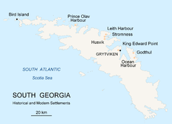 Map of South Georgia Island | |
| Geography | |
|---|---|
| Location | South Atlantic Ocean |
| Coordinates | 54.4°S 36.7°W |
| Archipelago | South Georgia Group |
| Area | 3,528 km2 (1,362 sq mi) |
| Length | 170 km (106 mi) |
| Width | 35 km (21.7 mi) |
| Highest elevation | 2,934 m (9626 ft) |
| Highest point | Mount Paget |
| Administration | |
| Largest settlement | King Edward Point |
| Demographics | |
| Population | 32 (summer) 16 (winter)[citation needed] |
Discovered by Europeans in 1675, South Georgia had no indigenous population due to its harsh climate and remoteness. Captain James Cook in HMS Resolution made the first landing, survey and mapping of the island, and on 17 January 1775 he claimed it a British possession, naming it "Isle of Georgia" after King George III. Through its history, it served as a whaling and seal hunting base, with intermittent population scattered in several whaling bases, the most important historically being Grytviken. The main settlement and the capital today is King Edward Point near Grytviken, a British Antarctic Survey research station, with a population of about 20 people.
History
The island of South Georgia was probably discovered in 1675 by Anthony de la Roché,[1][2] a London merchant, and was named Roche Island on a number of early maps. It was sighted by a commercial Spanish ship named León operating out of Saint-Malo on 28 June or 29 June 1756.[3] According to Argentine historians, it was explored on 29 June 1756, St Peter's Day, hence its Spanish name Isla San Pedro, literally "St Peter's Island".[4]
The mariner Captain James Cook in HMS Resolution made the first landing, survey and mapping of South Georgia. As mandated by the Admiralty, on 17 January 1775 he took possession for Britain and renamed the island 'Isle of Georgia' for King George III.[5]
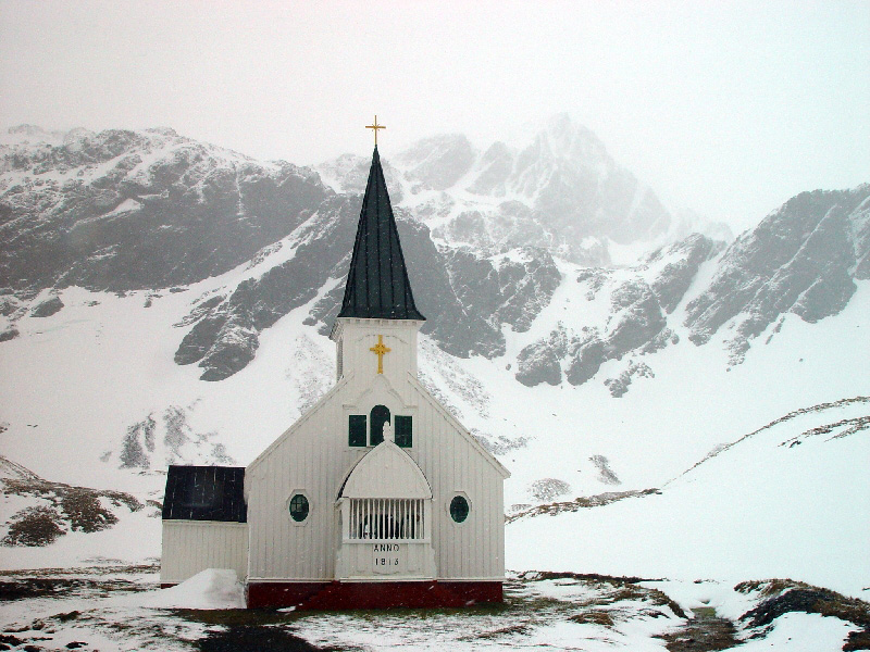
After making a foot crossing of the island with Tom Crean and Frank Worsley,[6] Ernest Shackleton organised the rescue of his party from Elephant Island following the disaster that befell the 1916 Imperial Trans-Antarctic Expedition, which he led.[7] He is buried in the cemetery at Grytviken alongside Frank Wild.[8]
Commercial sealing was conducted on the island between 1786 and 1913. During that period 131 sealing visits are recorded, eight of which ended when the vessel was wrecked.[9] Modern industrial sealing associated with whaling stations was carried out between 1909 and 1964. Sealing era relics include iron try pots, hut ruins, graves and inscriptions, and the South Georgia Museum was established on the island in 1992.[10]
Surveying by Carse
The island was surveyed by explorer Duncan Carse. He organised and led the South Georgia Survey of 1951–57, surveying much of the interior of the island. Mount Carse and Carse Point are named after him. In 1961 he lived as a hermit in a remote part of South Georgia. Carse built a house at Ducloz Head on the southern coast of the island, intending to live there through the winter. However, in May, three months into the experiment, surge waves destroyed his camp. He managed to salvage enough gear to survive the winter until making contact with a ship 116 days later.[11]
His knowledge and mapping proved helpful to the British during the Falklands conflicts.
Argentine occupation
On 19 March 1982, a group of Argentinians arrived at Leith Harbour and raised the Argentine flag on the island. On 3 April, the second day of the Falklands War, Argentine naval forces occupied the island. South Georgia was retaken by British forces on 25 April during Operation Paraquet.[12]
Geography and fauna

The island's climate is classified as an ET or polar tundra climate on the Köppen-Geiger classification system. It has no tree cover, and there is generally snow on the island during the winter months (April–November). The terrain is mountainous, with a central ridge and many fjords and bays along the coast. South Georgia is a breeding ground for elephant seals,[13] fur seals,[14][15] and king penguins. The island is home to the South Georgia pintail and the South Georgia pipit, the only known habitat for these birds.[16]
There are 25 native vascular plants on South Georgia, and 76 non-native species have been recorded.[17][18]
The island's topography includes a stepped sequence of flat surfaces interpreted as wave-cut platforms formed when sea level was higher relative to the island. At sea level strandflats have been described.[19]
In 2013, teams of Norwegian government shooters and Sámi reindeer herders culled all 3,500 reindeer on the island. The animals had been introduced by Norwegian whalers in the early 20th century for food and sport hunting, but were later seen as a pest, damaging the island's flora and wider ecosystem. Karl Erik Kilander, the project manager, said the culled reindeer were frozen and taken to the Falkland Islands where they were sold to local residents and cruise ship operators.[20]
In 2018, after a multiyear extermination effort, the island was declared free of invasive rodents and the number of South Georgia pipits had clearly increased.[21][22][23]
The island lies in the path of large icebergs drifting northward from Antarctica. Iceberg A-38 grounded off the island in 2004, resulting in indirect but severe effects on local wildlife by disturbing life on the seafloor and blocking foraging routes of seals and penguins. In 2020, the colossal 4,200-square-kilometre (1,600 sq mi) Iceberg A-68, similar in size to the island itself, was initially believed to be on a similar collision course but broke apart before collision with the island.[24][25][26]
| Climate data for Grytviken/King Edward Point (Köppen ET) | |||||||||||||
|---|---|---|---|---|---|---|---|---|---|---|---|---|---|
| Month | Jan | Feb | Mar | Apr | May | Jun | Jul | Aug | Sep | Oct | Nov | Dec | Year |
| Record high °C (°F) | 24.5 (76.1) |
26.5 (79.7) |
28.8 (83.8) |
19.1 (66.4) |
17.5 (63.5) |
14.0 (57.2) |
13.6 (56.5) |
13.2 (55.8) |
17.0 (62.6) |
20.0 (68.0) |
22.5 (72.5) |
21.5 (70.7) |
28.8 (83.8) |
| Average high °C (°F) | 8.4 (47.1) |
9.1 (48.4) |
8.4 (47.1) |
5.6 (42.1) |
2.9 (37.2) |
0.9 (33.6) |
1.2 (34.2) |
1.5 (34.7) |
3.5 (38.3) |
5.4 (41.7) |
6.5 (43.7) |
7.5 (45.5) |
5.1 (41.2) |
| Daily mean °C (°F) | 4.6 (40.3) |
5.1 (41.2) |
4.4 (39.9) |
2.3 (36.1) |
0.0 (32.0) |
−1.6 (29.1) |
−1.5 (29.3) |
−1.8 (28.8) |
−0.1 (31.8) |
1.6 (34.9) |
2.7 (36.9) |
3.7 (38.7) |
1.6 (34.9) |
| Average low °C (°F) | 1.4 (34.5) |
1.7 (35.1) |
1.0 (33.8) |
−0.8 (30.6) |
−3.1 (26.4) |
−4.6 (23.7) |
−4.7 (23.5) |
−4.9 (23.2) |
−3.3 (26.1) |
−1.8 (28.8) |
−0.5 (31.1) |
0.4 (32.7) |
−1.6 (29.1) |
| Record low °C (°F) | −4.1 (24.6) |
−3.7 (25.3) |
−6.3 (20.7) |
−9.8 (14.4) |
−11.4 (11.5) |
−14.6 (5.7) |
−15.2 (4.6) |
−19.2 (−2.6) |
−18.4 (−1.1) |
−11 (12) |
−6.4 (20.5) |
−5.4 (22.3) |
−19.2 (−2.6) |
| Average precipitation mm (inches) | 92 (3.6) |
114 (4.5) |
136 (5.4) |
139 (5.5) |
137 (5.4) |
135 (5.3) |
149 (5.9) |
149 (5.9) |
92 (3.6) |
80 (3.1) |
93 (3.7) |
88 (3.5) |
1,394 (54.9) |
| Average precipitation days (≥ 0.1 mm) | 12 | 13 | 14 | 14 | 12 | 15 | 15 | 14 | 11 | 12 | 11 | 11 | 154 |
| Average relative humidity (%) | 72 | 69 | 69 | 70 | 74 | 75 | 74 | 73 | 72 | 70 | 69 | 71 | 72 |
| Mean monthly sunshine hours | 152 | 160 | 127 | 66 | 34 | 12 | 22 | 74 | 123 | 171 | 174 | 167 | 1,282 |
| Source 1: Globalbioclimatics/Salvador Rivas-Martínez[27] | |||||||||||||
| Source 2: DMI/Danish Meteorology Institute (sun, humidity, and precipitation days 1931–1960)[28] | |||||||||||||
| Climate data for Bird Island (Köppen ET) | |||||||||||||
|---|---|---|---|---|---|---|---|---|---|---|---|---|---|
| Month | Jan | Feb | Mar | Apr | May | Jun | Jul | Aug | Sep | Oct | Nov | Dec | Year |
| Record high °C (°F) | 11.2 (52.2) |
10.7 (51.3) |
10.5 (50.9) |
10.2 (50.4) |
6.9 (44.4) |
6.0 (42.8) |
5.9 (42.6) |
4.8 (40.6) |
7.5 (45.5) |
10.4 (50.7) |
9.1 (48.4) |
9.4 (48.9) |
11.2 (52.2) |
| Average high °C (°F) | 5.5 (41.9) |
5.6 (42.1) |
4.4 (39.9) |
1.9 (35.4) |
−0.5 (31.1) |
−1.8 (28.8) |
−2.4 (27.7) |
−1.9 (28.6) |
−0.2 (31.6) |
1.6 (34.9) |
3.4 (38.1) |
4.5 (40.1) |
1.7 (35.0) |
| Daily mean °C (°F) | 3.1 (37.6) |
3.5 (38.3) |
2.5 (36.5) |
0.4 (32.7) |
−2.1 (28.2) |
−3.2 (26.2) |
−3.9 (25.0) |
−3.3 (26.1) |
−1.8 (28.8) |
−0.2 (31.6) |
1.0 (33.8) |
2.0 (35.6) |
−0.2 (31.7) |
| Average low °C (°F) | 0.7 (33.3) |
1.4 (34.5) |
0.6 (33.1) |
−1 (30) |
−3.8 (25.2) |
−4.6 (23.7) |
−5.4 (22.3) |
−4.8 (23.4) |
−3.4 (25.9) |
−1.9 (28.6) |
−1.5 (29.3) |
−0.6 (30.9) |
−2.0 (28.4) |
| Record low °C (°F) | −2 (28) |
−1.7 (28.9) |
−3.2 (26.2) |
−4.6 (23.7) |
−7.3 (18.9) |
−8.5 (16.7) |
−11.4 (11.5) |
−10.6 (12.9) |
−8.5 (16.7) |
−6.6 (20.1) |
−4.3 (24.3) |
−2.8 (27.0) |
−11.4 (11.5) |
| Average precipitation mm (inches) | 84 (3.3) |
80 (3.1) |
95 (3.7) |
123 (4.8) |
108 (4.3) |
108 (4.3) |
120 (4.7) |
114 (4.5) |
107 (4.2) |
98 (3.9) |
88 (3.5) |
77 (3.0) |
1,204 (47.4) |
| Source 1: Climatic Research Unit, UEA[29] | |||||||||||||
| Source 2: Météo Climat[30] | |||||||||||||
See also
- List of landforms of South Georgia
- Ryan Reef
- Storer Reef
- Sutton Crag
- Whalers Passage
References
- Hayward, R.J.C. (1983). "Glacier fluctuations in South Georgia, 1883–1974" (PDF). British Antarctic Survey Bulletin (52): 47. Retrieved 25 December 2020.
- L. Ivanov and N. Ivanova. Roché Island / South Georgia. In: The World of Antarctica. Generis Publishing, 2022. pp. 68-70. ISBN 979-8-88676-403-1
- "Historia General de las Relaciones Exteriores de la República Argentina: Georgias del Sur" [General History of Foreign Relations of the Argentine Republic: South Georgia Islands]. www.argentina-rree.com (in Spanish). Instituto Iberoamérica y el Mundo. Archived from the original on 23 September 2015. Retrieved 18 July 2017.
- Destéfani, Laurio Hedelvio (1982). Malvinas, Georgias y Sandwich del Sur ante el conflicto con Gran Bretaña (in Spanish). Buenos Aires: Edipress. p. 111. ISBN 9500169002.
- Kippis, Andrew. The Life and Voyages of Captain James Cook, p. 254. United Kingdom, G. Newnes, limited, 1904.
- Jonathan Amos (4 February 2022). "Walking in Shackleton's footsteps". Retrieved 4 February 2022.
- Shackleton, E. (1919). South. London: W. Heinemann. p. 208-213. OCLC 715091038.
- "Forgotten hero Frank Wild of Antarctic exploration finally laid to rest, beside his 'boss' Sir Ernest Shackleton". Telegraph. London, UK. 27 November 2011. Archived from the original on 28 November 2011. Retrieved 21 May 2018.
- R.K. Headland, (ed.) Historical Antarctic sealing industry, Scott Polar Research Institute (Cambridge University), 2018, p. 168, ISBN 978-0-901021-26-7.
- Amos, Owen (20 January 2022). "South Georgia: The museum at the end of the world reopens for business". BBC News. Retrieved 21 January 2022.
- Poncet, Sally (2005). A visitor's guide to South Georgia. Kim Crosbie. [Great Britain]: WildGuides. ISBN 1-903657-08-3. OCLC 76990564.
- Freedman, Lawrence (2005). The Official History of the Falklands Campaign: The origins of the Falklands war. Routledge. p. 222. ISBN 0-7146-5206-7.
- Boyd, I. L., Walker, T. R., & Poncet, J. (1996). Status of southern elephant seals at South Georgia. Antarctic Science, 8(3), 237–244. doi:10.1017/S0954102096000338
- Boyd, I. L., McCafferty, D. J., & Walker, T. R. (1997). Variation in foraging effort by lactating Antarctic fur seals: response to simulated increased foraging costs. Behavioral Ecology and Sociobiology, 40(3), 135–144. doi:10.1007/s002650050326
- Boyd, I. L., McCafferty, D. J., Reid, K., Taylor, R., & Walker, T. R. (1998). Dispersal of male and female Antarctic fur seals (Arctocephalus gazella). Canadian Journal of Fisheries and Aquatic Sciences, 55(4), 845–852. doi:10.1139/f97-314
- Amos, Jonathan (9 May 2018). "Rodents driven from South Georgia". BBC News. Retrieved 9 May 2018.
- Galbraith, Deirdre. (2011). A field guide to the flora of South Georgia. Great Britain: South Georgia Heritage Trust. ISBN 978-0-9564546-0-7. OCLC 714041780.
- Upson, Rebecca; Myer, Bradley; Floyd, Kelvin; Lee, Jennifer; Clubbe, Colin (15 March 2018). Field guide to the introduced flora of South Georgia. Richmond, Surrey, UK. ISBN 978-1-84246-652-0. OCLC 1007331209.
- Chalmers, M.; Clapperton, M.A. (1970). Geomorhpology of the Stromness Bay – Cumberland Bay area, South Georgia (PDF) (Report). British Antarctic Survey Scientific Reports. Vol. 70. pp. 1–25. Retrieved 29 January 2018.
- Bazilchuk, Nancy (2013). "Reining in Reindeer on South Georgia Island". Frontiers in Ecology and the Environment. 11 (4): 176. JSTOR 23470940.
- Warren, Matt (8 May 2018). "Rat begone: Record eradication effort rids sub-Antarctic island of invasive rodents". Science. Retrieved 9 May 2018.
- "The Intrepid Rat-Sniffing Terriers of South Georgia Island". atlasobscura.com. 17 May 2018.
- Marris, Emma (11 May 2018). "Birdlife Recovering on Rat-Free Island". National Geographic. Retrieved 6 July 2020.
- Jonathan Amos (4 November 2020). "A68 iceberg on collision path with South Georgia". BBC. Retrieved 4 November 2020.
- European Space Agency (10 November 2020). "Giant berg on collision course with South Georgia". www.esa.int. Retrieved 10 November 2020.
- "Penguins Spared After Mammoth Iceberg Splits Into Smaller Pieces". The Wall Street Journal. 6 February 2021. Retrieved 6 February 2021.
- "Temp/Rain 1901–1950" (PDF). Globalbioclimatics. April 2012. Archived from the original (PDF) on 1 August 2020. Retrieved 10 December 2018.
- Cappelen, John; Jensen, Jens. "South Georgia–Grytviken" (PDF). Climate Data for Selected Stations (1931–1960) (in Danish). Danish Meteorological Institute. p. 242. Archived from the original (PDF) on 27 April 2013. Retrieved 10 December 2018.
- "Climate Normals". Climatic Research Unit, UEA. July 2011. Retrieved 10 July 2011.
- "Weather extremes for Bird Island". Météo Climat. Retrieved 11 November 2019.
Further reading
- Chisholm, Hugh, ed. (1911). . Encyclopædia Britannica. Vol. 25 (11th ed.). Cambridge University Press. p. 513.
- Venables, Stephen (1991). Island at the Edge of the World: a South Georgia odyssey. London: Hodder & Stoughton. ISBN 978-03405-5-600-9.
Capital: King Edward Point | |||||||
| General |
| ||||||
| Settlements / Whaling stations |
| ||||||
| South Georgia islands |
| ||||||
| South Sandwich Islands |
| ||||||
| Seamounts | |||||||
| Landmarks |
| ||||||
Authority control | |
|---|---|
| General | |
| National libraries | |
| Other |
|
На других языках
[de] Südgeorgien
Südgeorgien (englisch: South Georgia, spanisch: Isla San Pedro oder Georgia del Sur) ist sowohl der Name einer einzelnen Insel als auch die Bezeichnung der Inselgruppe, zu der diese gehört. Das Gebiet zählt politisch zum britischen Überseegebiet Südgeorgien und die Südlichen Sandwichinseln und wird, wie die Falklandinseln, von Argentinien beansprucht.- [en] South Georgia
[es] Isla San Pedro (Georgia del Sur)
La isla San Pedro o Georgia del Sur es la principal del archipiélago de las islas Georgias del Sur, del que constituye la mayor parte de su superficie emergida.[fr] Géorgie du Sud
La Géorgie du Sud (anglais : South Georgia Island, espagnol : Isla San Pedro) est une île située dans le sud de l'océan Atlantique, dans le territoire britannique d'outre-mer de la Géorgie du Sud-et-les îles Sandwich du Sud. Plus grande île du groupe de Géorgie du Sud avec 3 755 km2 de superficie, elle représente la majeure partie du territoire de la Géorgie du Sud et des Îles Sandwich du Sud.[it] Georgia del Sud
La Georgia del Sud o Georgia Australe è un arcipelago situato nell'Oceano Atlantico meridionale; politicamente e amministrativamente è un territorio d'oltremare britannico, facente parte della Georgia del Sud e Isole Sandwich Australi. In passato era, insieme alle isole Sandwich Australi, una dipendenza delle isole Falkland.[ru] Южная Георгия
Южная Георгия (англ. South Georgia, исп. Isla Georgias del Sur) — крупный (площадь суши — 3528 км², всего — 4100 км²[2]) субантарктический остров в южной Атлантике, является крупнейшим в одноимённом архипелаге. Административно является частью заморской территории Великобритании Южная Георгия и Южные Сандвичевы Острова (то есть принадлежат Великобритании, но не являются её частью).Другой контент может иметь иную лицензию. Перед использованием материалов сайта WikiSort.org внимательно изучите правила лицензирования конкретных элементов наполнения сайта.
WikiSort.org - проект по пересортировке и дополнению контента Википедии