geo.wikisort.org - Island
Thule Island, also called Morrell Island, is one of the southernmost of the South Sandwich Islands, part of the grouping known as Southern Thule. It is named, on account of its remote location, after the mythical land of Thule, said by ancient geographers to lie at the extreme end of the Earth. The alternative name Morrell Island is after Benjamin Morrell, an American explorer and whaling captain. It was espied by James Cook and his Resolution crew on 31 January 1775 during his attempt to find Terra Australis.[1]
 NASA Terra ASTER image of Thule Island | |
 Location of Thule Island | |
| Geography | |
|---|---|
| Coordinates | 59°27′S 27°18′W |
| Archipelago | South Sandwich Islands |
| Area | 5.5 km2 (2.1 sq mi) |
| Highest elevation | 3,525 ft (1074.4 m) |
| Administration | |
United Kingdom | |
| South Georgia and the South Sandwich Islands | |
| Demographics | |
| Population | Uninhabited |
Geography
Thule Island is approximately triangular in shape and 14 square kilometres (5+1⁄2 sq mi) in area with a long, panhandle-like peninsula called Hewison Point, three kilometres (2 mi), extending to the southeast. Steep slopes ascend to a 1.5-by-2-kilometre (1 by 1+1⁄4 mi) summit caldera with the peak of Mount Larsen at 710 m (2,329 ft) above sea level. Mount Larsen is named after the Antarctic explorer and whaler Carl Anton Larsen. On the southwestern end lies Wasp Point. Off Hewison Point lies the small islet of Twitcher Rock, the southernmost land on Earth except for part of Cook Island, Antarctica and offshore islands considered part of Antarctica.[2]
Thule Island is the westernmost of Southern Thule island group, which also encompasses Cook Island and Bellingshausen Island. It is thought that Thule and Cook may have been a larger single island in the past, and there is evidence for a submerged crater between the two. Steam from the summit crater lake and ash on the flank were reported in 1962. Volcanic heat keeps the crater on Thule Island free from ice. The peak elevation is 1,074 metres (3,525 ft).
Argentine occupation
![Teniente Esquivel Station [es], 1955.](http://upload.wikimedia.org/wikipedia/commons/1/1c/Teniente_Esquivel-ss17.jpg)
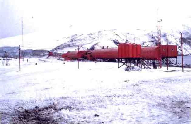
Argentina, in order to assert its claim over the South Sandwich Islands, established the summer station Teniente Esquivel at Ferguson Bay on the southeastern coast on January 25, 1955. The station had to be evacuated in January 1956 because of volcanic eruption of Mount Holdgate (so named in 1964) on the neighboring Cook Island to the east. In 1976 it established a military base on Thule Island called Corbeta Uruguay (Port Faraday) in the lee (southern east coast) of the island. The British discovered the presence of the Argentine base the same year but chose to pursue a diplomatic solution to the issue until the breakout of the Falklands War in 1982. The base was occupied by British forces in the aftermath of the war and eventually destroyed later that year.[3]
See also
- Cape Flannery
- Herd Point
- List of Antarctic and sub-Antarctic islands
- Morrell Point
- Wasp Point
References
Notes
- Schalansky, Judith (2010). Atlas of Remote Islands. New York, NY: Penguin. p. 50. ISBN 978-0-14-311820-6.
- Maxar Technologies (2021). "Southern Thule" (Map). Google Earth. Retrieved 11 July 2021.
- Stonehouse, Bernard (2002), Encyclopedia of Antarctica and the southern oceans, Wiley, p. 264, ISBN 978-0-471-98665-2
Sources
- "Southern Thule". Global Volcanism Program. Smithsonian Institution. Retrieved 25 June 2021.
- LeMasurier, W. E.; Thomson, J. W., eds. (1990). Volcanoes of the Antarctic Plate and Southern Oceans. American Geophysical Union. p. 512 pp. ISBN 0-87590-172-7.
- volcano.und.edu
- Thule Island at OceanDots.com at the Wayback Machine (archived December 23, 2010)
External links
 Media related to Thule Island at Wikimedia Commons
Capital: King Edward Point | |||||||
| General |
| ||||||
| Settlements / Whaling stations |
| ||||||
| South Georgia islands |
| ||||||
| South Sandwich Islands |
| ||||||
| Seamounts | |||||||
| Landmarks |
| ||||||
На других языках
[de] Morrell-Insel
Die Insel Morrell-Insel (englisch Morrell Island) ist die zweitgrößte der drei Inseln im Südatlantik, gelegen im subantarktischen Archipel der Südlichen Sandwichinseln, die die Gruppe der Südlichen Thuleinseln bilden. Sie ist benannt nach Benjamin Morrell. Namensvarianten sind Süd-Thule, englisch Thule Island und spanisch Tule del Sur.- [en] Thule Island
[es] Isla Thule
La isla Thule, Tule o Morrell (en inglés: Thule Island), es una de las más australes del archipiélago de las islas Sandwich del Sur. Se encuentra cerca de la isla Cook y de la isla de Bellingshausen, con quienes forma el grupo denominado islas Tule del Sur.[1][2][fr] Île Thule
L'île Thule (aussi appelée île Morrell) est l'une des îles les plus australes des îles Sandwich du Sud, proche de l'île Cook et de l'île Bellingshausen.[it] Isola di Thule
L'isola di Thule (o isola di Morrell, in onore dell'esploratore Benjamin Morrell) è un'isola dell'Atlantico meridionale, la seconda per dimensioni del gruppo delle tre isole Thule australi, a sua volta parte dell'arcipelago delle Sandwich australi. È nota anche come Thule australe, Thule Island in inglese e Tule del Sur in spagnolo.[ru] Туле (Южные Сандвичевы острова)
Ту́ле (англ. Thule Island) — небольшой необитаемый остров в архипелаге Южные Сандвичевы острова в южной части Атлантического океана, которые входят в состав заморской территории Великобритании Южная Георгия и Южные Сандвичевы Острова.Другой контент может иметь иную лицензию. Перед использованием материалов сайта WikiSort.org внимательно изучите правила лицензирования конкретных элементов наполнения сайта.
WikiSort.org - проект по пересортировке и дополнению контента Википедии