geo.wikisort.org - Island
Rongerik Atoll or Rongdrik Atoll (Marshallese: Ron̄dik, [rʷɔŋʷ(ɯ)rʲik][1]) is a coral atoll of 17 islands in the Pacific Ocean, and is located in the Ralik Chain of the Marshall Islands, approximately 200 kilometers (120 mi) east of Bikini Atoll. Its total land area is only 1.68 square kilometers (0.65 sq mi), but it encloses a lagoon of 144 square kilometers (56 sq mi).
This article needs additional citations for verification. (April 2011) |
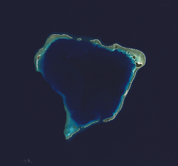 NASA picture of Rongerik Atoll | |
 Rongerik Atoll | |
| Geography | |
|---|---|
| Location | North Pacific |
| Coordinates | 11°20′N 167°27′E |
| Archipelago | Ralik |
| Total islands | 22 |
| Area | 1.68 km2 (0.65 sq mi) |
| Highest elevation | 3 m (10 ft) |
| Administration | |
| Demographics | |
| Population | 0 |
| Ethnic groups | Marshallese (formerly) |
History

Rongerik Atoll was claimed by the German Empire along with the rest of the Marshall Islands in 1884. After World War I, the island came under the South Seas Mandate of the Empire of Japan, although the island was uninhabited. Following the end of World War II, it came under the control of the United States as part of the Trust Territory of the Pacific Islands until the independence of the Marshall Islands in 1986.
It is most famous as the temporary location from March 7, 1946 through March 14, 1948 of the Bikini Atoll's indigenous population while the United States government conducted the Operation Crossroads nuclear tests. After months of food shortages and malnutrition,[citation needed] they were moved first to Kwajalein and finally to Kili Island. On March 1, 1954, Rongerik was exposed to radioactive fallout as a result of the detonation of Operation Castle's Bravo.
According to Spanish researcher Emilio Pastor in a paper submitted to his government in 1948, a number of small islands in Micronesia (Kapingamarangi or Pescadores, Mapia or Güedes, Kiritimati or Matador, Rongerik or Coroa and others) continue legally under Spanish sovereignty. This is because the text of the German–Spanish Treaty of 1899 which transferred sovereignty of certain Spanish possessions in the Pacific to Germany, namely the Northern Mariana Islands (except Guam) and the Caroline Islands (including Palau), failed to include these smaller islands. Although the Spanish government studied the case in 1949 and accepted this interpretation, it has not asserted its claim to the islands.[2]
See also
- Also contaminated by Castle Bravo test: Rongelap Atoll, Utirik Atoll, Ailinginae Atoll
- Desert island
- List of islands
References
External links
- Marshall Islands site
- Entry at Oceandots.com at the Wayback Machine (archived December 23, 2010)
- A Short History of the People of Bikini Atoll
Marshall Islands articles | |||||||
|---|---|---|---|---|---|---|---|
| History |
| ||||||
| Geography |
| ||||||
| Politics |
| ||||||
| Economy |
| ||||||
| Culture |
| ||||||
| |||||||
| Authority control |
|---|
На других языках
[de] Rongdrik
Rongdrik oder Rongerik (deutsch veraltet: Pescadoresinseln[1]) ist ein Atoll der Ralik-Kette der Marshallinseln. Das Atoll hat eine Landfläche von 4,4 km², die eine Lagune von 373 km² umschließt. Das Atoll liegt 200 km vom Bikini-Atoll entfernt.- [en] Rongerik Atoll
[es] Rongrik
Rongerik (También conocido como Rongdrik, Roñdik) es un atolón inhabitado de 1,68 km² en el océano Pacífico. Está formado por 17 islas rodeando una laguna de 144 km². Forma parte de la cadena Ralik en las Islas Marshall, encontrándose a 200 km al este del atolón Bikini. Estados Unidos recolocó en este atolón a los habitantes del atolón Bikini mientras llevaba a cabo las pruebas nucleares. Después de meses de hambruna y desnutrición fueron trasladados a Kwajalein y finalmente a Kili.[fr] Rongerik
L'atoll de Rongerik (nommé aussi Rongdrik ou Roñdik) est un atoll inhabité de 1,68 km2 situé dans l'océan Pacifique. Il fait partie des îles Marshall et se trouve à 200 kilomètres à l'est de l'atoll de Bikini sur la chaîne de Ralik. Avant la Première Guerre mondiale, Rongerik appartenait aux territoires allemands du Pacifique mais n'était pas habitée.[it] Rongrik
L'atollo di Rongerik, conosciuto anche come atollo di Rongdrik o Rondik, è un atollo disabitato di 1,68 km² di superficie situato nell'Oceano Pacifico. È formato da 17 isole che circondano una laguna di 144 km². Fa parte delle Isole Marshall ed è posizionato sulla Ralik Chain, 200 km ad est di Bikini.[ru] Ронгерик
Ронгерик (англ. Rongerik, Rongdrik, марш. Ron̄dik [rʷɔŋʷ(o͡e)r̪ʲi͡ɯk]) — атолл из 14 островков[1] в Тихом океане в составе цепи Ралик (Маршалловы Острова). Площадь сухопутной части составляет примерно 1,68 км², но прилегающая к нему лагуна имеет площадь 144 км². Необитаем.Другой контент может иметь иную лицензию. Перед использованием материалов сайта WikiSort.org внимательно изучите правила лицензирования конкретных элементов наполнения сайта.
WikiSort.org - проект по пересортировке и дополнению контента Википедии