geo.wikisort.org - Island
The Maloelap Atoll (Marshallese: M̧aļoeļap, [mˠɑlˠɔːɛlˠɑpʲ][1]) (also spelled Maleolap) is a coral atoll of 71 islands in the Pacific Ocean, and forms a legislative district of the Ratak Chain of the Marshall Islands. Its land area is only 9.8 square kilometers (3.8 sq mi), but that encloses a lagoon of 972 square kilometers (375 sq mi). It is located 18 kilometers (11 mi) north of the atoll of Aur. In 2011 the population of the islands of the atoll was 682.
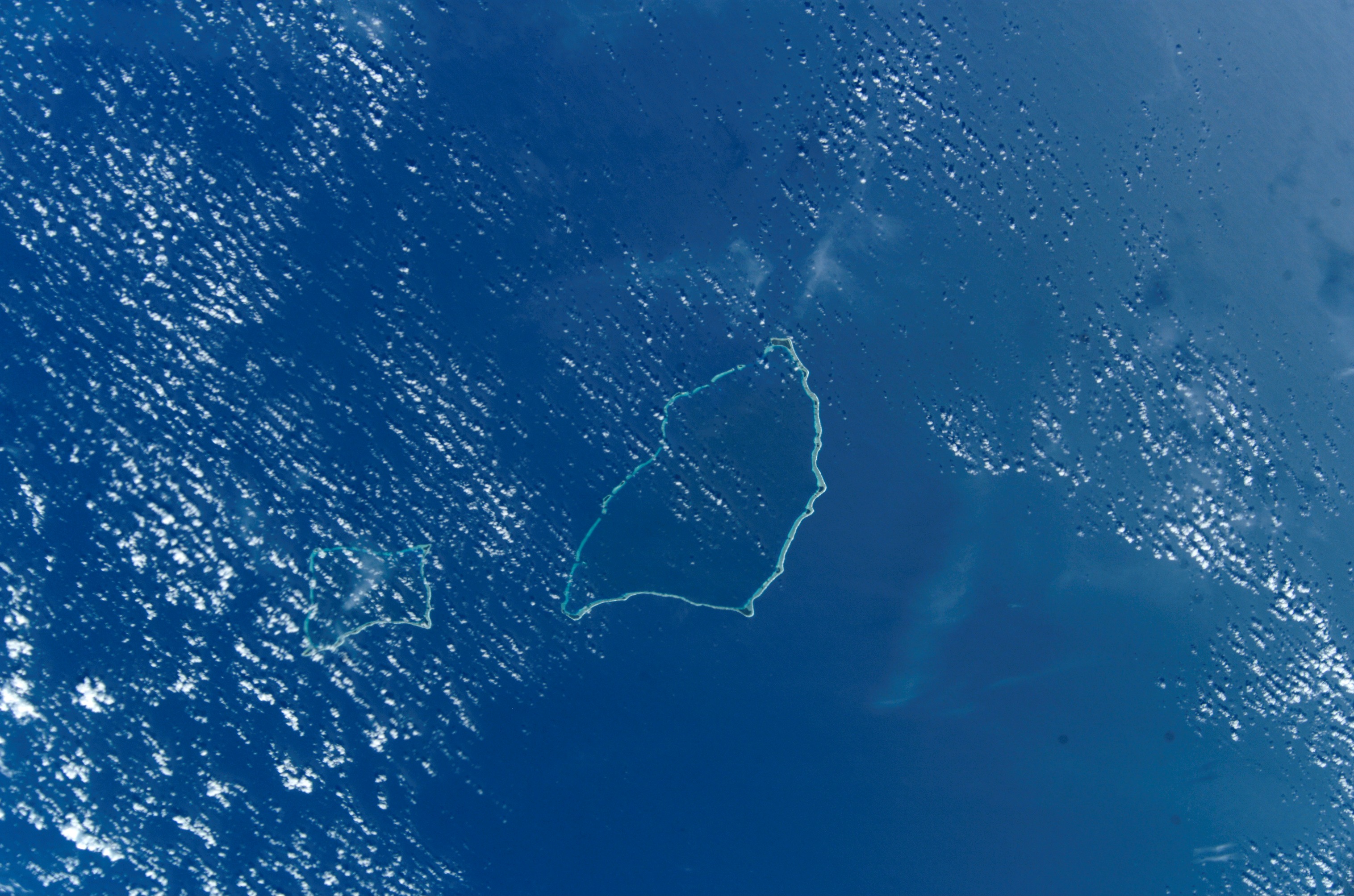 NASA picture of Maloelap Atoll | |
 Maloelap Atoll | |
| Geography | |
|---|---|
| Location | North Pacific |
| Coordinates | 08°45′00″N 171°04′00″E |
| Archipelago | Ratak |
| Total islands | 71 |
| Area | 9.8 km2 (3.8 sq mi) |
| Highest elevation | 3 m (10 ft) |
| Administration | |
| Demographics | |
| Population | 682 (2011) |
| Ethnic groups | Marshallese |
The largest of the islands that make up the atoll are Taroa (the administrative center of the atoll), in the northeast, and Kaben in the northwest. Only three of the other islands in the atoll are inhabited: Airuk, Wolot and Jang. The island is served by Air Marshall Islands via Maloelap Airport.
History
Maloelap Atoll was claimed by the Empire of Germany along with the rest of the Marshall Islands in 1884, and the Germans established a trading outpost. After World War I, the island came under the South Seas Mandate of the Empire of Japan.
In 1939, the Japanese built a seaplane base and landplane Taroa Airfield with two runways (4800' + 4100') and support buildings and facilities, including a radar station. During World War II the Japanese garrison of 2,940 navy men and 389 army men was commanded by Rear Admiral Shoichi Kamada.[2] The perimeter of the island was heavily fortified with 12 heavy coastal artillery and 10 heavy anti-aircraft guns.[2] The island was attacked by the United States Navy beginning in February 1942 starting with carrier-based aircraft and shelling by warships. The attacks grew in frequency and severity after Majuro and Kwajalein had fallen to the Americans. Of the 3097-man Japanese garrison (1772 Imperial Japanese Navy, 368 Imperial Japanese Army, and 957 civilians) only 1041 (34%) survived the war. Several Marshallese were also killed. A large number of war relics, including plane wrecks, mainly Mitsubishi A6M Zero fighters and Mitsubishi G4M Betty bombers remain scattered about.
Following the end of World War II, the island came under the control of the United States as part of the Trust Territory of the Pacific Islands until the independence of the Marshall Islands in 1986. Maloelap Atoll was the first to ratify the Marshall Islands' constitution.
Education
Marshall Islands Public School System operates public schools:[3]
- Aerok Elementary School
- Jang Elementary School
- Kaben Elementary School
- Ollet Elementary School
- Tarawa Elementary School
Northern Islands High School on Wotje serves the community.[4]
Notes
- Marshallese-English Dictionary - Place Name Index
- Takizawa, Akira; Alsleben, Allan (1999–2000). "Japanese garrisons on the by-passed Pacific Islands 1944-1945". Forgotten Campaign: The Dutch East Indies Campaign 1941-1942. Archived from the original on 2016-01-06.
- "Public Schools Archived 2018-02-21 at the Wayback Machine." Marshall Islands Public School System. Retrieved on February 21, 2018.
- "Annual Report 2011-2012." Ministry of Education (Marshall Islands). Retrieved on February 22, 2018. p. 54 (PDF p. 55/118). "Northern Islands High School takes students from the Ratak Ean zone including schools in Aur, Maloelap, Wotje, Ailuk, Utrik, Likiep and Mejit."
References
- Marshall Islands site
- Oceandots entry for Maloelap at the Wayback Machine (archived December 23, 2010)
- Pacific Wrecks
- L, Klemen (1999–2000). "Forgotten Campaign: The Dutch East Indies Campaign 1941-1942". Archived from the original on 2011-07-26.
Marshall Islands articles | |||||||
|---|---|---|---|---|---|---|---|
| History |
| ||||||
| Geography |
| ||||||
| Politics |
| ||||||
| Economy |
| ||||||
| Culture |
| ||||||
| |||||||
На других языках
[de] Maloelap
Maloelap (marshallesisch Ṃaḷoeḷap, weitere Namen: Malolab, Molwonlap, Malangelab, Kaben, Kawen oder Araktschijeffinseln) ist ein Atoll der Ratak-Kette der Marshallinseln. Das Atoll hat eine Landfläche von 9,8 km² bei einer Lagunenfläche von 973 km². Die drei größten Inseln des Atolls heißen Taroa und Knaben im Norden der Insel. Nur drei Inseln des Atolls sind nicht bewohnt, Airok, Ollet und Jang. Das Atoll war das erste, welches die Konstitution der Marshall-Inseln als Staat gebilligt hat. Das 15 km südlich gelegene Atoll Aur liegt am nächsten.- [en] Maloelap Atoll
[es] Maloelap
El atolón Maloelap se compone de 75 islas. Se encuentra en el océano Pacífico y pertenece a las Islas Marshall o Islas de los Pintados en español, como fueron llamadas estas islas por los descubridores españoles. El área asciende a 9,8 km² y la laguna abarca 973 km². La población, en 1999, ascendía a 856.[fr] Maloelap
Maloelap est un atoll de l'océan Pacifique. Il s'agit d'un district des îles Marshall. En 1999, il comptait 856 habitants.[ru] Малоэлап
Малоэлап (Аракчеева) (англ. Maloelap, марш. M̧aļoeļap [mˠɑɫʌ͡ɔɔ̯-ɛ̯ɛ͡ʌɫɑ͡æpʲ]) — атолл в Тихом океане в цепи Ратак (Маршалловы Острова[1]). Состоит из 75 островков. Площадь сухопутной части 9,82 км², вместе с лагуной 973 км². Население 682 человек (2011). Действует аэропорт.Другой контент может иметь иную лицензию. Перед использованием материалов сайта WikiSort.org внимательно изучите правила лицензирования конкретных элементов наполнения сайта.
WikiSort.org - проект по пересортировке и дополнению контента Википедии