geo.wikisort.org - Island
Rathlin Island (Irish: Reachlainn, pronounced [ˈɾˠaxlən̠ʲ]; Local Irish dialect: Reachraidh, Irish pronunciation: [ˈɾˠaxɾˠi]; Scots: Racherie)[2] is an island and civil parish off the coast of County Antrim (of which it is part) in Northern Ireland. It is Northern Ireland's northernmost point.
| Rathlin Island | |
|---|---|
 True-color ESA Sentinel-2 image of Rathlin Island | |
 Rathlin Island Location within Northern Ireland | |
| Population | 154 |
| Irish grid reference | D134518 |
| • Belfast | 47 mi (76 km) |
| District |
|
| County | |
| Country | Northern Ireland |
| Sovereign state | United Kingdom |
| Post town | Ballycastle |
| Postcode district | BT54 |
| Dialling code | 028 |
| Police | Northern Ireland |
| Fire | Northern Ireland |
| Ambulance | Northern Ireland |
| UK Parliament | |
| Website | Rathlin Development & Community Association's official website |
Geography
Rathlin is the only inhabited offshore island of Northern Ireland, with a steadily growing population of approximately 150 people, and is the most northerly inhabited island off the coast of the island of Ireland. The reverse-L-shaped Rathlin Island is four miles (six kilometres) from east to west, and 2+1⁄2 miles (4 kilometres) from north to south.
The highest point on the island is Slieveard, 134 metres (440 feet) above sea level. Rathlin is 15+1⁄2 nautical miles (29 kilometres) from the Mull of Kintyre, the southern tip of Scotland's Kintyre peninsula. It is part of the Causeway Coast and Glens council area, and is represented by the Rathlin Development & Community Association.[3]
Townland
Rathlin is part of the traditional barony of Cary (around the town of Ballycastle), and of current district Moyle. The island constitutes a civil parish and is subdivided into 22 townlands:

| Townland | Area acres[4] |
Population |
|---|---|---|
| Ballycarry | 298 | ... |
| Ballyconagan | 168 | ... |
| Ballygill Middle | 244 | ... |
| Ballygill North | 149 | ... |
| Ballygill South | 145 | ... |
| Ballynagard | 161 | ... |
| Ballynoe | 80 | ... |
| Carravinally (Corravina Beg) | 116 | ... |
| Carravindoon (Corravindoon) | 188 | ... |
| Church Quarter | 51 | ... |
| Cleggan (Clagan) | 202 | ... |
| Craigmacagan (Craigmacogan) | 153 | ... |
| Demesne | 67 | ... |
| Glebe | 24 | ... |
| Kebble | 269 | ... |
| Kilpatrick | 169 | ... |
| Kinkeel | 131 | ... |
| Kinramer North | 167 | ... |
| Kinramer South (Kinramer) | 173 | ... |
| Knockans | 257 | ... |
| Mullindross (Mullindress) | 46 | ... |
| Roonivoolin | 130 | ... |
| Rathlin | 3388 (1371 ha) | ... |
Irish language
The Irish language was originally spoken on Rathlin Island until around the 1960s and was perhaps the main community language until the early 20th century. As it is located between the Irish and Scottish mainland, the dialect found on Rathlin shared many features of both the Irish and Scottish Gaelic languages while also being unique in structure and grammar, e.g. forming plurals with -án or -eán [aːnˠ] doing away with inflection for weak nouns and suffixes for strong ones.[5]
In addition, the phonology of the dialect was quite divergent, compare íorbáll [ˈiːɾˠbˠaːl̪ˠ] with Standard Irish eireaball [ˈɛɾʲəbˠəl̪ˠ] and Scottish Gaelic earball [ˈɛɾɛpəl̪ˠ] ("tail").
Transport
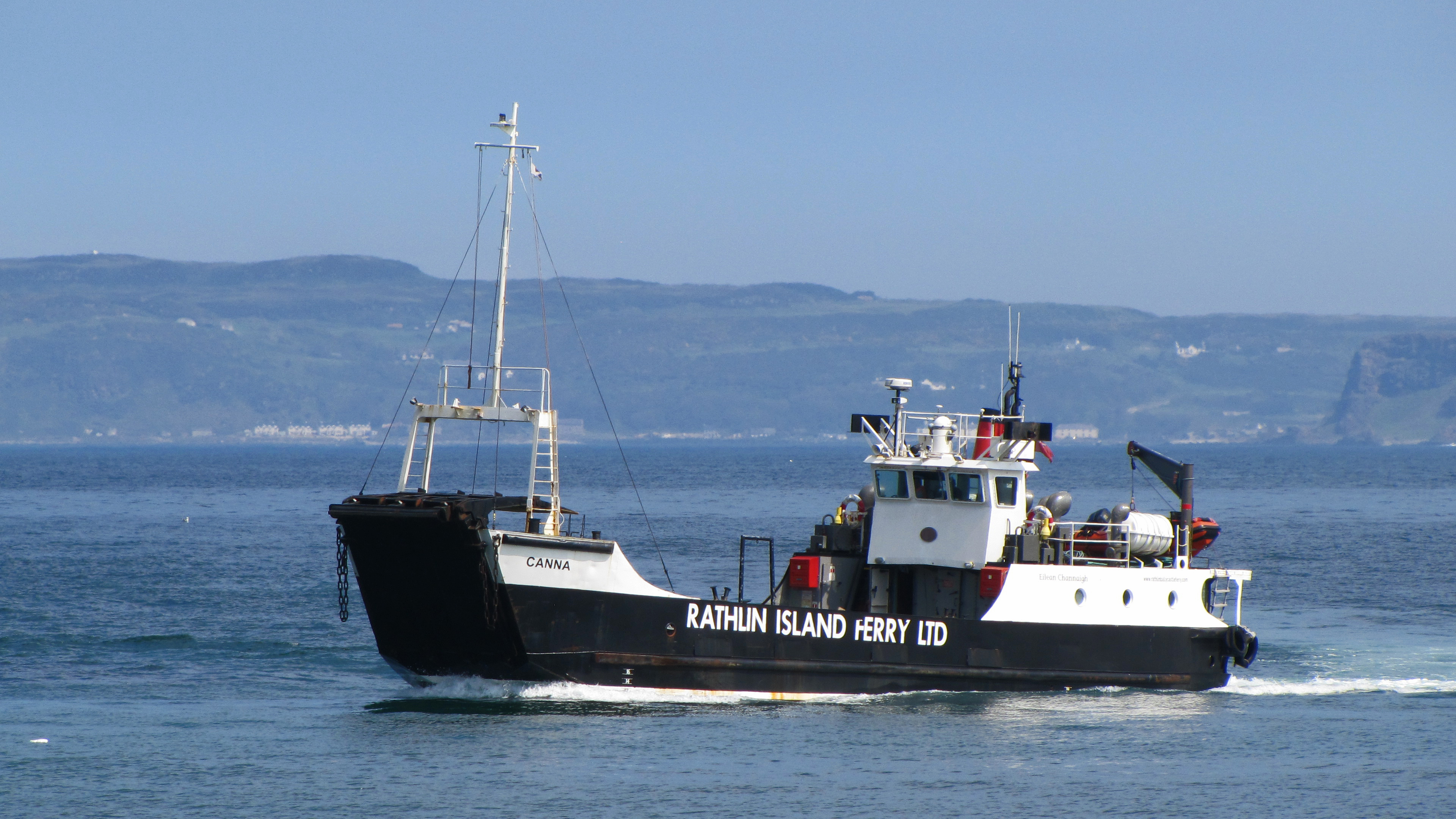

A ferry operated by Rathlin Island Ferry Ltd connects the main port of the island, Church Bay, with the mainland at Ballycastle, six nautical miles (eleven kilometres) away. Two ferries operate on the route – the fast foot-passenger-only catamaran ferry Rathlin Express and a purpose-built larger ferry, commissioned in May 2017, Spirit of Rathlin, which carries both foot passengers and a small number of vehicles, weather permitting.[6][7] Rathlin Island Ferry Ltd won a six-year contract for the service in 2008 providing it as a subsidised "lifeline" service.[8] There is an ongoing investigation on how the transfer was handled between the Environment Minister and the new owners.[9][needs update]
Natural history
Rathlin is of prehistoric volcanic origin, having been created as part of the British Tertiary Volcanic Province.[10]
The island was owned by Rev Robert Gage who was also the island's rector. He had two daughters, Adelaide in 1832[11] and Dorothea in 1835.[12] Adelaide was a botanist who wrote a book concerning the island's flora and fauna.[11] She visited Dorothea in Germany after she married his Serene Highness Albrecht, Prince of Warbeck and Pyrmonte.[12] Adelaide was buried in Ramoan Churchyard in Ballycastle in 1920 and her book on Rathlin is now lost.[11]
Rathlin is one of 43 Special Areas of Conservation in Northern Ireland. It is home to tens of thousands of seabirds, including common guillemots, kittiwakes, puffins and razorbills – about thirty bird families in total. It is visited by birdwatchers, with a Royal Society for the Protection of Birds nature reserve that has views of Rathlin's bird colony. The RSPB has also successfully managed natural habitat to facilitate the return of the red-billed chough. Northern Ireland's only breeding pair of choughs can be seen during the summer months.
The cliffs on this relatively bare island are impressive, standing 70 metres (230 ft) tall. Bruce's Cave[13] is named after Robert the Bruce, also known as Robert I of Scotland: it was here that he was said to have seen the legendary spider which is described as inspiring Bruce to continue his fight for Scottish independence.[14] The island is also the northernmost point of the Antrim Coast and Glens Area of Outstanding Natural Beauty.[15]
In 2008-09, the Maritime and Coastguard Agency of the United Kingdom and the Marine Institute Ireland undertook bathymetric survey work north of Antrim, updating Admiralty charts (Joint Irish Bathymetric Survey Project). In doing so a number of interesting submarine geological features were identified around Rathlin Island, including a submerged crater or lake on a plateau with clear evidence of water courses feeding it. This suggests the events leading to inundation – subsidence of land or rising water levels – were extremely quick.
Marine investigations in the area have also identified new species of sea anemone, rediscovered the fan mussel (the UK's largest and rarest bivalve mollusc – thought to be found only in Plymouth Sound and a few sites off the west of Scotland) and a number of shipwreck sites,[16][17] including HMS Drake,[18] which was torpedoed and sank just off the island in 1917.

Archaeology

The island has been settled at least as far back as the Mesolithic period.[19] A Neolithic stone axe factory featuring porcellanite stone is to be found in Brockley, a cluster of houses within the townland of Ballygill Middle.[20] It is similar to a stone axe factory found at Tievebulliagh mountain on the nearby mainland coast. The products of these two axe factories, which cannot be reliably distinguished from each other, were traded across Ireland; these were the most important Irish stone axe sources of their time.[21]
In 2006, an ancient burial was discovered when a driveway was being expanded by the island's only pub, dating back to the early Bronze Age, ca. 2000 BC. Genomic analysis of DNA from the bodies showed a strong continuity with the genetics of the modern Irish population and established that the continuity of Irish population dates back at least 1000 years longer than had previously been understood.[22][23][24]
There is also an unexcavated Viking vessel in a mound formation.[19]
History
Rathlin was probably known to the Romans, Pliny referring to "Reginia" and Ptolemy to "Rhicina" or "Eggarikenna". In the 7th century, Adomnán mentions "Rechru" and "Rechrea insula", which may also have been early names for Rathlin.[25] The 11th century Irish version of the Historia Brittonum states that the Fir Bolg "took possession of Man and of other islands besides – Arran, Islay and 'Racha'" – another possible early variant.[26]
Rathlin was the site of the first Viking raid on Ireland, according to the Annals of Ulster. The pillaging of the island's church and burning of its buildings took place in 795.
In 1306, Robert the Bruce sought refuge upon Rathlin, owned by the Irish Bissett family. He stayed in Rathlin Castle, originally belonging to their lordship the Glens of Antrim. The Bissetts were dispossessed of Rathlin by the English, who were in control of the Earldom of Ulster, for welcoming Bruce. In the 16th century, the island came into the possession of the MacDonnells of Antrim.
Rathlin has been the site of a number of massacres. On an expedition in 1557, Sir Henry Sidney devastated the island. In July 1575, the Earl of Essex sent Francis Drake and John Norreys to confront Scottish refugees on the island, and in the ensuing massacre, hundreds of men, women and children of Clan MacDonnell were killed.[27][28] Also in 1642, Covenanter Campbell soldiers of the Argyll's Foot were encouraged by their commanding officer Sir Duncan Campbell of Auchinbreck to kill the local Catholic MacDonalds, near relatives of their arch clan enemy in the Scottish Highlands Clan MacDonald. They threw scores of MacDonald women over cliffs to their deaths on rocks below.[29][30] The number of victims of this massacre has been put as low as 100 and as high as 3,000.[citation needed]
On 2 October 1917, the armoured cruiser HMS Drake was torpedoed off the northern Irish coast by German submarine U-79. She steamed into Church Bay on Rathlin Island, where, after her crew was taken off, she capsized and sank.[citation needed] On 27 January 1918, the RMS Andania was hit amidships by a torpedo from German submarine U-46 captained by Leo Hillebrand. The ship immediately took a list to starboard and began to sink. Attempts were made to tow the ship but it sank after a few hours. The passengers were saved, but Andania's sinking killed seven crew members. The wreck is lying at a depth of between 175 and 189 metres.[citation needed]
Commerce

In 1746, the island was purchased by the Reverend John Gage.[31] Rathlin was an important producer of kelp in the 18th century.[32]
A 19th-century British visitor to the island found that they had an unusual form of government where they elected a judge who sat on a "throne of turf".[33] In fact, Robert Gage was the "proprietor of the island" until his death in 1891. Gage held a master's degree from Trinity College, Dublin, but he spent his life on the island creating his book "The Birds of Rathlin Island".[34]
Tourism is now a commercial activity. The island had a population of over one thousand in the 19th century. Its current permanent population is around 125. This is swollen by visitors in the summer, with most coming to view the cliffs and their huge seabird populations. Many visitors come for the day, and the island has around 30 beds for overnight visitors. The Boathouse Visitors' Centre at Church Bay is open seven days a week from April to September, with minibus tours and bicycle hire also available. The island is also popular with scuba divers, who come to explore the many wrecked ships in the surrounding waters.
Richard Branson's hot air balloon crashed near Rathlin Island in 1987.[35]
On 29 January 2008, the RNLI Portrush lifeboat Katie Hannan grounded after a swell hit its stern on breakwater rocks just outside the harbour on Rathlin while trying to refloat an islander's RIB.[36] The lifeboat was declared beyond economical repair[37] and handed over to a salvage company.[38]
Communications
The world's first commercial wireless telegraphy link was established by employees of Guglielmo Marconi between East Lighthouse on Rathlin and Kenmara House in Ballycastle on 6 July 1898.[39]
In July 2013, BT installed a high-speed wireless broadband pilot project to a number of premises, the first deployment of its kind anywhere in the UK, 'wireless to the cabinet' (WTTC) to deliver 80 Mb/s to users.[40]
References
- Chadwick, Hector Munro (1949) Early Scotland: the Picts, the Scots & the Welsh of southern Scotland. Cambridge University Press.
- Watson, W. J. (1994) The Celtic Place-Names of Scotland. Edinburgh; Birlinn. ISBN 1-84158-323-5. First published in Edinburgh; The Royal Celtic Society, 1926.
- Rathlin Island and the Gaelic Language (2005) "Rathlin Island and the Gaelic Language". Rathlin Island and the Gaelic Language
Notes
- Beagmore stone circles and alignments and Cregganconroe court grave NI Department of the Environment. Retrieved 15 October 2012.
- "Place Names NI – Home". placenamesni.org. Retrieved 25 September 2018.
- "The official website of the Rathlin Development & Community Association". Rathlin Community. Retrieved 12 January 2012.
- The Ire Atlas TOWNLAND DATABASE, Civil Parish: Rathlin Island
- "Rathlin Island and the Gaelic Language". Culture Northern Ireland. 24 November 2005.
- "Rathlin". Rathlinweather.co.uk. Retrieved 12 January 2012.
- "Press Release" (PDF). Rathlin Island Ferry Ltd. 28 April 2008. Archived from the original (PDF) on 15 July 2011. Retrieved 2 August 2009.
- "Improved service for Rathlin ferry will half travel time". Northern Ireland Executive. 21 April 2008. Retrieved 2 August 2009.
- "Probe into tendering contract of ferry run". News Letter (Johnston Press). 18 June 2008. Retrieved 2 August 2009.
- "Causeway Coast and Rathlin Island Geodiversity Profile". Northern Ireland Environment Agency. Archived from the original on 7 October 2009. Retrieved 2 August 2009.
- "The Dictionary of Ulster Biography". www.newulsterbiography.co.uk. Retrieved 3 October 2022.
- "The Dictionary of Ulster Biography". www.newulsterbiography.co.uk. Retrieved 3 October 2022.
- "Bruce's Cave". Bruce Rathlin 700. The Ulster-Scots Agency. Archived from the original on 21 October 2011. Retrieved 29 December 2012.
Verifying Rathlin Island's connections with King Robert the Bruce
- "The Spider Legend". Bruce Rathlin 700. The Ulster-Scots Agency. Archived from the original on 8 January 2014. Retrieved 29 December 2012.
It’s a famous story, but is it true?
- "Antrim Coast and Glens AONB". Northern Ireland Environment Agency. Retrieved 2 August 2009.
- "The Joint Irish Bathymetric Survey Project". MCA. Archived from the original (Video) on 26 March 2009. Retrieved 2 August 2009.
- "Prehistoric land under the sea". BBC News. 30 July 2008. Retrieved 2 August 2009.
- Wilson, Ian (2011) HMS Drake. Rathlin Island Shipwreck. Rathlin Island: Rathlin Island Books. ISBN 978-0-9568942-0-5
- O'Sullivan, Aidan & Breen, Colin (2007). Maritime Ireland. An Archaeology of Coastal Communities. Stroud: Tempus. p. 55. ISBN 978-0-7524-2509-2.
- Weir, A (1980). Early Ireland. A Field Guide. Belfast: Blackstaff Press. p. 96.
- Wallace, Patrick F., O'Floinn, Raghnall eds., Treasures of the National Museum of Ireland: Irish Antiquities, pp. 46-47, 2:4, 2002, Gill & Macmillan, Dublin, ISBN 0717128296
- Bronze Age man's burial site unearthed, BBC News, 2 February 2006.
- Ancient DNA sheds light on Irish origins, by Paul Rincon, BBC News 28 December 2015.
- Cassidy LM, Martiniano R, Murphy EM, et al. (2016) Neolithic and Bronze Age migration to Ireland and establishment of the insular Atlantic genome. Proceedings of the National Academy of Sciences 113:368–373.
- Watson (1994) pp. 6, 37.
- Chadwick (1949) p. 83
- John Sugden, "Sir Francis Drake", Touchstone-book, published Simon+Schuster, New York, ISBN 0-671-75863-2
- "Sir Francis Drake and Music". The Standing Stones. Retrieved 2 August 2009.
- Royle, Trevor (2004). Civil War: The Wars of the Three Kingdoms 1638–1660. London: Abacus. ISBN 0-349-11564-8. p.143
- "The Carolingian Era". MacDonnell Of Leinster Association. Archived from the original on 1 October 2011. Retrieved 28 August 2008.
- Ferriter, Diarmaid (4 October 2018). On the Edge: Ireland's off-shore islands: a modern history. Profile Books. ISBN 978-1-78283-252-2.
- O'Sullivan, Aidan & Breen, Colin (2007). Maritime Ireland. An Archaeology of Coastal Communities. Stroud: Tempus. p. 225. ISBN 978-0-7524-2509-2.
- The Saturday Magazine. John William Parker. 1834. p. 134. Retrieved 13 June 2015.
- "The Dictionary of Ulster Biography". newulsterbiography.co.uk.
- Raines, Howell (4 July 1987). "2 Trans-Atlantic Balloonists Saved After Jump into Sea Off Scotland". The New York Times. ISSN 0362-4331. Retrieved 19 February 2019.
- "£2m lifeboat's rescue called off". BBC News. 30 January 2008. Retrieved 8 February 2016.
- Burnham, Nick (18 April 2008). "Lifeboat declared beyond repair". Motor Boat & Yachting. Retrieved 4 November 2022.
- "Permanent replacement lifeboat for Portrush" (Press release). RNLI. 18 April 2008. Retrieved 8 February 2016.[dead link]
- "Guglielmo Marconi 1874–1937". northantrim.com. Retrieved 2 August 2009.
- "BT Ireland". btireland.com. Archived from the original on 2 November 2014. Retrieved 4 July 2013.
External links
Places in County Antrim | ||
|---|---|---|
List of places in County Antrim | ||
| Cities |  | |
| Towns | ||
| Villages |
| |
| Townlands |
| |
| Landforms |
| |
| Baronies | ||
| ||
Geology of Northern Ireland | ||
|---|---|---|
| Volcanism |  | |
| Volcanic plugs |
| |
| Dykes and Sills |
| |
| Metamorphic | ||
| Sedimentary |
| |
| Lists |
| |
Authority control | |
|---|---|
| General |
|
| National libraries | |
| Other |
|
На других языках
[de] Rathlin
Rathlin (engl. Rathlin Island, ir. Reachlainn, früher Raghery Island)[1] ist eine Insel vor der Nordostküste von Nordirland. An dieser Stelle sind es nur 25 Kilometer zur schottischen Halbinsel Kintyre. Die Insel ist L-förmig und misst von West nach Ost sieben, von Nord nach Süd vier Kilometer.- [en] Rathlin Island
[es] Isla de Rathlin
La isla de Rathlin (en inglés: Rathlin Island; en irlandés: Reachlainn o Reachra) es una isla situada en las costas del condado de Antrim en Irlanda del Norte, y es el punto más septentrional de la región. Rathlin es la única isla habitada en Irlanda del Norte, con una población en ascenso de 100 personas, y es la isla habitada más septentrional de las existentes en las costas irlandesas. Con forma de L, Rathlin mide algo más de 6 kilómetros de este a oeste y 4 kilómetros de norte a sur. Se encuentra situada a unos 25 kilómetros del Mull of Kintyre, la punta sur de la península de Kintyre en Escocia. Forma parte del Distrito de Moyle y está representada en el Ayuntamiento por la Rathlin Development & Community Association.[fr] Île de Rathlin
L'île de Rathlin (en irlandais : Reachlainn ou Reachra) est une île au large des côtes de l'île d'Irlande.[it] Rathlin
Rathlin (Reachlainn in gaelico irlandese) è un'isola irlandese che affiora nel Canale del Nord al largo delle coste dell'Antrim, contea dell'Irlanda del Nord. Amministrata dal Distretto di Moyle, dista dalla terraferma meno di 10 km, e dal Mull of Kintyre, punta della Scozia sud-occidentale, soltanto 25 km, mentre morfologicamente è ampia 24 km² ed è caratterizzata da una particolare forma ad elle. Rathlin è l'unica isola rilevante tra quelle che appartengono all'Irlanda del Nord e l'unica abitata fra queste. L'isola rappresenta il punto più settentrionale dell'Irlanda del Nord, se si considerano anche le isole; se si considera invece solo l'isola d'Irlanda, il punto più settentrionale dell'Irlanda del Nord è Benbane Head. Per tutta l'Isola d'Irlanda, Rathlin detiene il record di isola abitata più settentrionale[1].[ru] Ратлин
Ра́тлин (англ. Rathlin, ирл. Reachlainn) — остров в Ирландском море, между побережьем Ирландии (10 км) и оконечностью полуострова Кинтайр (Шотландия) (25 км). Административно относится к Северной Ирландии (графство Антрим, округ Мойл). Единственный населённый пункт — посёлок Чёрч-Бэй, связанный с Балликаслом на ирландском побережье паромным сообщением.Другой контент может иметь иную лицензию. Перед использованием материалов сайта WikiSort.org внимательно изучите правила лицензирования конкретных элементов наполнения сайта.
WikiSort.org - проект по пересортировке и дополнению контента Википедии