geo.wikisort.org - Island
Märket ("The Mark", Swedish pronunciation: [ˈmæ̂rːkɛt]) is a small 3.3-hectare (8.2-acre) uninhabited skerry in the Baltic Sea shared by Sweden and Finland (in the area of the autonomous region Åland), with a lighthouse as its salient humanmade feature.[1] Märket has been divided between the two countries since the Treaty of Fredrikshamn of 1809 defined the border between Sweden and the Russian Empire as going through the middle of the island. The Finnish side of the island is part of the Municipality of Hammarland and is the westernmost land point of Finland.[2] The Swedish part of the island is itself divided by two counties of Sweden: Uppsala County (Östhammar Municipality) and Stockholm County (Norrtälje Municipality).[3]
 Märket Island with the unusual international border of 1985. | |
| Geography | |
|---|---|
| Location | Baltic Sea |
| Coordinates | 60°18′03″N 019°07′53″E |
| Area | 0.03 km2 (0.012 sq mi) |
| Length | 0.35 km (0.217 mi) |
| Width | 0.15 km (0.093 mi) |
| Administration | |
Finland | |
| Region | Åland |
Sweden | |
| Counties | Uppsala län |
| Stockholms län | |
| Demographics | |
| Population | 0 |
| Additional information | |
| Time zone |
|
| Märket lighthouse Märket | |
 | |
| Coordinates | 60.301008°N 19.131432°E |
| Constructed | 1885 |
| Construction | stone and cast iron tower |
| Automated | 1979 |
| Height | 14 metres (46 ft) |
| Shape | cylindrical tower on an octagonal basement rising from a 2-story keeper’s house |
| Markings | white tower and lantern |
| Power source | solar panel, acetylene, diesel generator, kerosene, wind power |
| First lit | 10 November 1885 |
| Focal height | 17 metres (56 ft) |
| Range | 8.5 nmi (15.7 km; 9.8 mi) |
| Characteristic | Fl W 5s. |
Geography and history


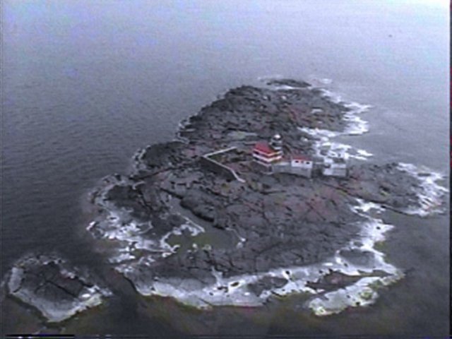
The 6-nautical-mile-wide (11 km; 6.9 mi) Understen–Märket Passage links the Bothnian Sea to the Baltic proper. The skerry is roughly 350 metres (1,150 ft) long by 150 metres (490 ft) wide, and its area is about 3.3 hectares (8.2 acres). It is the smallest sea island shared by two countries.[4] It used to have a straight border until the Grand Duchy of Finland built the lighthouse on the Swedish side and then, they had to change the border. The name Märket ('the Mark') probably comes from its usefulness as a navigation mark before there were lighthouses. The route between Sweden and Åland has a passage about 15 nautical miles (28 km; 17 mi) long over open sea. Before the lighthouse was erected, the island and its shallows were dangerous navigational hazards, which seafarers tried desperately to avoid. In 1873, as many as 23 ships were grounded on the Swedish coast and its archipelago trying to avoid Märket, and eight of them were shipwrecked.[5] Märket is detached from the main Åland archipelago, with the closest island more than 10 km (6.2 mi) away, and the closest harbor, Berghamn, 23 km (14 mi) away in Eckerö. There is no deep harbor; the island can only be reached with boats. There are small, barely surfacing rocks northwest of Märket, called Märketshällor ("stones of Märket"), which are too small to sustain vegetation.
The island consists of mostly smooth diabase rock, with a maximum natural elevation of 2 m (6.6 ft). Most of the area is regularly washed over with seawater in storms, and scoured by drift ice in winter. Plant life, which is limited to low-growing grasses and herbs, persists only in some protected spots. Twenty-three plant species have been identified altogether. The halophilic grass Puccinellia capillaris and the herbaceous Sagina nodosa (knotted pearlwort) are found scattered throughout the island. Among rarer species, Spergularia marina (salt sandspurry) grows on Märket. Salix caprea (goat willow) grows on an abandoned building.[6]
There are large grey seal communities around Märket, and the island has been a target for seal safaris.[7]
International border and lighthouse
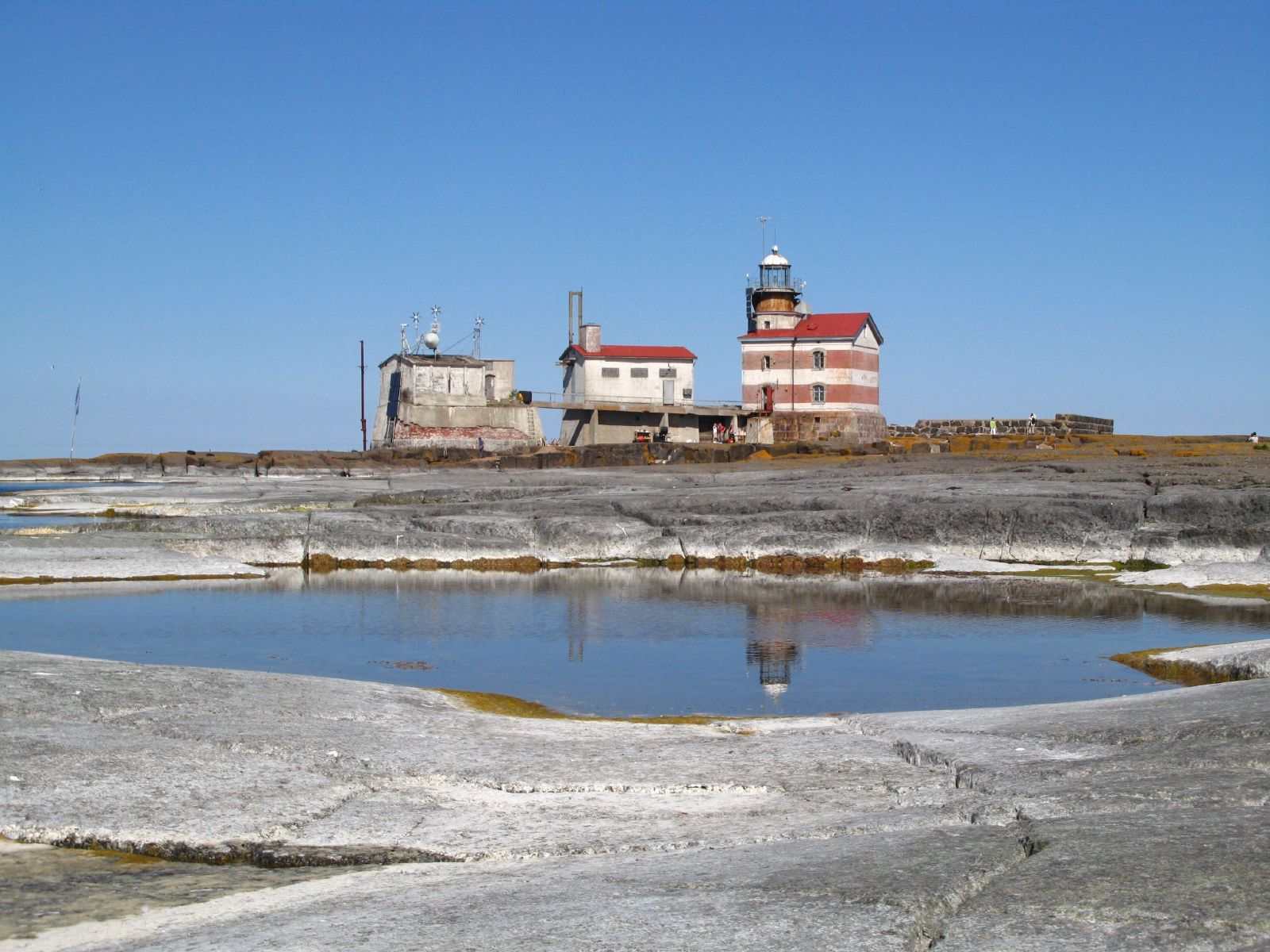
There is a lighthouse on the Finnish side of the current border, which has been unmanned and automated since 1979. When it was built by the Grand Duchy of Finland (then part of the Russian Empire) in 1885, the island was considered a no-man's land, so the lighthouse was simply built upon the highest point of the island.[5] However, the location selected was within the Swedish portion of the island. Though the lighthouse was formally on the Swedish side of the border, it was never considered Swedish, or administrated from Sweden.
As a result, the border was adjusted in 1985 so that the lighthouse is now located on Finnish territory.[8] The adjustment was carried out such that no net transfer of territory occurred, and the ownership of the coastline was unchanged so as not to interfere with each country's fishing rights.
This resulted in an unusual shape for the international border to satisfy both Finnish and Swedish interests. The adjusted border takes the form of an inverted 'S', and the lighthouse is connected to the rest of Finland only by a short stretch of land. The border is regularly resurveyed every 25 years by officials representing both countries. The last such joint inspection took place in August 2006.[9] The border is marked by holes drilled into the rock, because the seasonal drift ice would shear off any protruding markers. Because of the Nordic Passport Union and the Schengen Agreement, there have been no passport checks or other border formalities at the border since 1958, so intra-Nordic/intra-Schengen visitors may visit the island freely.
The lighthouse is in urgent need of maintenance, and a Finnish interest group is trying to raise funds for its preservation.[citation needed] The lighthouse has been automated since 1979 and the surrounding buildings are no longer used. The increasing general availability of GPS has made the lighthouse's primary function redundant.
Radio amateurs activity
Radio amateurs around the world consider the Finnish part of Märket Reef (as they call it) a separate entity, distinct from Finland and Sweden. The Finnish part of Märket Reef used to be one of the world's most desired "countries" to contact among radio amateurs because of its special status and relative remoteness. One or more amateur radio expeditions to the island occur most years, weather permitting. During these expeditions, tens of thousands of radio contacts are made with people in several parts of the world. At high seas, landing is only possible with a helicopter. Pictures of Märket are shown on QSL cards. The official prefix for use on the Finnish side is OJ0 call sign prefix for Märket Reef. An OJ0 vanity callsign can be obtained, for a fee, from Traficom.fi, the Finnish Transport and Communication Agency. Amateurs with licenses in countries supporting CEPT can operate from the reef while using the OJ0/ prefix in front of one's own call sign. All radio activity on the island is by visitors on DX-peditions. When the Finnish part of the reef was given its special status in amateur radio, in the late 1960s the lighthouse keeper himself became a licensed amateur radio operator, who initially used the call OH0MA. On the Swedish side of Märket Reef, the call signs 8S9M and SI8MI have been used.[10]
Climate
Märket has a continental climate affected by oceanic influences; it has a reputation for being one of the windiest places in Finland.[11] A meteorological station has been managed by the lighthouse keepers since 1896, and an automatic station of the Finnish Meteorological Institute was inaugurated on November 10, 1977, shortly before its automation.[12]
The effect of the sea is very important to the climate of the island; thermal inertia dramatically reduces the temperature fluctuations during the year compared to those of the continent, and to a lesser extent, those of the central part of Fasta Åland, the largest island of the archipelago of Åland. Märket holds five records for daytime temperatures among Finnish weather stations, all in the period between November 29 and January 1, with 10.2 °C (50.4 °F) on December 15, 2006, and 8.8 °C (47.8 °F) on December 31, 1975.[13] The average yearly temperature is roughly 6 °C (43 °F) and is one of the highest in Finland, with the month of January being milder than on the continent (−2.5 °C or 27.5 °F on average), and a warm summer (15.9 °C or 60.6 °F on average in July).[14] The island is drier than the mainland; the average annual rainfall does not usually surpass 550 millimetres (22 in).[15]
See also
- List of divided islands
- Bogskär and Lågskär, other detached Finnish islands
- Utö, Finland
- Nuorgam
- Fort Blunder, an American fort mistakenly built in Canada
References
- Rowlett, Russ. "Lighthouses of the Åland Islands". The Lighthouse Directory. University of North Carolina at Chapel Hill. Retrieved January 19, 2016.
- citizen's Map Site – National Land Survey of Finland
- Frank Jacobs (April 24, 2012). "One Island, Two Countries". The New York Times.
- World island superlatives
- Tom Backmansson, 1998. TV series "Fyren - Majakka", episode 10: Märket. First shown on Yle TV1, 16.7.2000 17.59. Produced by Yleisradio Oy, http://areena.yle.fi/1-682613 https://www.youtube.com/watch?v=ytNqj9QfG70
- J. Ekman, L. G. Bråvander, G. Ekman, E. Zachrisson (1998). "Märket - en märklig ö" (PDF). Daphne (in Swedish): 56–58. Archived from the original (PDF) on 2017-10-27. Retrieved 2006-07-14.
{{cite journal}}: CS1 maint: multiple names: authors list (link) - "Hyljesafari" (in Finnish). Retrieved 5 March 2019.
- Märket – a remarkable island Archived 2017-10-27 at the Wayback Machine by Joakim Ekman, Lars-Gunnar Bråvander, Gabriel Ekmand, and Ebbe Zachrisson (in Swedish) includes a map of the island
- Shifting Territories: Märket Reef, Hidden Europe Magazine, 11 (November 2006), pp. 26–29.
- "Islands on the Air - IOTA Directory - Group Information". Archived from the original on 2012-03-09. Retrieved 2011-01-12.
- (in Finnish) Association finlandaise des phares Archived 2007-09-27 at the Wayback Machine – Presentation of the Island
- (in Finnish) Institut météorologique national de Finlande – A list and characteristics of the meteorological stations of Finland
- (in Finnish) Institut météorologique national de Finlande – Statistiques nationales pour le mois de décembre
- (in English) Conseil de coopération nordique Archived 2007-10-14 at the Wayback Machine – Statistiques générales sur Åland
- (in English) Institut météorologique national de Finlande Archived 2010-04-27 at the Wayback Machine – Statistiques climatiques de la période 1971–2000
Gallery
 The island lighthouse

External links
- 2021 OJ0D Satellite Radio DXpedition to Märket
- https://sral.info/2018/06/19/market-calling/
- 2007 Radio DXpedition to Märket
- Configurable map centred on Märket from Citizen's Mapsite of Finland
- The Swedish Lighthouse Society's site on Märket
- Market Reef at MostTraveledPeople.com[permanent dead link]
- Joint border survey between Finland and Sweden in progress from Helsingin Sanomat (International Edition), includes paragraph about Märket, with a small map.
- A recent air photo of the island
- The New York Times on the island
- The Finnish Lighthouse Society
Lighthouses of Finland | |
|---|---|
Italics indicate inactive sites. | |
| Gulf of Finland |
|
| Baltic Sea |
|
| Archipelago Sea and the Sea of Åland | |
| Bothnian Sea | |
| Bothnian Bay |
|
| Former Finnish lighthouses in Russia |
|
Authority control | |||
|---|---|---|---|
| General | |||
| National libraries | |||
| Additional |
| ||
На других языках
[de] Märket
Märket (schwedisch) ist ein flacher Felsen, der sich auf einer Fläche von etwa drei Hektar zwischen dem schwedischen Festland und den finnischen Åland-Inseln aus der Ostsee erhebt.- [en] Märket
[es] Märket
Märket es una pequeña isla en el mar Báltico, compartida entre Finlandia (Estado libre asociado de Åland) y Suecia (provincia de Estocolmo y de Upsala). Rocosa, desnuda y con solo un faro que funciona automáticamente, forma parte de una zona Ramsar, el archipiélago de Signilskär-Märket, gracias a las numerosas aves marinas y focas que viven en ella.[fr] Märket
Märket, en suédois [ˈmærkə(t)], littéralement « la marque »[1], est une petite île de la mer Baltique partagée entre la Finlande (État libre associé d'Åland) et la Suède (comtés de Stockholm et d'Uppsala). Rocheuse, dénudée et n'abritant qu'un phare automatisé, elle est incluse dans un vaste site Ramsar, l'archipel de Signilskär-Märket, grâce aux très nombreux oiseaux marins et phoques qui y vivent.[it] Märket
Märket (pronuncia: ˈmærkə(t), in finlandese Merkki, "Il segno") è una piccola isola scoglio disabitata di 3,3 ettari (8.2 acri) nel Mar Baltico, divisa tra Finlandia e Svezia che fa parte dell'arcipelago delle isole Åland.[ru] Меркет (остров)
Меркет (швед. Märket [mɛrkːet]) — необитаемый остров в проливе Сёдра-Кваркен Балтийского моря. Западная часть острова принадлежит Швеции, восточная часть — Аландским островам (зависимой территории Финляндии). Шведская часть острова разделена между двумя ленами — леном Стокгольм коммуна Норталье и леном Уппсала - коммуна Остхаммер; финляндская часть острова относится к автономной провинции Ахвенанмаа -коммуна Хаммарлад.Другой контент может иметь иную лицензию. Перед использованием материалов сайта WikiSort.org внимательно изучите правила лицензирования конкретных элементов наполнения сайта.
WikiSort.org - проект по пересортировке и дополнению контента Википедии