geo.wikisort.org - Island
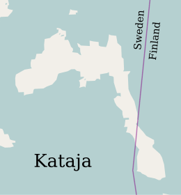
Kataja is an islet south of Haparanda in Norrbotten. It is the easternmost point of Sweden and it is part of the Haparanda archipelago. The islet has an area of 71 hectares (180 acres). It is about 2 kilometres (1.2 mi) long and 200 to 500 metres (660 to 1,640 ft) wide.
Inakari | |
|---|---|
 | |
| Geography | |
| Location | Baltic Sea |
| Coordinates | 65.70105°N 24.16630°E |
| Area | 0.71 km2 (0.27 sq mi) |
| Length | 2 km (1.2 mi) |
| Width | 0.35 km (0.217 mi) |
| Administration | |
Finland | |
| Region | Lapland |
Sweden | |
| County | Norrbotten County |
| Demographics | |
| Population | 0 |
The name "Kataja" is Finnish for juniper. The island is divided between Sweden and Finland. The border was established in 1809 between two islands, a larger Swedish one called Kataja and a smaller Finnish one called Inakari. In the years since then post-glacial rebound has caused the land in the region to rise relative to sea level, joining the two islands. The border now crosses the southeastern part of the combined island, and is marked by two national cairns. Kataja's beaches are mostly boulders with some sand. The eastern peninsula is covered in deciduous trees such as rowan, alder and willow, while the remainder is covered by coniferous trees.[1]
See also
References
Citations
Sources
- "Kataja". bottenviken.se. Retrieved 2020-05-01.
На других языках
[de] Kataja
Kataja ist eine kleine unbewohnte Insel (0,71 km²) im Bottnischen Meerbusen, ungefähr 15 km von der Mündung des Torneälv bei Haparanda und Tornio entfernt. Bemerkenswert ist die Insel deswegen, weil sie zwischen Schweden und Finnland geteilt ist. Zwei Grenzsteine und eine Markscheide markieren die Grenze, die hier gleichzeitig den östlichsten Punkt Schwedens darstellt. Der größte Teil der Insel gehört zu Schweden.- [en] Kataja
[es] Kataja
Kataja es una isla cuyo territorio está dividido entre Suecia y Finlandia. Se encuentra al sur de Haparanda, en el golfo de Botnia, al norte del mar Báltico, y, políticamente, pertenece al condado de Norrbotten. Su área es de aproximadamente 0,71 km², midiendo aproximadamente dos kilómetros de largo por entre 200-500 metros de ancho.[fr] Kataja (île)
Kataja, en finnois Inakari, est une petite île inhabitée du nord du golfe de Botnie séparée par la frontière entre la Finlande et la Suède. Cette frontière, à l'origine maritime, est devenue terrestre sous l'effet du rebond isostatique qui affecte l'ensemble de la Scandinavie, faisant de Kataja l'une des plus petites îles au monde traversées par une frontière internationale.[it] Kataja
Kataja (Inakari in finlandese) è un'isola situata nella parte settentrionale del Golfo di Botnia, al largo della foce del fiume Torne, attraversata dal confine tra Finlandia e Svezia.[ru] Катая
Катая (швед. Kataja, фин. Inakari) — остров на севере Ботнического залива Балтийского моря к югу от Хапаранды, разделённый между Швецией (лен Норрботтен) и Финляндией (провинция Лапландия). Самая восточная точка Швеции.Другой контент может иметь иную лицензию. Перед использованием материалов сайта WikiSort.org внимательно изучите правила лицензирования конкретных элементов наполнения сайта.
WikiSort.org - проект по пересортировке и дополнению контента Википедии