geo.wikisort.org - Island
Mota (formerly Sugarloaf Island) is an island in the Banks group of northern Vanuatu, with a population of about 700.[2]
 Mota in the Banks Islands | |
 | |
| Geography | |
|---|---|
| Coordinates | 13°51′S 167°42′E |
| Archipelago | Banks Islands |
| Area | 9.5 km2 (3.7 sq mi)[1] |
| Highest elevation | 411 m (1348 ft)[1] |
| Administration | |
| Province | Torba |
| Demographics | |
| Population | 683[2] (2009) |
| Pop. density | 71.89/km2 (186.19/sq mi) |
Name
The name Mota is an adaptation of the local name M̄ota [ŋ͡mʷota]. Cognates in other Torres-Banks languages include Mwotlap Am̄ot [aŋ͡mʷɔt],[3] Vera'a M̄ō'o [ŋ͡mʷʊʔɔ], and Vurës M̄ot [ŋ͡mʷɔt]. They are all derived from a form *mʷota in Proto-Torres-Banks, referring to the island. The form is possibly cognate with Proto-Polynesian *motu "island", from Proto-Oceanic *motus "broken off, detached".
The same root is found in Mota Lava, the name of an island north of Mota ‒ etymologically, "big Mota".
Geography
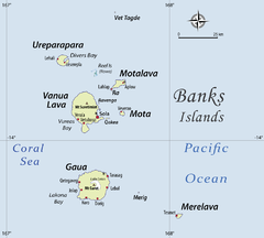
Mota is located 18 km south of Mota Lava and 12 km east of Vanua Lava, the second-largest island in the Banks archipelago. The slightly oval island has a length of 5 km and has an area of 9.5 km².[4]
Mota is formed by an extinct, basaltic volcano, which reaches an altitude of 411 m above sea level in Mount Tawe. The island is surrounded by a fringing reef, and its steep coast makes it difficult to land on from boats.
The climate on the island is humid tropical. The average annual rainfall exceeds 3500 mm. Mota is prone to frequent earthquakes and cyclones.
History
Mota was discovered by the Portuguese navigator Pedro Fernández de Quirós who served for the Spanish expedition on 25 April 1606 and named it Nuestra Señora de la Luz (Our Lady of Light).[5]
The island is famous because its language was used by the first missionaries in Melanesia. For the better part of a century from 1849, most teaching in classrooms and schools of all kinds, and most prayers and hymns from Isabel in the Solomons all the way through Pentecost in Vanuatu were done in the language of this small island. Some Mota words are still known throughout the Melanesian archipelago, e.g. tasiu (brother, taken here in the religious sense of "member of a brotherhood" i.e. the Melanesian Brotherhood)
The famous missionary John Coleridge Patteson lived on Mota, in the village of Veverao. The first Melanesian priest, Father George Sarawia, was from Mota, and the first Christian baptisms and Eucharist and Confirmations were there. Mota is generally held to be the first Melanesian island to have become Christian, though missionary work began a year later than on Aneityum.
Population
683 people live on Mota[2] in coastal villages around the island. The names of the villages are Liwotqei, Lotawan, Mariu, Tasmate, Garamal, Tuqetap, and Veverao. The population speaks the Mota language.
All Mota people are Christians, Anglicans of the Church of the Province of Melanesia. The big days of celebration are the saints' days of the church in each village on the island. However, kastom, i.e. the Melanesian traditions, still means a lot to the islanders.
Presently, the island is ruled by a council of chiefs elected from each village. There is a school, Pasaleli Primary School, formally named Panel School. There is a dispensary where a nurse lives, access to teleradio and a public phone on the island. There are also small settlements of Mota people in Santo, especially at Lorevilko and Turtle Bay, and in Port Vila.
References
- "Islands of Vanuatu". Retrieved October 10, 2011.
- "2009 National Census of Population and Housing: Summary Release" (PDF). Vanuatu National Statistics Office. 2009. Archived from the original (PDF) on October 17, 2012. Retrieved October 10, 2011.
{{cite journal}}: Cite journal requires|journal=(help) - Entry Am̄ot in the online Mwotlap dictionary.
- UNEP Islands Directory
- Saint-Martin, M. Vivien de Nouveau dictionnaire de géographie universelle Paris, 1879-1895, vol III, p.1029.
External links
- Documents in Mota from Project Canterbury
- O As Oraora nan 1904 collection of songs in Mota.
Islands of Vanuatu by province | |||||||||||||
|---|---|---|---|---|---|---|---|---|---|---|---|---|---|
| Provinces of Vanuatu |
|  | |||||||||||
| Islands and islets |
| ||||||||||||
На других языках
[de] Mota (Vanuatu)
Mota, früher auch Sugarloaf Island, ist eine Vulkaninsel im Zentrum der Banks-Inseln im Norden des pazifischen Inselstaates Vanuatu. Administrativ gehört die Insel, wie alle Banks-Inseln, zur Provinz Torba.- [en] Mota (island)
[fr] Mota (île)
Mota est une petite île du Vanuatu, située dans l’archipel des îles Banks. Elle a une superficie de 9,5 km2[1] et était peuplée en 2009 par 683 habitants[2][it] Mota (isola)
Mota è un'isola delle isole Banks nel nord del Vanuatu, nella provincia di Torba.[ru] Мота
Мота (англ. Mota) — остров в островной группе Банкс (архипелаг Новые Гебриды) в Тихом океане. Принадлежит Республике Вануату и входит в состав провинции Торба. На острове также находится одноименный вулкан.Другой контент может иметь иную лицензию. Перед использованием материалов сайта WikiSort.org внимательно изучите правила лицензирования конкретных элементов наполнения сайта.
WikiSort.org - проект по пересортировке и дополнению контента Википедии