geo.wikisort.org - Island
Kuria is an atoll, formed by a pair of islets, in the Central Gilbert Islands in Kiribati, northwest of Aranuka. The two islets, Buariki and Oneeke, are separated by a 20 metre wide channel on a shallow water platform (Te buriiti), which is crossed by a bridge of the connecting road. The islands are surrounded by fringing reef which is broadest on the eastern side of Kuria. The population of Kuria was 1,046 in 2015.[1]
 Map of Kuria | |
 | |
 Kuria 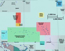 Kuria  Kuria  Kuria | |
| Geography | |
|---|---|
| Location | Pacific Ocean |
| Coordinates | 0°13′43″N 173°24′38″E |
| Archipelago | Gilbert Islands |
| Area | 15.48 km2 (5.98 sq mi) |
| Highest elevation | 3 m (10 ft) |
| Administration | |
Kiribati | |
| Demographics | |
| Population | 1,046 (2015 Census) |
| Pop. density | 63/km2 (163/sq mi) |
| Ethnic groups | I-Kiribati 100% |
Geography
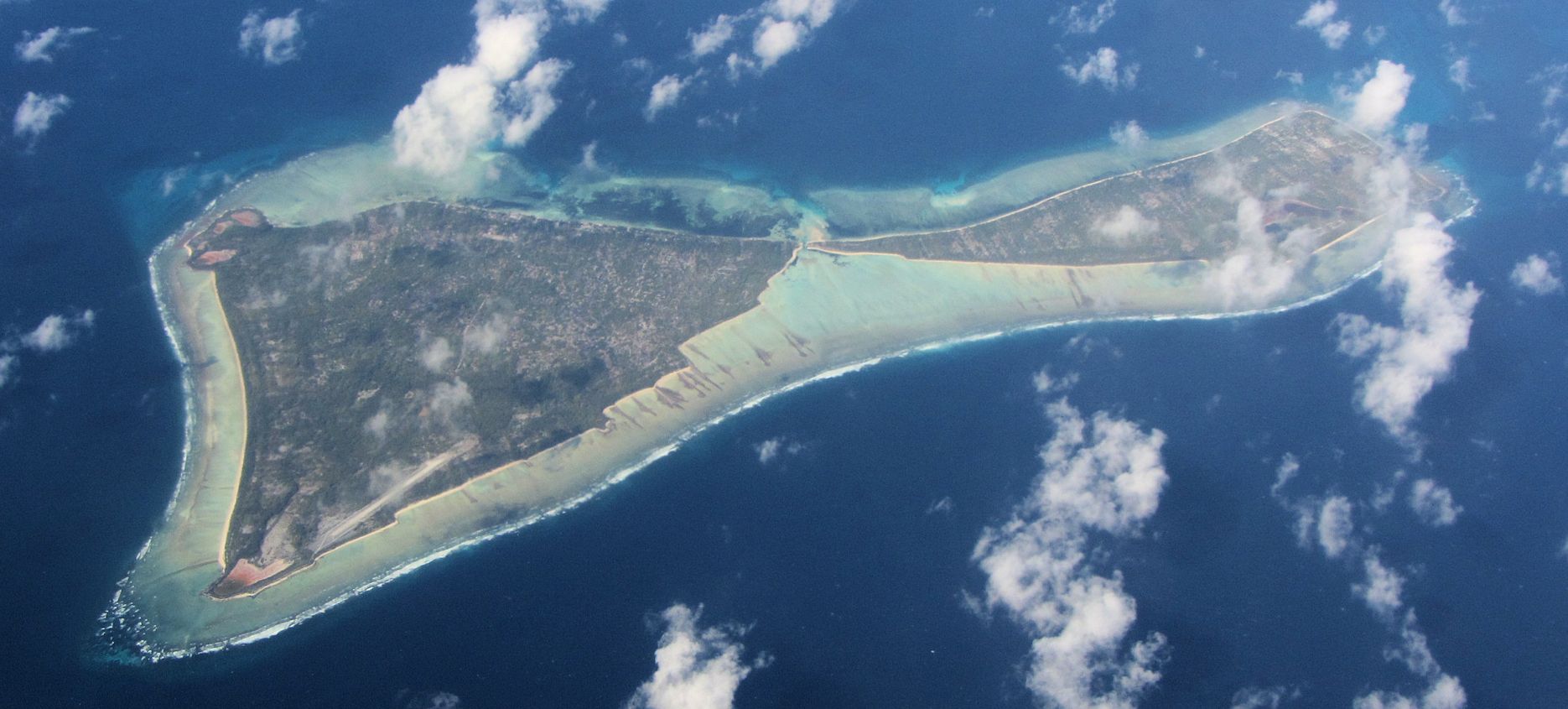
Kuria is made up of two islets, which are reef islands as they do not have a lagoon. The main islet, Buariki, has five villages; Marenaua, Bouatoa, Buariki, Tabontebike and Norauea. These villages are connected to the smaller islet of Oneeke by a ten-metre (33 ft) bridge replacing the old causeway that ran across the former reef passage between the two islets. The two islets are relatively wide as compared to most islands in the Gilbert group. The widest portion measures 4.26 km (2.65 mi) from lagoon to the ocean side and the length from north to south is 8.94 km (5.56 mi). There are two natural brackish-water ponds at east-southern tip of the main islet. The total land area of Kuria is of 15.48 km2 (5.98 sq mi), which is close to the average size for an island of Kiribati, but the population in 2010 was only 980 people, making Kuria one of the least densely populated islands in Kiribati.[1]
The main administration center is located at Buariki, and the airport, police headquarters, guest house and Junior Secondary School are also located here.[1]
Villages
| Kuria: Population and Land Area | |||
| Census Area | Population 2010[2] | Land area by islet[2] | Density (people per hectare) |
|---|---|---|---|
| Oneeke | 154 | 525 hectares (1,297 acres) | 0.3 |
| Manenaua | 191 | 1,022.7 hectares (2,527 acres) | 0.8 |
| Tabontebike | 91 | ||
| Buariki | 169 | ||
| Norauea | 247 | ||
| Bouatoa | 128 | ||
| Kuria total | 980 | 1,547.7 hectares (3,824 acres) | 0.6 |
History

Kuria means 'almost seen on the horizon'.[3][Note 1] Thomas Gilbert and John Marshall, sailing in the merchant ships Charlotte and Scarborough, were the first Europeans to describe visiting Kuria, in June 1788.[6]
The islands were surveyed in 1841 by the US Exploring Expedition.[7]
In the 1840s, the islands of Kuria and Aranuka were conquered by Tenkoruti or Karotu, the paramount chief or the Uea (king) of Abemama, when a former ruler (Ten Temea) of Kuria and Aranuka gave up these two islands to King Karotu from Abemama and left for Maiana, another of the Gilbert group.[3] In 1878 Tenkoruti's nephew, Tembinok' or Tem Binoka became the Uea.[3][8] He acquired firearms and manufactured goods from traders and he purchased a ship. To pay for his acquisitions he tightened his control over the 3 islands in order to increase his supply of coconuts and other produce, which he sold to the traders.[3] Tembinok' was immortalised by Robert Louis Stevenson's description of him in his book In the South Seas. Robert Louis Stevenson spent two months on Abemama in 1889. Stevenson described Tembinok' as the "one great personage in the Gilberts … and the last tyrant".[9]
In early European times, animals in Kuria were not considered a welcome addition to the ecosystem. As a result, introduced animals were considered a subject of supernatural fears and were slaughtered and thrown into the lagoon.[10]
Kuria Post Office opened around 1912.[11]
Tourism
Air Kiribati operates two flights per week from South Tarawa, linking with neighbouring Aranuka Airport. Boat charters are also available.
The Island Council operates a guest house, where tourists are welcome, although it is advisable to be prepared as the island is very isolated.
Dress code is restricted on Kuria. Casual wear is preferable and women are not allowed to walk around with bikinis, mini skirts or shorts. A skirt/short covered down to your knees or wrapped around lava-lava and T-shirts are preferable.[10]
Notes
- Sir Arthur Grimble, cadet administrative officer in the Gilberts from 1914 and resident commissioner of the Gilbert and Ellice Islands colony from 1926, recorded the myths and oral traditions of the Kiribati people. He wrote the best-sellers A Pattern of Islands (London, John Murray 1952,[4] and Return to the Islands (1957), which was republished by Eland, London in 2011, ISBN 978-1-906011-45-1. He also wrote Tungaru Traditions: writings on the atoll culture of the Gilbert Islands, University of Hawaii Press, Honolulu, 1989, ISBN 0-8248-1217-4.[5]
References
- "9. Kuria" (PDF). Office of Te Beretitent - Republic of Kiribati Island Report Series. 2012. Retrieved 28 April 2015.
- "Kiribati Census Report 2010 Volume 1" (PDF). National Statistics Office, Ministry of Finance and Economic Development, Government of Kiribati. Archived from the original (PDF) on 2013-09-30.
- Dr Temakei Tebano & others (August 2008). "Island/atoll climate change profiles - Kuria Atoll". Office of Te Beretitent - Republic of Kiribati Island Report Series (for KAP II (Phase 2). Archived from the original on November 6, 2011. Retrieved 28 April 2015.
- Grimble, Arthur (1981). A Pattern of Islands. Penguin Travel Library. Penguin Books. ISBN 0-14-009517-9.
- Grimble, Arthur (1989). Tungaru traditions: writings on the atoll culture of the Gilbert Islands. Penguin Travel Library. University of Hawaii Press. ISBN 978-0-8248-1217-1.
- Samuel Eliot Morison (1944-05-22). "The Gilberts & Marshalls: A distinguished historian recalls the past of two recently captured pacific groups". Life magazine. Retrieved 2009-10-14.
- Stanton, William (1975). The Great United States Exploring Expedition. Berkeley: University of California Press. pp. 245. ISBN 0520025571.
- Cahoon, Ben. Kiribati. World Statesmen.org.
- Robert Louis Stevenson (1896). In the South Seas, Part V, Chapter 1. Chatto & Windus; republished by The Hogarth Press.
- "Kuria factsheet" (PDF). Kiribati Tourism, Government of Kiribati.[permanent dead link]
- Premier Postal History. "Post Office List". Premier Postal Auctions. Retrieved 5 July 2013.
- Exhibit: The Alfred Agate Collection: The United States Exploring Expedition, 1838-1842 from the Navy Art Gallery
Geography of Kiribati | ||
|---|---|---|
| Gilbert Islands |  | |
| Phoenix Islands | ||
| Line Islands | ||
| West of Gilberts | ||
| Reefs |
| |
| ||
На других языках
[de] Kuria-Inseln
Kuria (früher auch: Woodle's Island)[2] ist ein Atoll mit zwei Inseln im nördlich des Äquators gelegenen Teil der zentralen Gilbertinseln im Archipel des heutigen Staates Kiribati im Pazifik. Es liegt nordwestlich des Aranuka-Atolls.- [en] Kuria (atoll)
[es] Kuria
Kuria es el nombre de un par de islas en el norte de las Islas Gilbert, pertenecientes a la República de Kiribati, en el océano Pacífico. Están localizadas al noroeste de Aranuka (en la cual existe una isla con el mismo nombre de la isla más grande de Kuria).[fr] Kuria (île)
Kuria est un atoll des Kiribati[1]. La première mention de cette île en français porte la forme Kouria (Revue coloniale, juin 1847).[it] Kuria
Kuria è un atollo formato da una coppia di isole nel nord dell'arcipelago delle Isole Gilbert nell'Oceano Pacifico. Fa parte della Repubblica di Kiribati.[ru] Куриа
Куриа (англ. Kuria) — атолл в северной части островов Гилберта в Тихом океане. Расположен в 12 км к северо-западу от атолла Аранука.Другой контент может иметь иную лицензию. Перед использованием материалов сайта WikiSort.org внимательно изучите правила лицензирования конкретных элементов наполнения сайта.
WikiSort.org - проект по пересортировке и дополнению контента Википедии