geo.wikisort.org - Island
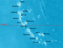
Tamana (also Rotcher Island) is the smallest island in the Gilbert Islands. It is accessible both by boat and by air with Air Kiribati and Coral Sun Airways (once a week; Tamana Airport code: TMN). 1,054 people live in Tamana (2020 census).
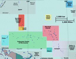
 Map of Tamana | |
 | |
 Tamana  Tamana  Tamana  Tamana | |
| Geography | |
|---|---|
| Location | Pacific Ocean |
| Coordinates | 2°30′S 175°59′E |
| Archipelago | Gilbert Islands |
| Administration | |
Kiribati | |
| Demographics | |
| Population | 1,054 (2020 Census) |
| Ethnic groups | I-Kiribati 100% |
Tamana is the second southernmost island in the Gilbert group and the smallest inhabited island in Kiribati. The island is approximately 6 km (4 mi) in length, 1 km (0.6 mi) at its widest point, and has a total land area of 4.73 km2 (1.83 sq mi).[1] Tamana is a reef island with no lagoon.
The Island Council is located at Bakaakaa, the central village of the island and this is also where the rest of the Government facilities are located such as the CB radio for inter-island communication, the hardware store, and the fuel depot. The schools (Primary and JSS) and the Medical facilities are also located in the same village.[1]
Myths and legends
The name Tamana is understood to mean ‘his/her father’; although in some myths it is understood to mean ‘a stronghold or strong place, or original settlement’.[2][Note 1]
History
In 1606, Spanish explorers became the first Europeans to discover the island.[5]
Tamana in September 1942 was the southernmost island touched by the Japanese occupation of the Gilbert Islands but Japanese troops did not occupy the atoll.
Tamana Post Office opened around 1915.[6]
Notes
- Sir Arthur Grimble, cadet administrative officer in the Gilberts from 1914 and resident commissioner of the Gilbert and Ellice Islands colony from 1926, recorded the myths and oral traditions of the Kiribati people. He wrote the best-sellers A Pattern of Islands (London, John Murray 1952,[3] and Return to the Islands (1957), which was republished by Eland, London in 2011, ISBN 978-1-906011-45-1. He also wrote Tungaru Traditions: writings on the atoll culture of the Gilbert Islands, University of Hawaii Press, Honolulu, 1989, ISBN 0-8248-1217-4.[4]
References
- "17. Tamana" (PDF). Office of Te Beretitent - Republic of Kiribati Island Report Series. 2012. Retrieved 28 April 2015.
- Dr Temakei Tebano & others (March 2008). "Island/atoll climate change profiles - Tamana Island". Office of Te Beretitent - Republic of Kiribati Island Report Series for KAP II (Phase 2). Archived from the original on November 6, 2011. Retrieved 28 April 2015.
- Grimble, Arthur (1981). A Pattern of Islands. Penguin Travel Library. Penguin Books. ISBN 0-14-009517-9.
- Grimble, Arthur (1989). Tungaru traditions: writings on the atoll culture of the Gilbert Islands. Penguin Travel Library. University of Hawaii Press. ISBN 978-0-8248-1217-1.
- "Tamana Island". Kiribati for Travellers. Retrieved 2021-03-16.
- Premier Postal History. "Post Office List". Premier Postal Auctions. Retrieved 5 July 2013.
- Exhibit: The Alfred Agate Collection: The United States Exploring Expedition, 1838-1842 from the Navy Art Gallery
На других языках
[de] Tamana (Insel)
Tamana ist die kleinste Insel im pazifischen Archipel der Gilbertinseln. Sie gehört zum Inselstaat Kiribati.- [en] Tamana, Kiribati
[es] Tamana (isla)
Tamana es la isla más pequeña del conjunto de las Islas Gilbert, pertenecientes a la República de Kiribati, en el océano Pacífico centroccidental. Tiene 4.8 km² de superficie y 875 habitantes en 2005.[fr] Tamana (Kiribati)
Tamana est un atoll des Kiribati, à l'extrême sud des îles Gilbert (seule Arorae est plus au sud). De petite taille (4,5 km2) (c'est la plus petite des îles Gilbert) et peuplée de 875 habitants en 2005, et de 1106 en 2015. Tamana est la seule île des Gilbert à ne pas avoir de lagon (avec Arorae qui a un minuscule lagon externe).[it] Tamana (Isole Gilbert)
Tamana è un'isola corallina appartenente all'arcipelago delle Isole Gilbert, situato nella Repubblica di Kiribati.[ru] Тамана (атолл)
Тамана (англ. Tamana) — атолл из одного моту в южной части островов Гилберта в Тихом океане. Расположен в 70 км к юго-востоку от атолла Онотоа и в 86 км к северо-западу от атолла Арораэ. В отличие остальных островов Кирибати, у данного атолла отсутствует лагуна.Другой контент может иметь иную лицензию. Перед использованием материалов сайта WikiSort.org внимательно изучите правила лицензирования конкретных элементов наполнения сайта.
WikiSort.org - проект по пересортировке и дополнению контента Википедии
