geo.wikisort.org - Island
Kuhn Island (Russian: Остров Куна; Ostrov Kuna) is an island in Franz Josef Land, Arkhangelsk Oblast, Russia.
Остров Куна | |
|---|---|
 Kuhn Island, within the Zichy Land islands | |
 Location of the Zichy Land subgroup of the Franz Josef Archipelago. Kuhn Island is located towards its eastern side. | |
| Geography | |
| Location | Arctic |
| Coordinates | 81.125444°N 58.392893°E |
| Archipelago | Franz Josef Archipelago |
| Area | 17.5 km2 (6.8 sq mi) |
| Highest elevation | 228 m (748 ft) |
| Administration | |
Russia | |
| Demographics | |
| Population | 0 |
Geography
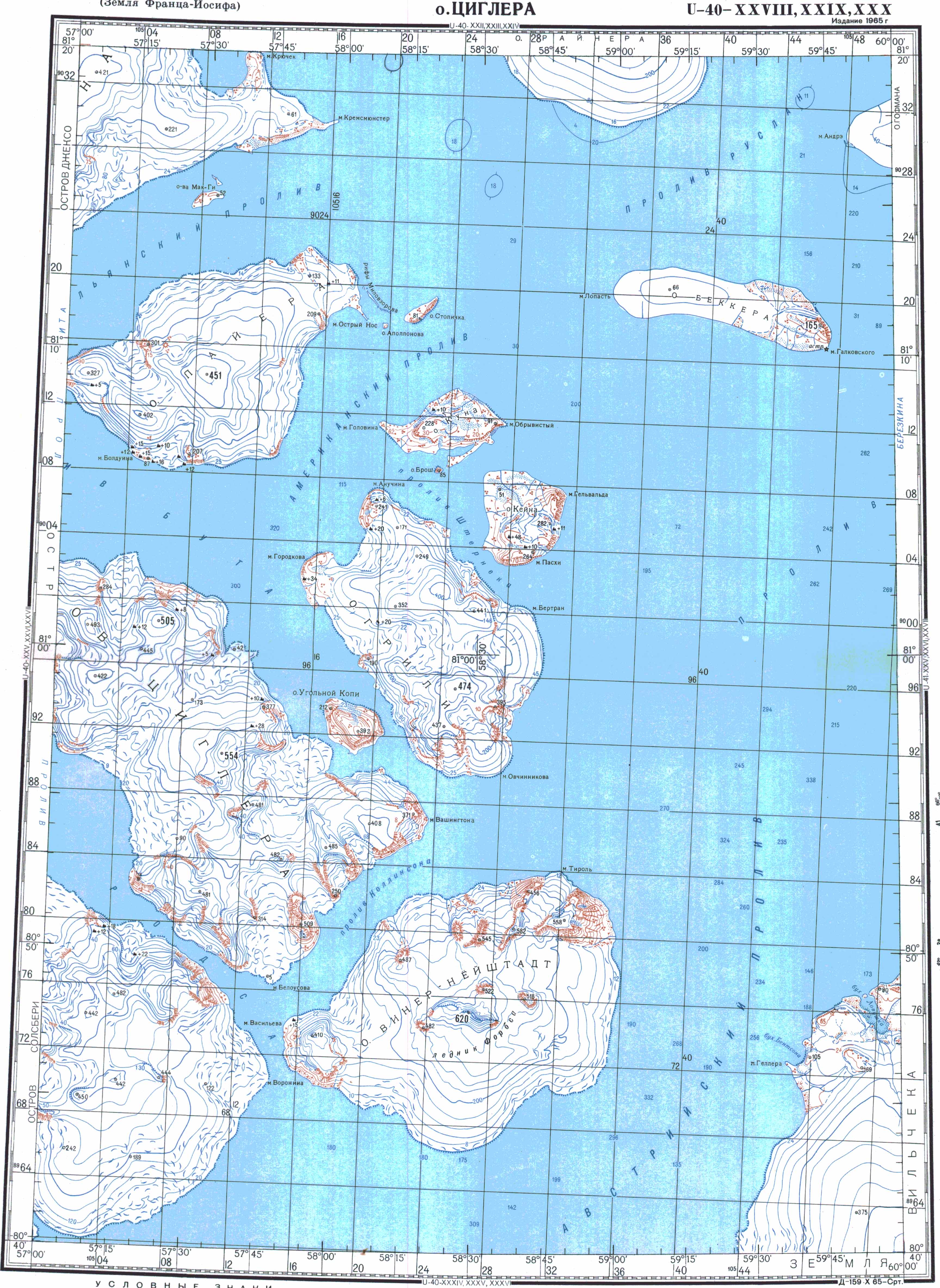
The island has a maximum altitude of 228 m (748 ft). Between its westernmost point, Cape Golovin (Russian: мыс Головина), and its easternmost point, Cape Obryvisty (Russian: мыс Обрывистый), it is about 8 km (5 mi) in length. Just south of Kuhn Island lies the small Brosch Island (Russian: Остров Брош, Ostrov Brosh) with a maximum height of 85 m (279 ft). Kane Island lies to the east. All three islands are separated from the larger Greely Island to the south by the Sternek Strait (Russian: пролив Штернека).[1]
History
The island was discovered by the Austro-Hungarian North Pole expedition in 1874 and was named in honour of the Austro-Hungarian minister of war Franz Kuhn von Kuhnenfeld, a patron of Julius Payer, one of the expedition's leaders.[2]
See also
References
- Циглер (1965). Topographical Map U-40-XXVIII,IXXX,XXX (Map). 1 : 200 000. Retrieved 3 January 2021.
- Payer, Julius (1875). "The Austro-Hungarian Polar Expedition of 1872-4". The Journal of the Royal Geographical Society of London. 45: 1–19. doi:10.2307/1798702. Retrieved 27 December 2020.
External links
This Arkhangelsk Oblast location article is a stub. You can help Wikipedia by expanding it. |
На других языках
[de] Kuhn-Insel (Franz-Josef-Land)
Die Kuhn-Insel (russisch Остров Куна; Ostrow Kuna) ist eine Insel des arktischen Franz-Josef-Lands. Administrativ gehört sie zur russischen Oblast Archangelsk.- [en] Kuhn Island (Franz Josef Land)
[it] Isola di Kuhn
L'isola di Kuhn (in russo Остров Куна, ostrov Kuna) è un'isola russa nell'Oceano Artico che fa parte della Terra di Zichy nell'arcipelago della Terra di Francesco Giuseppe.[ru] Остров Куна
Остров Куна — остров архипелага Земля Франца-Иосифа. Наивысшая точка острова — 228 метров. Административно относится к Приморскому району Архангельской области России.Другой контент может иметь иную лицензию. Перед использованием материалов сайта WikiSort.org внимательно изучите правила лицензирования конкретных элементов наполнения сайта.
WikiSort.org - проект по пересортировке и дополнению контента Википедии