geo.wikisort.org - Island
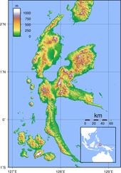
Halmahera, formerly known as Jilolo, Gilolo, or Jailolo, is the largest island in the Maluku Islands. It is part of the North Maluku province of Indonesia, and Sofifi, the capital of the province, is located on the west coast of the island.
 Coastline of Halmahera | |
 Small scale map of the island | |
 Halmahera | |
| Geography | |
|---|---|
| Location | South East Asia |
| Coordinates | 0°36′N 127°52′E |
| Archipelago | Maluku Islands |
| Area | 17,780 km2 (6,860 sq mi) |
| Area rank | 51st |
| Highest elevation | 1,560 m (5120 ft) |
| Highest point | Mount Gamkonora |
| Administration | |
| Province | |
| Largest settlement | Tobelo |
| Demographics | |
| Population | 449,938 (2010) |
| Pop. density | 25.3/km2 (65.5/sq mi) |
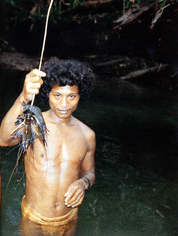
| Ethnic groups | Tobelo, Bugis, Togutil, Galela, Sahu, Waioli, Modole, Pagu, Kao Islam, Sawai, Gane, Buli, Maba, Loloda, Tabaru, Patani, Bicoli. Significant migrant groups include Sangir, Ternate, Tidore, Makian, and Javanese. |
Halmahera has a land area of 17,780 km2 (6,860 sq mi); it is the largest island of Indonesia outside the five main islands. It had a population of 162,728 in 1995; by 2010, it had increased to 449,938 for the island itself (excluding the tip which is considered part of the Joronga Islands, but including Gebe and Ju islands) and 667,161 for the island group (including all of South Halmahera and Tidore, but not Ternate).[1][2] Approximately half of the island's inhabitants are Muslim and half are Christian.
History
Sparsely-populated Halmahera's fortunes have long been closely tied to those of the smaller islands of Ternate and Tidore, both off its west coast. These islands were both the sites of major kingdoms in the era before Dutch East India Company colonized the entire archipelago.
During World War II, Halmahera was the site of a Japanese naval base at Kao Bay.
In 1999 and 2000, Halmahera was the site of violence that began as a purely ethnic dispute between residents of (mainly Christian) Kao and (entirely Muslim) Malifut sub-districts and then took on a religious nature as it spread through much of the North Moluccas, called the Maluku sectarian conflict. Thousands of people on Halmahera were killed in the fighting between religious militias. In June 2000, about five hundred people were killed when a ferry carrying refugees from the fighting on Halmahera sank off the northeast tip of Sulawesi island. Conspiracy theories about this event abound. A memorial to this tragedy can be found in Duma village in North Halmahera district.
Today, much transportation to the rest of Indonesia is through connections on the provincial capital, Ternate island although Tobelo, the largest town on Halmahera, also has direct ferry and cargo sea links to Surabaya and Manado.[citation needed]
Particularly, since the inauguration of the first ever directly elected Bupati (Regent or District Head), Tobelo is undergoing rapid development and is aiming at rivaling Ternate's historical dominance.[citation needed] As it is surrounded by flat land, Tobelo has the potential for expansion.[citation needed] Ternate is limited by its size, being a small island which can be driven around in forty-five minutes. Also, in 2010, the provincial government has moved the provincial capital from Ternate City to Sofifi, a small village on the Halmahera coast opposite Tidore island.
North Maluku Province consists of eight regencies and two municipalities (cities); five of the regencies and one municipality include a part of Halmahera island. The regencies are North Halmahera, West Halmahera, East Halmahera, Central Halmahera, South Halmahera, Morotai, Sula Islands and Taliabu, while the municipalities are Ternate and Tidore Islands. Only Ternate Municipality, and Morotai, the Sula Islands and Taliabu regencies do not include any part of Halmahera.
Geology
The volcanic island lies on an island arc that includes the Raja Ampat Islands, all uplifted by the northward migration of the continent of Australia and subduction of the Pacific Plate. Dukono is an active volcano at the north end of the island. Mount Ibu is an active volcano on the island's northwest coast.
Ecology
The flightless invisible rail is endemic to the island.[3] The recently discovered palm tree Jailoloa halmaherensis is also endemic to Halmahera.[4]
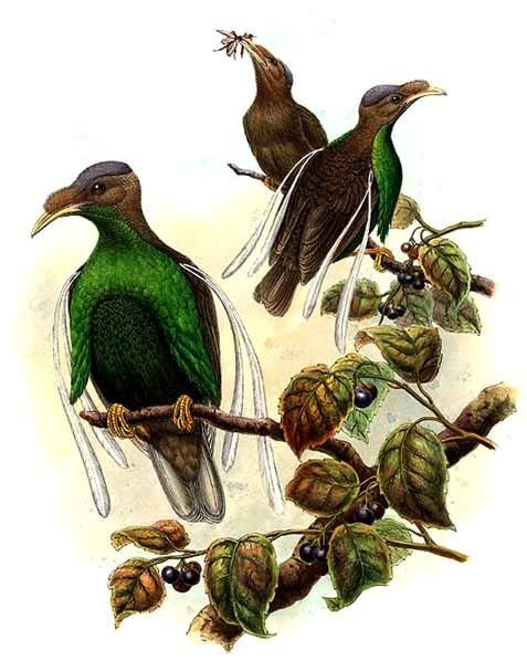
The naturalist Alfred Russel Wallace visited Halmahera, as described in his 1869 book The Malay Archipelago. He considered the standardwing bird of paradise, Semioptera wallacei, to be his greatest prize.[5] It was in February 1858, on the island of Ternate, between bouts of fever, that a suffering Wallace came to the idea of natural selection via the survival of the fittest. Wallace wrote his ideas during the next couple of days, and sent the historical letter to Darwin.
Mining
Halmahera is the site of several mining projects.
PT Weda Bay Nickel operates a nickel and cobalt mining project in North and Central Halmahera Regencies, the Weda Bay Industrial Park.
Image gallery
 A Weda Bay nickel camp site at Tanjung Ulie cape on Halmahera island
 A rig crew looking for minerals


References
- "Indonesia: Administrative Division (Provinces, Regencies and Cities) - Population Statistics, Charts and Map". www.citypopulation.de. Retrieved 11 April 2018.
- "Penduduk Halsel". Archived from the original on 2013-10-04. Retrieved 2013-07-01.
- BirdLife International (2016). "Habroptila wallacii". IUCN Red List of Threatened Species. 2016: e.T22692781A93369321. doi:10.2305/IUCN.UK.2016-3.RLTS.T22692781A93369321.en. Retrieved 11 November 2021.
- Heatubun, Charlie D.; Zona, Scott; Baker, William J. (2014). "Three new genera of arecoid palm (Arecaceae) from eastern Malesia". Kew Bulletin. 69 (3). doi:10.1007/s12225-014-9525-x. S2CID 24848021.
- "Halmahera and Wallace's Greatest Prize: The Standardwing Bird of Paradise". Wallace Fund. Archived from the original on 24 September 2018. Retrieved 1 April 2015.
External links
 Media related to Halmahera at Wikimedia Commons
- Folk Orientation in Halmahera[permanent dead link]
Regencies and cities of North Maluku | ||
|---|---|---|
Capital: Sofifi | ||
| Regencies | ||
| Cities | ||
Authority control | |
|---|---|
| General | |
| National libraries | |
| Other | |
На других языках
[de] Halmahera
Halmahera (veraltet Gilolo) ist eine indonesische Insel. Sie ist mit einer Fläche von 18.040 km² die größte Insel der Inselgruppe der Molukken und Teil der Provinz Maluku Utara. Die Stadt Sofifi an der Westküste ist der Hauptort der Provinz.- [en] Halmahera
[es] Halmahera
La isla de Halmahera (o Gilolo o Jailolo) es la mayor isla del archipiélago de las Molucas. Forma parte de la provincia indonesia de Molucas del Norte, Sofifi, la capital de la provincia se encuentra en la costa oeste de la isla.[fr] Halmahera
Halmahera, aussi appelée Gilolo ou Jilolo est une île du nord-est de l’Indonésie dans l'archipel des Moluques. Elle est la plus grande des Moluques avec une superficie de 17 780 km2. Elle est située sur l'équateur et compte environ 180 000 habitants.[it] Halmahera
Halmahera (chiamata anche Jilolo o Gilolo) è l'isola maggiore dell'arcipelago delle Molucche, nell'oceano Pacifico. Politicamente, fa parte della provincia di Maluku Settentrionale, in Indonesia.[ru] Хальмахера (остров)
Хальмахе́ра[1], (устар. Джайло́ло[2], Джилоло,[3][4], Гальмагера[3][4], Галмагейра[5]) (индон. Pulau Halmahera) — остров в Малайском архипелаге, крупнейший из Молуккских островов, принадлежит Индонезии.Другой контент может иметь иную лицензию. Перед использованием материалов сайта WikiSort.org внимательно изучите правила лицензирования конкретных элементов наполнения сайта.
WikiSort.org - проект по пересортировке и дополнению контента Википедии