geo.wikisort.org - Island
Saparua is an island east of Ambon Island in the Indonesian province of Maluku; the island of Haruku lies between Saparua and Ambon. The main port is in the south at Kota Saparua. The island of Maolana is located near its southwestern side and Nusa Laut off its southeastern tip.[1]
 Location of Saparua | |
 Saparua is in the center of the map, just south of Seram. | |
| Geography | |
|---|---|
| Location | South East Asia |
| Archipelago | Maluku Islands |
| Area | 168.1 km2 (64.9 sq mi) |
| Highest elevation | 360 m (1180 ft) |
| Highest point | Takuku |
| Administration | |
Indonesia | |
| Province | Maluku |
| Regency | Central Maluku |
| Demographics | |
| Population | 36,022 (2020 Census) |
| Pop. density | 214.3/km2 (555/sq mi) |
Saparua was administered as a single eponymous district (kecamatan) of Central Maluku Regency (Kabupaten Maluku Tengah), but in 2012 an additional district of East Saparua was formed from the eastern peninsula of the original district. Kota Saparua (Saparua town) is the administrative centre of the residual (western) district, while Tuhaha is the administrative centre of the new district.
The island (including Maolana) covers a land area of 168.1 km2, and had a population of 32,312 as of the 2010 census[2] and 36,022 at the 2020 Census.[3] The inhabitants of Saparua speak the Saparua language, as well as Indonesian and Ambonese Malay.[4]
Saparua was the location of Indonesian national hero, Pattimura's rebellion against Dutch forces in 1817. It was also the birthplace of G.A. Siwabessy, a prominent politician who was Indonesia's Minister of Health during the 1960s and 1970s.
Villages on Saparua
There are 17 administrative villages, listed below with their populations at the 2020 Census;[5] ten comprise the new district of East Saparua, while seven remain with the existing Saparua district
- Saparua (3,198)
- Tiouw (1,484)
- Paperu (1,412)
- Booi (927)
- Haria (7,461)
- Portho (2,808)
- Kulur (1,112)
Saparua Timur
- Ouw (1,680)
- Ullath (1,591)
- Siri-sori Amapatti (2,002)
- Siri-sori Amalatu (2,251)
- Tuhaha (2,379)
- Ihamahu (1,509)
- Iha (391)
- Noluth-Titasomi (3,038)
- Itawaka (2,060)
- Mahu (718)
Gallery
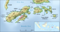 Saparua is in the right of the map, east of Haruku Island.
 Kota Saparua from Fort Duurstede
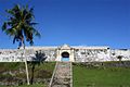 Fort Duurstede at Saparua
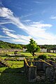 The inside of Fort Duurstede, Saparua


References
- Prostar Sailing Directions 2004 New Guinea Enroute. ProStar Publications. 2004. p. 47. ISBN 978-1-57785-569-9.
- Indonesia - Maluku Census
- Badan Pusat Statistik, Jakarta, 2021.
- Saparua - Ethnologue
- Biro Pusat Statistik, Jakarta, 2021.
External links
 Media related to Saparua at Wikimedia Commons
This article about a location in Maluku Province is a stub. You can help Wikipedia by expanding it. |
На других языках
[de] Saparua
Saparua (indonesisch Pulau Saparua) ist eine 161 km²[2] große indonesische Insel im Südwesten von Seram in der Provinz Maluku und gehört zu den Lease-Inseln.- [en] Saparua
[fr] Saparua
Saparua est une petite île à l'est de Haruku dans la province indonésienne des Moluques. Sa superficie est de 190 km². Sa population est de 32312 habitants, suivant le recensement de 2010.Другой контент может иметь иную лицензию. Перед использованием материалов сайта WikiSort.org внимательно изучите правила лицензирования конкретных элементов наполнения сайта.
WikiSort.org - проект по пересортировке и дополнению контента Википедии