geo.wikisort.org - Island
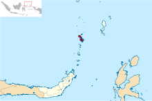
The Sangihe Islands (also spelled "Sangir", "Sanghir" or "Sangi") – Indonesian: Kepulauan Sangihe – are a group of islands which constitute two regencies within the province of North Sulawesi, in northern Indonesia, the Sangihe Islands Regency (Kabupaten Kepulauan Sangihe) and the Sitaro Islands Regency (Kabupaten Siau Tagulandang Biaro). They are located north-east of Sulawesi between the Celebes Sea and the Molucca Sea, roughly halfway between Sulawesi and Mindanao, in the Philippines; the Sangihes form the eastern limit of the Celebes Sea.[1] The islands combine to total 813 square kilometers (314 sq mi), with many of the islands being actively volcanic with fertile soil and mountains.
This article needs additional citations for verification. (November 2010) |

The main islands of the group are, north to south, Sangir Besar (or Sangir Island), Siau (or Siao), Tahulandang, and Biaro. The largest island is Sangir Besar and contains an active volcano, Mount Awu (1,320 meters (4,330 ft)). Tahuna is the chief town and port, also hosting the islands' sole airport, Naha Airport.
The area came under Dutch control in 1677, and became part of Indonesia when it declared independence from the Netherlands in 1945.
The Sangir language is spoken in the islands; this Austronesian language is also spoken in some islands in the Philippines, and on the extreme northern tip of Sulawesi.[2]
The Sangihe tectonic plate is named after the island arc and is very active.[further explanation needed]
In 2007, the Sitaro Islands (named for its three largest islands - SIau island, TAgulandang island and BiaRO island) became a new regency by separation from the Sangihe Islands. The population for these island groups was 189,676 at the 2010 Census, comprising 126,133 in the Sangihe Islands Regency and 63,543 in the Sitaro Islands Regency.
Marore Island
Marore Island is one of the coordinate points in the Sangihe Islands used to determine the baselines of Indonesia. 15 years ago the practice of illegal fish bombing damaged the coral and mangrove ecosystems. In 2012, recovery of coral was observed, but not yet for mangrove.[3]
See also
- List of extinct birds
Notes
| Wikimedia Commons has media related to Sangihe Islands. |
This North Sulawesi location article is a stub. You can help Wikipedia by expanding it. |
На других языках
[de] Sangihe-Inseln
Die Sangihe-Inseln oder Sangir-Inseln (indonesisch Kepulauan Sangihe) sind eine Gruppe von etwa 50 bergigen und vulkanischen Inseln im nördlichen Indonesien, nordöstlich von Sulawesi an der Grenze von Celebessee und Molukkensee,[1] ungefähr auf dem halben Weg zwischen Sulawesi und Mindanao in den Philippinen.- [en] Sangihe Islands
[fr] Îles Sangihe
Les îles Sangihe, en indonésien Kepulauan Sangihe, forment un archipel d'Indonésie.[it] Isole Sangihe
Le Isole Sangihe (indonesiano: Kepulauan Sangihe ) è un gruppo di isole indonesiane.[ru] Сангихе
Санги́хе, устар. Санги́р[2] (индон. Sangihe, Sangir, Sanghir) — архипелаг у северо-восточной оконечности полуострова Минахаса, образующего северную часть индонезийского острова Сулавеси. Иногда наряду с соседней группой островов Талауд рассматривается как часть более крупного архипелага Сангихе-Талауд.Другой контент может иметь иную лицензию. Перед использованием материалов сайта WikiSort.org внимательно изучите правила лицензирования конкретных элементов наполнения сайта.
WikiSort.org - проект по пересортировке и дополнению контента Википедии