geo.wikisort.org - Coast
Ponta do Sinó is the southernmost point of the island of Sal in Cape Verde.[1] It lies 2 km southwest of Santa Maria city centre. The area north of the headland is a protected area: nature reserve Ponta do Sinó, at the edge of a large tourism development zone.[2] There is a lighthouse on the headland, Farol da Ponta do Sinó, built in 1892.[3][4]

Ponta do Sinó | |
|---|---|
 The lighthouse and the headland facing about southwest and the point | |
 Ponta do Sinó | |
| Coordinates: 16°35′06″N 22°55′16″W | |
| Location | Southern Sal, Cape Verde near Santa Maria |
| Offshore water bodies | Atlantic Ocean |
See also
- Tourism in Cape Verde
References
- Cabo Verde, Statistical Yearbook 2015, Instituto Nacional de Estatística, p. 26
- Reservas Naturais, Áreas protegidas Cabo Verde
- List of Lights, Pub. 113: The West Coasts of Europe and Africa, the Mediterranean Sea, Black Sea and Azovskoye More (Sea of Azov) (PDF). List of Lights. United States National Geospatial-Intelligence Agency. 2018. p. 426.
- Rowlett, Russ. "Lighthouses of Cape Verde". The Lighthouse Directory. University of North Carolina at Chapel Hill. Retrieved 15 August 2018.
The island of Sal, Cape Verde | ||
|---|---|---|
| Settlements | 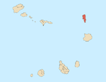 | |
| Mountains and hills |
| |
| Points and promontories | ||
| Lighthouses |
| |
| Other geographical features |
| |
| Other topics |
| |
Текст в блоке "Читать" взят с сайта "Википедия" и доступен по лицензии Creative Commons Attribution-ShareAlike; в отдельных случаях могут действовать дополнительные условия.
Другой контент может иметь иную лицензию. Перед использованием материалов сайта WikiSort.org внимательно изучите правила лицензирования конкретных элементов наполнения сайта.
Другой контент может иметь иную лицензию. Перед использованием материалов сайта WikiSort.org внимательно изучите правила лицензирования конкретных элементов наполнения сайта.
2019-2026
WikiSort.org - проект по пересортировке и дополнению контента Википедии
WikiSort.org - проект по пересортировке и дополнению контента Википедии