geo.wikisort.org - River
The Valdivia River or Río Valdivia, as it is known locally, is a major river in southern Chile. It is the continuation of the Calle-Calle River, from the point where it meets the Cau-Cau River in the city of Valdivia. The Valdivia river ends in Corral Bay, on the Pacific coast. Other tributaries are the Cruces River, the Tornagaleones River and the Futa River. Pedro de Valdivia Bridge crosses the river in downtown Valdivia.
| Valdivia River (Río Valdivia) | |
|---|---|
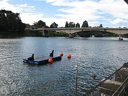
 View of the upper course of Valdivia River. Pedro de Valdivia Bridge is seen in the background. | |
 Map of the mouth of the Valdivia | |
| Location | |
| Country | Chile |
| Physical characteristics | |
| Source | |
| • location | Calle-Calle River, Caucau River |
| Mouth | |
• location | Corral Bay, Pacific Ocean |
• coordinates | 39°52′37″S 73°22′56″W |
• elevation | 0 m (0 ft) |
| Length | 15 km (9.3 mi)[1] |
| Basin size | 10,275 km2 (3,967 sq mi)[1] |
| Discharge | |
| • average | 687 m3/s (24,300 cu ft/s)[2] |
| Basin features | |
| Basin population | 168,489[1] |
References
- "Cuenca del río Valdivia" (PDF). Archived from the original (PDF) on 2007-09-27. Retrieved 2007-10-28.
- "Hidrografía Región de los Ríos". Biblioteca del Congreso Nacional de Chile (in Spanish). Archived from the original on 2022-03-04. Retrieved 2022-03-02.
External links
На других языках
[de] Río Valdivia
Der Río Valdivia (Valdivia-Fluss) entsteht in der südchilenischen Stadt Valdivia durch den Zusammenschluss des von Südosten kommenden Río Calle Calle und des kanalähnlichen, von Norden einmündenden Río Cau Cau östlich der Isla Teja.- [en] Valdivia River
[es] Río Valdivia
El río Valdivia es un corto curso natural de agua de Chile que discurre por la Región de Los Ríos.[ru] Вальдивия (река)
Вальди́вия (исп. Río Valdivia) — короткая река у побережья Чили в XIV области Лос-Риос. Длина — 15[1] км. Площадь бассейна — 10275[1] км².Текст в блоке "Читать" взят с сайта "Википедия" и доступен по лицензии Creative Commons Attribution-ShareAlike; в отдельных случаях могут действовать дополнительные условия.
Другой контент может иметь иную лицензию. Перед использованием материалов сайта WikiSort.org внимательно изучите правила лицензирования конкретных элементов наполнения сайта.
Другой контент может иметь иную лицензию. Перед использованием материалов сайта WikiSort.org внимательно изучите правила лицензирования конкретных элементов наполнения сайта.
2019-2025
WikiSort.org - проект по пересортировке и дополнению контента Википедии
WikiSort.org - проект по пересортировке и дополнению контента Википедии