geo.wikisort.org - River
Calle-Calle River, also called Gudalafquén in Mapuche language, is a river in Valdivia Province, southern Chile. It drains waters from the San Pedro River to the Valdivia River, which in turn flows into Corral Bay on the Pacific Ocean.
| Calle-Calle River Gudalafquén (Mapudungun) | |
|---|---|
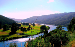 View of Calle-Calle River a few kilometers upstream from Valdivia | |
| Native name | Río Calle-Calle (Spanish) |
| Location | |
| Country | Chile |
| Physical characteristics | |
| Source | |
| • location | San Pedro River |
| Mouth | |
• location | Valdivia River |
| Length | 55 km (34 mi)[1] |
The River owes its current name to the Mapuche word for the flower Libertia chilensis.[2]
The Calle-Calle is among the few rivers in Chile that are considered navigable. The Calle-Calle and Santa Elvira bridges crosses the river in the city of Valdivia.
The city of Valdivia obtains most of its water supply from Calle-Calle River near Cuesta Soto. Decreasing precipitations has caused the city's water supply in Calle-Calle River to be contaminated with saline water from the coast.[3] The effects of saline water entering the water supply of Valdivia were particularly noticeable in 2015 when there was a surge in complains about the taste of the water.[3][4] The saltwater in the rivers near Valdivia during autumn is expected to increase in the future.[4] Estimations indicate that whenever the sum of the water discharge of Cruces and Calle-Calle rivers falls below 74 m3/s (2,600 cu ft/s) saltwater reaches the supply site at Cuesta Soto.[4]

References
- "Cuenca del río Valdivia" (PDF). Archived from the original (PDF) on 2007-09-27. Retrieved 2007-10-28.
- "Historia". Museo de Sitio Castillo de Niebla (in Spanish). Servicio Nacional del Patrimonio Cultural. Retrieved 2021-04-01.
- Jara, Yonatan; Stuardo, Manuel (2020-09-21). "Científicos proyectan en 80 años la llegada de mar a toma de agua en Valdivia para buscar soluciones". Radio Bío-Bío (in Spanish). Retrieved 2022-03-07.
- Lara, Emilio (2020-09-16). "El mar se acerca a principal toma de agua dulce en Valdivia y amenaza calidad del recurso". Radio Bío-Bío (in Spanish). Retrieved 2022-03-07.
| Authority control |
|
|---|
This Los Ríos Region location article is a stub. You can help Wikipedia by expanding it. |
На других языках
- [en] Calle-Calle River
[es] Río Calle-Calle
El río Calle-Calle de Chile empieza en el poblado de Calle Calle, localidad ubicada en los límites de las comunas de Valdivia y Los Lagos y termina en la ciudad de Valdivia, donde pasa a llamarse río Valdivia luego de unirse al río Cau-cau. Poco antes de que cambie de nombre es atravesado por el Puente Calle-Calle, que es la conexión directa desde la ciudad hacia el norte del país.[ru] Кальекалье
Кальекалье[1][2] (исп. Río Calle-Calle, от мап. calle множество растений семейства ирисовых) — это река в провинции Вальдивия на юге Чили. Истоком служит река Сан-Педро. Впадает в реку Вальдивия. Длина 55 км[3]. Площадь водосборного бассейна — 5267 км².[источник не указан 1239 дней]Другой контент может иметь иную лицензию. Перед использованием материалов сайта WikiSort.org внимательно изучите правила лицензирования конкретных элементов наполнения сайта.
WikiSort.org - проект по пересортировке и дополнению контента Википедии