geo.wikisort.org - River
The Ugar (Serbian Cyrillic: Угар, known as the Brzica until 1878)[1] is a river of Bosnia, a tributary of the Vrbas river. It originates at the slopes of Vlašić, upstream of Sažići and Melina villages (at around of 1590 meters above sea level), a watershed area of Vrbanja, Ilomska and Bila rivers. The valley along the Ugar is known as Pougarje.

| Ugar Brzica | |
|---|---|
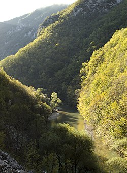
 Ugar river, at the bottom of its deep canyon | |
 Ugar river in Bosnia and Herzegovina | |
| Location | |
| Country | Bosnia and Herzegovina |
| Canton | Srednja Bosna |
| Physical characteristics | |
| Source | |
| • location | Prelivode, Vlašić Mt. |
| • coordinates | 44°20′38″N 17°39′22″E |
| • elevation | ~1,590 m (5,220 ft) |
| Mouth | |
• location | Vrbas |
• coordinates | 44°27′12″N 17°14′20″E |
• elevation | 268 m (879 ft) |
| Length | 44.5 km (27.7 mi) |
| Basin size | 328 km2 (127 sq mi) |
| Discharge | |
| • location | Mouth |
| • average | 6.98 m3/s (246 cu ft/s) |
| Basin features | |
| Progression | Vrbas→ Sava→ Danube→ Black Sea |
| Tributaries | |
| • right | Ugrić, Pljačkovac, Ilomska, Kobilja, Zirin potok, Kusin potok |
| Waterfalls | several |
Geography and hydrology
The Ugar's length is around 44.5 kilometres, and its catchment is around 328 km2. Its largest right tributaries are: Pljačkovac, Ilomska, Kobilja, Zirin Potok and Kusin Potok (Ziro's and Kuso's creeks), and Ugrić; left tributaries are the creeks: namely Lužnica Potok, Dedića Potok, Andrijevića Potok, Bunar, Oraški Potok, and Kukavički Potok.[2][3][4]
At its source Ugar and its headwaters tributaries creates series of waterfalls. After short, but deep canyon (below the Babanovac plateau) it enters into Pougarje, under the Ranča Mountain. By this, Ugar flows into a deep and long canyon under Skender Vakuf, around 20 kilometres downstream of Jajce. Notch of the Canyon is a very arduous and its maximal depth is (approximately) 500 m. The area in the valley along the Ugar, from Vitovlje to its Canyon is marked as Pougarje[5]
The area along the Ugar is known as Pougarje. Pougarje extends from the Vitovlje village to the Ugar's entrance into the canyon below Skender Vakuf. It is located between Ranča Mountain (left) and rock's massif Korićanske stijene - Ugarske stijene (Ugar's rocks).[6] From Vitovlje to Ugar's canyon it is known as the Lower (Donje) Pougarje, while the area on Ranča's slopes is Upper (Gornje) Pougarje.[7][8][2][9]
The valley (especially the slopes of Ranča) is rich in coniferous and mixed deciduous-coniferous forests. The upper and middle part of the basin in the area still has the character of a salmonid water, now there are only (brown trout), while the huchen and grayling have disappeared in the recent past. The surrounding forests are inhabited by the big game (fox, wolf, bear, wild boar, and the others). At in a brushwood at the mouth of the Ilomska, in a protected hunting area, there is feeding place for carnivores (including corvine shoals).
See also
References
- Džaja M. (1995): Pougarje i njegova okolica. Monografija.
- "Karta BiH - Karta Bosne i Hercegovine". kartabih.com. Retrieved 2014-08-06.
- Spahić M. et al. (2000): Bosna i Hercegovina (1:250.000). Izdavačko preduzeće „Sejtarija“, Sarajevo.
- Mučibabić B., Ed. (1998): Geografski atlas Bosne i Hercegovine. Geodetski zavod BiH, Sarajevo.
- Vojnogeografski institut, Ed.. (1955): Travnik (List karte 1:100.000, Izohipse na 20 m). Vojnogeografski institut, Beograd.
- Džaja M. (1995): Pougarje i njegova okolica. Monografija. (Pougarje and its surroundings. Monograph.)
- Vojnogeografski institut, Ed. (1955): Travnik (List karte 1:100.000, Izohipse na 20 m). Vojnogeografski institut, Beograd.
- Spahić M. et al. (2000): Bosna i Hercegovina (1:250.000). Izdavačko preduzeće „Sejtarija“, Sarajevo.
- Mučibabić B., Ed. (1998): Geografski atlas Bosne i Hercegovine. Geodetski zavod BiH, Sarajevo.
На других языках
[de] Ugar (Fluss)
Der Ugar (serbisch-kyrillisch Угар; bis 1878 Brzica[1]) ist ein rechter Nebenfluss des Vrbas in Bosnien und Herzegowina. Er entspringt – so wie Vrbanja, Ilomska und Bila – auf dem Vlašić in einem Gebiet namens Prelivode. Der Fluss ist etwa 44,5 km lang, sein Einzugsgebiet umfasst 328 km2. Rechte Zuflüsse sind Pljačkovac, Ilomska, Kobilja, Zirin potok, Kusin potok und Ugrić; von linker Seite fließen Lužnica, Dedića i Andrijevića potok, Bunar, Oraški und Kukavički potok zu.- [en] Ugar (river)
Другой контент может иметь иную лицензию. Перед использованием материалов сайта WikiSort.org внимательно изучите правила лицензирования конкретных элементов наполнения сайта.
WikiSort.org - проект по пересортировке и дополнению контента Википедии
