geo.wikisort.org - Reservoir
Jablaničko lake (Bosnian: Jablaničko jezero) is a large artificially formed lake on the Neretva river, right below Konjic where the Neretva expands into a wide valley. The river provided lot of fertile, agricultural land there, before the lake flooded most of it. The lake was created in 1953 after construction of[1] Jablanica Dam near Jablanica in central Bosnia and Herzegovina.
| Jablaničko Lake | |
|---|---|
 | |
 Jablaničko Lake | |
| Location | North Herzegovina |
| Coordinates | 43°41′N 17°51′E |
| Type | reservoir |
| Primary inflows | Neretva |
| Primary outflows | Neretva |
| Basin countries | Bosnia and Herzegovina |
| Max. length | 30 km (19 mi) |
| Max. width | 1,200 m (3,900 ft) |
| Surface area | 24 km2 (9.3 sq mi) |
| Average depth | 70 m (230 ft) |
| Max. depth | 80 m (260 ft) |
| Surface elevation | 270 m (890 ft) |
| Settlements | Jablanica, Konjic, Prozor-Rama |
The lake has an irregular elongated shape. Its width varies along its length. The lake is a popular vacation destination in Bosnia and Herzegovina. Swimming, boating, and especially fishing are popular activities on the lake. Many weekend cottages have been built along the shores of the lake. There are 13 types of fish in the lake's ecosystem.
However, the lake suffered from poor management of water and fisheries. Without any scientific and management plans or research, local fisheries and angling management introduced, alien, non-indigenous or non-native species, either deliberately or accidentally, which did more harm and damage than good. As the Neretva has many endemic and fragile species of fish that are near extinction, introductions of this invasive species, Pike Perch (Stizostedion lucioperca L.), completely destroyed native endemic and highly endangered fish like Strugač (Leuciscus svallize svallize Heck. et Kn.) or (Squalius svallize)[2] and Glavatica (Salmo marmoratus) (also known as Gonjavac).[3]
Gallery
 Boat at Jablaničko lake
 Jablanica lake at summer
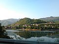 Jablanicko Jezero
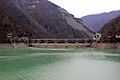 Jablanica dam


See also
Water bodies
- Neretva
- Upper Neretva
- Rakitnica
- Mostarska Bijela
- Buna
- Bunica
- Trebižat
- Bregava
- Krupa River
- Trebišnjica
Settlements
- Ulog
- Glavatičevo
- Lukomir
- Jablanica
- Mostar
- Blagaj
- Stolac
- Čapljina
Protected environment and treasures
- Blidinje
- Stari most (Old Bridge)
- Vrelo Bune
- Počitelj
- Hutovo Blato
- Livanjsko field
- List of birds of BiH
- List of national parks of BiH
Nature and culture
- Salmo obtusirostris
- Salmo dentex
- Salmo marmoratus
- Environmental impacts of dams
- Vajont Dam
- Environment and electricity generation
- Tourism in Bosnia and Herzegovina
References
- "Methodology and Technical Notes". IUCN - Watersheds of the World. Archived from the original on 2007-07-04. Retrieved 2009-07-15.
A large dam is defined by the industry as one higher than 15 meters high and a major dam as higher than 150.5 meters
- "Fishbase - Species Summary: Strugač". Fishbase. Retrieved 2009-07-14.[permanent dead link]
- "Living Neretva - biodiverzitet". WWF Panda. Retrieved 2009-07-14.
Neretva river basin | |||||||||||||||||
|---|---|---|---|---|---|---|---|---|---|---|---|---|---|---|---|---|---|
| Countries |
|   | |||||||||||||||
| Places | |||||||||||||||||
| Wellsprings | |||||||||||||||||
| Tributaries |
| ||||||||||||||||
| Lakes |
| ||||||||||||||||
| Hydroelectric Power Plants |
| ||||||||||||||||
| Related articles |
| ||||||||||||||||
| Trebišnjica drainage: sub-basin of the Neretva |
| ||||||||||||||||
Hydrography of Bosnia and Herzegovina | |||||||
|---|---|---|---|---|---|---|---|
| Rivers |
| | |||||
| Lakes |
| ||||||
| Valleys & canyons |
| ||||||
| Wetlands |
| ||||||
| Waterfalls |
| ||||||
На других языках
[de] Jablaničko jezero
Der Jablaničko jezero ist ein Stausee der Neretva im Norden des Kantons Herzegowina-Neretva in Bosnien und Herzegowina. Bei Vollstau liegt die Wasseroberfläche des Sees auf 270 m über dem Meeresspiegel. Der See hat dann eine Fläche von 13,3 km², ist etwa 30 km lang und bis zu 70 m tief. Er liegt zwischen den Städten Jablanica und Konjic, auf deren Gemeindegebiet er auch liegt.- [en] Jablaničko lake
[fr] Lac de Jablanica
Le lac de Jablanica (en serbe : Jablaničko jezero) est un lac artificiel créé en 1953 et localisé au centre de la Bosnie-Herzégovine. Les localités proches sont Konjic et Jablanica. En 2017, il a perdu la quasi-totalité de sa superficie.[ru] Ябланица (водохранилище)
Ябланица[1] (босн. Jablaničko jezero) — водохранилище в центральной части Боснии и Герцеговины. Создано в 1953 году, после строительства плотины гидроэлектростанции на реке Неретва. Площадь водного зеркала — 14,15 км²[2]. Высота над уровнем моря — 263 м[2].Другой контент может иметь иную лицензию. Перед использованием материалов сайта WikiSort.org внимательно изучите правила лицензирования конкретных элементов наполнения сайта.
WikiSort.org - проект по пересортировке и дополнению контента Википедии