geo.wikisort.org - River
The Tara (Serbian Cyrillic: Тара) is a river in Montenegro and Bosnia and Herzegovina. It emerges from the confluence of the Opasnica and Veruša rivers in the Komovi Mountains, part of the Dinaric Alps of Montenegro. The total length is 146 km, of which 141 km are in or on the border of Montenegro,;[1] it also forms the border between the two countries in several places. The Tara flows from south to north - north-west and converges with the Piva at the Bosnia and Herzegovina and Montenegro border between the villages of Šćepan Polje (Montenegro) and Hum (Bosnia and Herzegovina) to form the Drina river (a branch of the Danube watershed).
This article includes a list of general references, but it lacks sufficient corresponding inline citations. (September 2020) |
| Tara | |
|---|---|
 Tara River Canyon | |
| Location | |
| Country | Montenegro, Bosnia and Herzegovina |
| Physical characteristics | |
| Source | Confluence of the Opasnica and Veruša |
| • location | Komovi Mountains, Montenegro |
| Mouth | |
• location | Drina |
• coordinates | 43.3484°N 18.8396°E |
| Length | 146 km (91 mi)[1] |
| Basin size | 2,006 km2 (775 sq mi) [2] |
| Basin features | |
| Progression | Drina→ Sava→ Danube→ Black Sea |


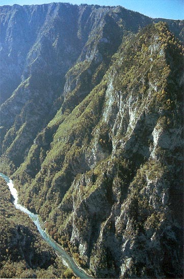
The Tara River cuts the Tara River Canyon, the longest canyon in Montenegro and Europe and second longest in the world after Grand Canyon, at 78 kilometers in length and 1,300 meters at its deepest. The canyon is protected as a UNESCO World Heritage Site. A part of the canyon includes the Durmitor National Park. The river takes its name from the Illyrian Autariatae tribe,[citation needed] whose territory included the river valley in classical antiquity.[citation needed]
Ecology
Ichthyofauna
The Tara river is rich in endemic salmonid fish species, huchen (Latin: Hucho hucho), otherwise globally endangered, and together with the river Drina and most of its tributaries, such as the Piva river before damming, the Bistrica, Ćehotina, Lim, Prača, Drinjača, Sutjeska, its still Europe's primer habitats and spawning grounds.
Tourism and recreation
Rafting is very popular on Tara River. It is also one of the most popular forms of recreation in Montenegro and Bosnia and Herzegovina. The one-day rafting route, from Brstnovica to Šćepan Polje is 18 km long and it takes 2 to 3 hours. Among the attractions of the area is Đurđevića Tara Bridge, on the crossroads between Mojkovac, Žabljak and Pljevlja.
Rafting starts at Splavista from where one starts the adventure 100 km long in the most beautiful and exciting part of canyon. Already at the beginning the Tara, the waterfalls of Ljutica are seen and then, the rafter passes under the 165-metre (541 ft) high Đurđevića Tara Bridge. The old Roman road can then be seen as rafters pass through the Lever Tara, "Funjički bukovi", and "Bijele ploče". "Nisovo vrelo" is the deepest part of the canyon at 1,100 metres (3,600 ft) high. Further is the bottom of the mountain top, "Curevac" (1650 m), that rises above Tara as its "eternal guardian". Rafting trips meet the waterfalls of Draga and then pass through the Radovan luka, the "Canyon of Sušica", "Tepački bukovi", "Brstanovički bukovi" and "Bailovica sige", ending at Sćepan Polje.

In 2005, the European Championships in Rafting were held on the Vrbas and the Tara rivers in Bosnia and Herzegovina. According to the International Rafting Federation, the event was hugely successful. In May 2009 the World Rafting Championships were held again in Bosnia and Herzegovina on the Vrbas and Tara rivers.[3]
Planned damming

The governments of Montenegro and Republika Srpska entity in Bosnia and Herzegovina had plans to flood the Tara river and considerable part of its gorge, with the construction of at least one and possibly more hydroelectric dams on the Drina and possibly the Tara itself. A plan to construct dams in Bosnia and Herzegovina on the Drina river, has never been shelved completely.[4][5][6] One at Buk Bijela village, some 15 kilometers downstream of border with Montenegro and the confluence of the Tara with the Piva river, the Buk Bijela Hydro Power Plant, although apparently abandoned in April 2005, after several successful protests by environmental activists in favor of preserving both the rivers and the canyon, is now being seriously reconsidered, as recently as 2018, and concessions were given to a company "HE Buk Bijela" created in Foča in 2018, for this purpose.[7] Also, although much older, signed in September 2006, a cooperation agreement between the Slovenian company Petrol and the Montenegrin company "Montenegro-bonus"[8] to plan a construction of a 40-60 megawatts hydroelectric power plant, despite all efforts to protect the gorge, is still a considerable environmental threat for the Drina and the Tara.
See also
References
- Statistical Yearbook of Montenegro 2017, Geography, Statistical Office of Montenegro
- "Sava River Basin Analysis Report" (PDF, 9.98 MB). International Sava River Basin Commission. September 2009. p. 14.
- WRC2009 in Bosnia and Herzegovina Archived 2009-10-06 at the Portuguese Web Archive
- Hydroelectric Power Plant BUK BIJELA
- Hydroelectric Power Plant FOČA
- Hydroelectric plants on Drina river
- "S zakašnjenjem od godinu dana osniva se "HE Buk Bijela"". capital.ba (in Serbian). 18 July 2018. Retrieved 8 September 2018.
- Power plant on the Tara
| Authority control: National libraries |
|---|
На других языках
[de] Tara (Drina)
Die Tara (serbisch-kyrillisch Тара) ist der Hauptquellfluss der Drina und übertrifft sowohl in der Wasserführung als auch mit 140 km Länge den anderen Quellfluss, die Piva (etwa 120 km). Somit ist die Tara der längste Fluss Montenegros. In ihrem Unterlauf hat sie eine spektakuläre Schlucht ausgebildet, die eine der längsten und tiefsten Europas ist.- [en] Tara (river)
[es] Río Tara (Montenegro)
El Tara (cirílico: Ријека Тара o Riyeka Tara) es un afluente de Montenegro que con el río Piva forman el afluente Drina, por lo que es un sub-afluente del Danubio, por el Save. El Tara recorre Montenegro y Bosnia y Herzegovina. Emerge de la confluencia de los ríos Opasnica y Veruša en los montes Prokletije, parte de los Alpes Dináricos de Montenegro. La longitud total es de 144 km, de los que 110 km están en Montenegro, mientras que los últimos 34 km están en Bosnia y Herzegovina; también forma la frontera entre los dos países en varios lugares. El Tara corre de sur a norte -noroeste y converge con el Piva en la frontera de Bosnia y Herzegovina y Montenegro entre los pueblos de Šćepan Polje (Montenegro) y Hum (Bosnia y Herzegovina) para formar el río Drina.[it] Tara (Montenegro)
Il fiume Tara (in serbo: Тара?) è un fiume che scorre in Montenegro e in Bosnia ed Erzegovina. Il fiume Tara non è da associare al monte Tara o al Parco nazionale di Tara, entrambi situati nell'ovest della Serbia.[ru] Тара (приток Дрины)
Та́ра (черног. Тара, босн. Tara) — река в Черногории и Боснии и Герцеговине. Образуется при слиянии рек Опасница и Веруша, течёт 144 км на север по территории Черногории, затем — Боснии и Герцеговины, где, сливаясь с рекой Пивой, образует реку Дрина. На реке в её верхнем течении стоит город Мойковац.Другой контент может иметь иную лицензию. Перед использованием материалов сайта WikiSort.org внимательно изучите правила лицензирования конкретных элементов наполнения сайта.
WikiSort.org - проект по пересортировке и дополнению контента Википедии