geo.wikisort.org - River
Regent's Canal is a canal across an area just north of central London, England. It provides a link from the Paddington Arm of the Grand Union Canal, 550 yards (500 m) north-west of Paddington Basin in the west, to the Limehouse Basin and the River Thames in east London. The canal is 8.6 miles (13.8 km) long.[1]
This article needs additional citations for verification. (October 2012) |
| Regent's Canal | |
|---|---|
 West portal of the Islington tunnel | |
| Specifications | |
| Length | 8.6 miles (13.8 km) |
| Maximum boat length | 78 ft 0 in (23.77 m) |
| Maximum boat beam | 14 ft 6 in (4.42 m) |
| Locks | 13 |
| Status | Open |
| Navigation authority | Canal and River Trust |
| History | |
| Principal engineer | James Morgan |
| Date of act | 1812 |
| Construction began | 14 October 1812 |
| Date of first use | 1816 |
| Date completed | 1 Aug 1820 |
| Geography | |
| Start point | Paddington Arm (Grand Union Canal) |
| End point | River Thames (Limehouse) |
| Branch(es) | Hertford Union Canal Limehouse Cut |
Regent's Canal | ||||||||||||||||||||||||||||||||||||||||||||||||||||||||||||||||||||||||||||||||||||||||||||||||||||||||||||||||||||||||||||||||||||||||||||||||||||||||||||||||||||||||||||||||||||||||||||||||||||||||||||||||||||||||||||||||||||||||||||||||||||||||||||||||||||||||||||||||||||||||||||||||||||||||||||||||||||||||||||||||||||||||||||||||||||||||||||||||||||||||||||||||||||||||||||||||||||||||||||||||||||||||||||||||||||
|---|---|---|---|---|---|---|---|---|---|---|---|---|---|---|---|---|---|---|---|---|---|---|---|---|---|---|---|---|---|---|---|---|---|---|---|---|---|---|---|---|---|---|---|---|---|---|---|---|---|---|---|---|---|---|---|---|---|---|---|---|---|---|---|---|---|---|---|---|---|---|---|---|---|---|---|---|---|---|---|---|---|---|---|---|---|---|---|---|---|---|---|---|---|---|---|---|---|---|---|---|---|---|---|---|---|---|---|---|---|---|---|---|---|---|---|---|---|---|---|---|---|---|---|---|---|---|---|---|---|---|---|---|---|---|---|---|---|---|---|---|---|---|---|---|---|---|---|---|---|---|---|---|---|---|---|---|---|---|---|---|---|---|---|---|---|---|---|---|---|---|---|---|---|---|---|---|---|---|---|---|---|---|---|---|---|---|---|---|---|---|---|---|---|---|---|---|---|---|---|---|---|---|---|---|---|---|---|---|---|---|---|---|---|---|---|---|---|---|---|---|---|---|---|---|---|---|---|---|---|---|---|---|---|---|---|---|---|---|---|---|---|---|---|---|---|---|---|---|---|---|---|---|---|---|---|---|---|---|---|---|---|---|---|---|---|---|---|---|---|---|---|---|---|---|---|---|---|---|---|---|---|---|---|---|---|---|---|---|---|---|---|---|---|---|---|---|---|---|---|---|---|---|---|---|---|---|---|---|---|---|---|---|---|---|---|---|---|---|---|---|---|---|---|---|---|---|---|---|---|---|---|---|---|---|---|---|---|---|---|---|---|---|---|---|---|---|---|---|---|---|---|---|---|---|---|---|---|---|---|---|---|---|---|---|---|---|---|---|---|---|---|---|---|---|---|---|---|---|---|---|---|---|---|---|---|---|---|---|---|---|---|---|---|---|---|---|---|---|---|---|---|---|---|---|---|---|---|---|---|---|---|---|---|---|---|---|---|---|---|---|
| ||||||||||||||||||||||||||||||||||||||||||||||||||||||||||||||||||||||||||||||||||||||||||||||||||||||||||||||||||||||||||||||||||||||||||||||||||||||||||||||||||||||||||||||||||||||||||||||||||||||||||||||||||||||||||||||||||||||||||||||||||||||||||||||||||||||||||||||||||||||||||||||||||||||||||||||||||||||||||||||||||||||||||||||||||||||||||||||||||||||||||||||||||||||||||||||||||||||||||||||||||||||||||||||||||||
History

First proposed by Thomas Homer in 1802 as a link from the Paddington arm of the then Grand Junction Canal (opened in 1801) with the River Thames at Limehouse, the Regent's Canal was built during the early 19th century after an Act of Parliament was passed in 1812. Noted architect and town planner John Nash was a director of the company; in 1811 he had produced a masterplan for George IV, then Prince Regent, to redevelop a large area of central north London – as a result, the Regent's Canal was included in the scheme, running for part of its distance along the northern edge of Regent's Park.

As with many Nash projects, the detailed design was passed to one of his assistants, in this case James Morgan, who was appointed chief engineer of the canal company. Work began on 14 October 1812. The first section from Paddington to Camden Town opened in 1816 and included a 251-metre (274 yd) long tunnel under Maida Hill east of an area now known as 'Little Venice', and a much shorter tunnel, just 48 metres (52 yd) long, under Lisson Grove. The Camden to Limehouse section, including the 886-metre (969 yd) long Islington Tunnel and the Regent's Canal Dock (used to transfer cargo from seafaring vessels to canal barges – today known as Limehouse Basin), opened four years later on 1 August 1820. Various intermediate basins were also constructed (e.g.: Cumberland Basin to the east of Regent's Park, Battlebridge Basin (close to King's Cross, London) and City Road Basin). Many other basins such as Wenlock Basin, Kingsland Basin, St. Pancras Stone and Coal Basin, and one in front of the Great Northern Railway's Granary were also built, and some of these survive.
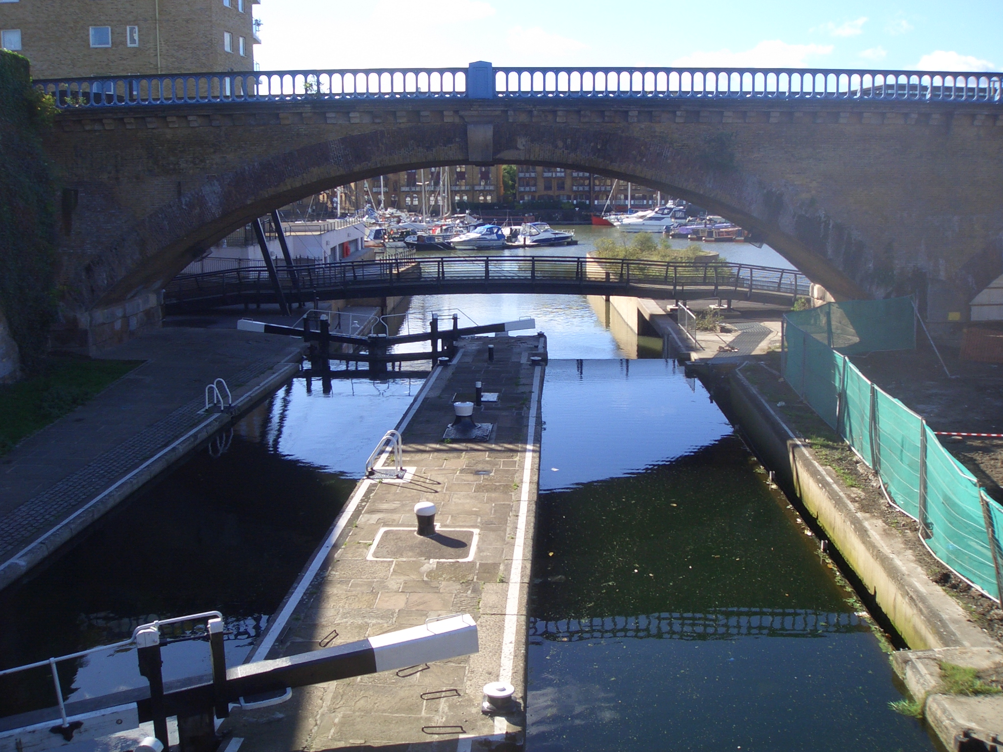
All the locks were built with duplicate chambers to facilitate the heavy barge traffic. With the demise of commercial traffic in the early 1970s, at the end of 1973, the British Waterways Board embarked on a three-year programme to convert one chamber at each lock into an overflow weir to facilitate unmanned use by pleasure craft without the risk of serious flooding due to incorrect use of the paddles.[2]
The City Road Basin, the nearest to the City of London, soon eclipsed the Paddington Basin in the amount of goods carried, principally coal and building materials. These were goods that were being shipped locally, in contrast to the canal's original purpose of transshipping imports to the Midlands. The opening of the London and Birmingham Railway in 1838 actually increased the tonnage of coal carried by the canal. By the early twentieth century, with the Midland trade lost to the railways, and more deliveries made by road, the canal had fallen into a long decline.[3]
Explosion of the barge Tilbury under the Macclesfield Bridge

Just before 5am on 2 October 1874 the narrowboat barge Tilbury which was loaded with sugar, nuts, three barrels of petroleum and around five tons of gunpowder exploded right under the Macclesfield Bridge, just outside London Zoo. Until the explosion, the Tilbury was part of a convoy consisting of a tugboat and three narrowboats travelling westwards heading for a quarry in the West Midlands.[4] [5]
Damage and aftermath
All the people on board died; captain Charles Baxton, a labourer named William Taylor, a third man and a young boy. The Macclesfield bridge was destroyed and rebuilt in 1876 reusing the cast iron pillars (made in Coalbrookdale according to an inscription at their top), but turning them by 180° (canal side towards tow path side) so tow rope grooves that were created before the incident can be seen on the outer side of the columns.
The explosion was heard 20 miles away. Debris flew in all directions, the roofs of surrounding houses blew off, windows smashed, trees uprooted and dead fish rained down on the West End. The tugboat's keel was found embedded in a house 300 yards away.[4] The bridge was nick-named the 'Blow-Up Bridge'.[5]
The damage would have been far worse had the barge exploded in the highly populated areas of Camden and Islington, which the convoy had passed through earlier that morning. The canal company that owned Tilbury was condemned for gross negligence in permitting the “highly imprudent and improper” practice of carrying petroleum and gunpowder aboard the same barge. The incident accelerated the passing of the Explosives Act in 1875,[6] which regulates the manufacture and carriage of dangerous substances.[4]
Railway projects
There were a number of abortive projects to convert the route of the canal into a railway. In September 1845 a special general assembly of the proprietors approved the sale of the canal at the price of one million pounds to a group of businessmen[7] who had formed the Regent's Canal Railway Company for the purpose.[8] The advertisement for the company explained:
The vast importance of this undertaking, whereby a junction will be effected between all existing and projected railways north of the Thames, combined with the advantage of a General City Terminus, is too obvious to require comment. By the proposed railway, passengers and goods will be brought into the heart of the City at a great saving of time and expense, and facilities will be afforded for the more expeditious transmission of the mails to most parts of the kingdom.[8]
The railway company subsequently failed, but in 1846 the directors of the canal went about trying to obtain an Act of Parliament to allow them to build a railway along its banks. The scheme was abandoned in the face of vigorous opposition, especially from the government who objected to the idea of a railway passing through Regent's Park. In 1859, two further schemes to convert the canal into a railway were proposed. One, from a company called the Central London Railway and Dock Company, was accepted by the directors, but once again the railway company failed. In 1860 the Regent's Canal Company proposed a railway track alongside the canal from Kings Cross to Limehouse, but funds could not be raised. Further schemes over the next twenty years also came to nothing,[citation needed] with the Metropolitan Railway that opened to the south in 1863 serving much the same purpose of linking the lines radiating north of London.
In 1883, after some years of negotiation, the canal was sold to a company called the Regent's Canal and City Docks Railway Company. at a cost of £1,170,585. The company altered its name to the North Metropolitan Railway and Canal Company in 1892, but no railway was ever built; instead it raised money for dock and canal improvement and eventually, in 1904, became the Regent's Canal and Dock Company.[7]
The Regent's Canal and Dock Company became part of the merged Grand Union Canal Company on 1 January 1929.

New uses
A new purpose was found for the canal route in 1979, when the Central Electricity Generating Board (CEGB) installed underground cables in a trough below the towpath between St John's Wood and City Road. These 400 kV cables now form part of the National Grid, supplying electrical power to London. Pumped canal water is circulated as a coolant for the high-voltage cables. The canal is frequently used today for pleasure cruising; a regular waterbus service operates between Maida Vale and Camden, running hourly during the summer months.[9]
Due to the increase in cycle commuting since the 2005 London Bombings[10] and increasing environmental awareness, the canal's towpath has become a busy cycle route for commuters. National Cycle Route 1 includes the stretch along the canal towpath from Limehouse Basin to Mile End. British Waterways has carried out several studies into the effects of sharing the towpath between cyclists and pedestrians, all of which have concluded that despite the limited width there were relatively few problems at the time of the audits.[11] More recently, in 2019, The Guardian reported on instances of conflict between pedestrians and cyclists.[12]
Geography
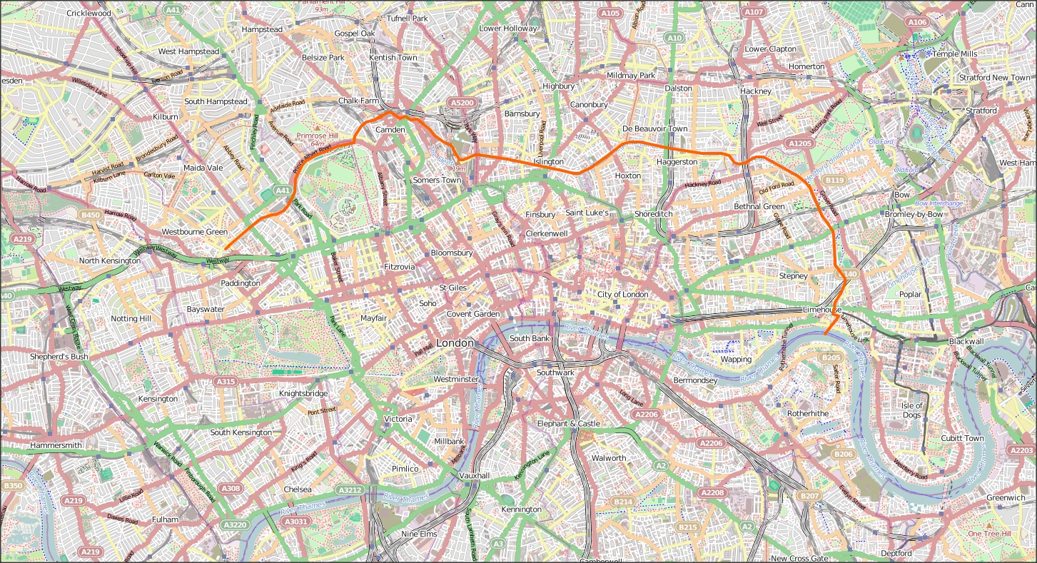
The Regent's Canal forms a junction with the old Grand Junction Canal at Little Venice, a short distance north of Paddington Basin. After passing through the Maida Hill and Lisson Grove tunnels, the canal curves round the northern edge of Regent's Park, passing London Zoo and skirting round the base of Primrose Hill. It continues through Camden Town and King's Cross Central. It performs a sharp bend at Camley Street Natural Park, following Goods Way where it flows behind both St Pancras railway station and King's Cross railway station. The canal opens out into Battlebridge Basin, originally known as Horsfall Basin, home of the London Canal Museum. Continuing eastwards beyond the Islington tunnel it forms the southern end of Broadway Market and meets the Hertford Union Canal at Victoria Park, East London. It turns south towards the Limehouse Basin, where it meets the Limehouse Cut, and ends as it joins the River Thames. [citation needed]
Maximum craft dimensions

On the Regent's Canal the maximum length is 21.95 metres (72.0 ft), with a beam of 4.27 metres (14.0 ft) and a headroom of 2.79 metres (9 ft 2 in). The navigational depth is, on average 1.15 m (3 ft 6 in).[13]
Culture
In 2012, playwright Rob Inglis was awarded a £16,000 Arts Council grant to write Regent's Canal, a Folk Opera, a musical that celebrates the 200th anniversary of the digging of the canal.[14] It played in a number of locations around London in 2012.[15]
See also
- St Pancras Cruising Club
- Camden Lock
- Kingsland Basin
- List of canal basins in Great Britain
- List of canal aqueducts in Great Britain
- List of canal locks in Great Britain
- List of canal tunnels in Great Britain
References
- "Regent's Canal".
- McKnight, Hugh (1978). The Shell Book of Inland Waterways. Newton Abbot: David and Charles.
- Islington: Communications, A History of the County of Middlesex: Volume 8: Islington and Stoke Newington parishes (1985), pp. 3–8 accessed: 22 July 2008
- "The Great Barge Explosion". Waterfront. 25 November 2015.
- "The Explosive History Of Blow-Up Bridge". Londonist. 26 January 2017.
- Explosives Act 1875
- Denney, Martin (1977). London's Waterways. London: B.T. Batsford. pp. 79–80. ISBN 0-7134-0558-9.
- "Regent's Canal Railway". The British and Foreign Railway Review. 1 (1): 306. 1845. Retrieved 5 July 2011.
- "Regents Canal Waterbus". London Waterbus Company. Retrieved 28 October 2017.
- 'Cycling on London's Waterways', British Waterways London
- See a presentation Archived June 8, 2011, at the Wayback Machine by British Waterways following a Safety Audit Archived July 8, 2011, at the Wayback Machine study by Transport Initiatives in 2006. Archived January 28, 2011, at the Wayback Machine
- Townsend, Mark (27 July 2019). "On roads, cyclists are vulnerable – but on towpaths they're the menace". Guardian. Retrieved 18 February 2021.
- Boating in London(British Waterways). Retrieved October 29, 2011 Archived May 5, 2011, at the UK Government Web Archive
- ""Regent's Canal" – a folk opera". Archived from the original on 22 December 2013. Retrieved 9 January 2014.
- Peter Gruner (23 August 2012). "Musical writer Rob Inglis finishes off folk opera script from hospital bed". CamdenNewJournal. Archived from the original on 9 January 2014. Retrieved 9 January 2014.
Further reading
- Alan Faulkner – The Regent's Canal: London's Hidden Waterway (2005) ISBN 1-870002-59-8
- Alan Faulkner – The George and the Mary: A Brief History of the Grand Union Canal carrying Company Ltd (1973)
External links
 Media related to Regent's Canal at Wikimedia Commons
- Canalplan AC Gazetteer: Grand Union Canal (Regent's Canal)
- Plan of Grand Union Canal (Regent's Canal) with links to places of interest near each lock, basin, and bridge.
- Photographs of Regent's Canal
- Regent's Canal interactive map
- More background information and history of the Regent's Arm
- Regent's Canal, Camden markets, history and pictures
- Regent's Canal Walk: Little Venice to Limehouse Basin (Walking Guide)
На других языках
[de] Regent’s Canal
Der Regent’s Canal ist ein 14 km langer Kanal im Norden von Londons Zentrum. Er verbindet den Paddington-Arm des Grand-Union-Kanals im Westen mit dem Limehouse Becken sowie der Themse im Osten von London.- [en] Regent's Canal
[it] Regent's Canal
Il Regent's Canal è un canale artificiale che attraversa la zona immediatamente a nord di Central London. Collega la sezione di Paddington del Grand Union Canal, a nord-ovest del bacino di Paddington, al Limehouse Basin e al fiume Tamigi nella zona est di Londra. Il canale è lungo 13,8 chilometri (8,6 miglia).[ru] Риджентс-канал
Ри́джентс-кана́л (англ. Regent's Canal, дословно «регентов канал») — судоходный канал в Лондоне, к северу от исторического центра и Темзы. Протяжённость — 13,8 км. Соединяет Гранд-Юнион-канал на западе (через Паддингтонский рукав) и Темзу на востоке (через район Лаймхаус). Проходит по северной окраине Риджентс-парка. По каналу курсируют традиционные английские канальные лодки — нэрроуботы компании «Лондонский водный автобус», приспособленные под экскурсионно-общественный транспорт[1][2].Другой контент может иметь иную лицензию. Перед использованием материалов сайта WikiSort.org внимательно изучите правила лицензирования конкретных элементов наполнения сайта.
WikiSort.org - проект по пересортировке и дополнению контента Википедии