geo.wikisort.org - River
The Limehouse Cut is a largely straight, broad canal in the East End of London which links the lower reaches of the Lee Navigation to the River Thames. Opening on 17 September 1770, and widened for two-way traffic by 1777, it is the oldest canal in the London area. Although short, it has a diverse social and industrial history. Formerly discharging directly into the Thames, since 1968 it has done so indirectly by a connection through Limehouse Basin.
| Limehouse Cut | |
|---|---|
 Looking North East along the Limehouse Cut | |
 | |
| Specifications | |
| Status | Open |
| Navigation authority | Canal and River Trust |
| History | |
| Original owner | Trustees of the Lee Navigation |
| Principal engineer |
|
| Other engineer(s) |
|
| Date of act | 1766 |
| Date of first use | 1769 |
| Geography | |
| Start point | Bow Locks |
| End point | Limehouse Basin |
| Connects to | (part of) Lee Navigation |
Limehouse Cut | |||||||||||||||||||||||||||||||||||||||||||||||||||||||||||||||||||||||||||||||||||||||||||||||||||||||||||||||||||||||||||||||||||||
|---|---|---|---|---|---|---|---|---|---|---|---|---|---|---|---|---|---|---|---|---|---|---|---|---|---|---|---|---|---|---|---|---|---|---|---|---|---|---|---|---|---|---|---|---|---|---|---|---|---|---|---|---|---|---|---|---|---|---|---|---|---|---|---|---|---|---|---|---|---|---|---|---|---|---|---|---|---|---|---|---|---|---|---|---|---|---|---|---|---|---|---|---|---|---|---|---|---|---|---|---|---|---|---|---|---|---|---|---|---|---|---|---|---|---|---|---|---|---|---|---|---|---|---|---|---|---|---|---|---|---|---|---|---|
| |||||||||||||||||||||||||||||||||||||||||||||||||||||||||||||||||||||||||||||||||||||||||||||||||||||||||||||||||||||||||||||||||||||
The Cut is about 1.4 miles (2.2 km) long.[1] It turns in a broad curve from Bow Locks, where the Lee Navigation meets Bow Creek; it then proceeds directly south-west through the London Borough of Tower Hamlets, finally making a short hook to connect to Limehouse Basin.
Origins
Before the Cut
![Elizabethan watermen towing barges near Enfield Lock. Detail from a large strip map[2] of the River Lea preserved at Hatfield House](http://upload.wikimedia.org/wikipedia/commons/thumb/6/6c/The_River_Lea_navigation_in_Elizabethan_times_%28map%29.png/390px-The_River_Lea_navigation_in_Elizabethan_times_%28map%29.png)
Already in Elizabethan times there was a vigorous river trade between towns on the River Lea and the City of London, but watermen had to await the tides and row round the Isle of Dogs. Thus in 1588 (wrote G. B. G. Bull):
A fleet of 44 barges, bearing such names as Maltsack, Ramshead, Greyhound, Pheasant, Primrose, Hind and Cock, with a total capacity of 1100 quarters were engaged in transporting wheat and malt from the Hertfordshire markets of Ware and Hoddesdon to Queenhythe in London. Barges were loaded at Ware on Saturday, reached Bow Lock on Monday,[3] and awaited the opening of the gates with the turn of the tide. Brisk rowing on the Thames brought the barges to London within four hours of clearing the Lea.[4] The return journey, with passengers or with a load of coal, pig-iron or salt, began on the ebb tide. When the tide changed, Bow Lock opened once more. From thence to Waltham took six hours, and to Ware six hours more.[2]
The goods came from even further afield: by 1663 the road from Huntingdon and Cambridge was worn out "by reason of the great Trade of Barley and Mault, that cometh to Ware, and so is conveyed by water to the City of London". In 1739, 25,000 tons of malt and "all sorts of Grain, Flower, and other Commodities" went by the Lee. When the Limehouse Cut was built this traffic had increased to 36,000 tons—about a quarter of London's grain supply.[5]
Planning and authorisation
The Limehouse Cut was authorised by the Lee Navigation Improvement Act 1766,[6][7] after the engineer John Smeaton identified the need to make several cuts and to replace existing flash locks on the river with pound locks.[8] It occurred to Smeaton[9] as an afterthought[10] to have a cut from Bromley to the Thames at Limehouse and his assistant Thomas Yeoman had the same idea. Thomas Yeoman was appointed as the surveyor to the River Lee trustees, and one of his first tasks was to investigate a route for the Limehouse Cut. As authorised by Parliament, it would provide a short-cut from the Lee Navigation at Bromley-by-Bow to the River Thames "at or near Limehouse Bridge Dock",[11] avoiding the tortuous curves of the lower reaches of the River Lea at Bow Creek, and the need to wait for the tide to make the long detour round the Isle of Dogs. The trustees accepted Yeoman's proposed route on 14 September 1767, which would terminate at Dingley's Wharf at Limehouse.
Excavation and lock building

The contract for the excavation of the cut was split into two, with Charles Dingley, owner of the wharf and also a trustee, getting the southern section up to Rose Lane and Jeremiah Ilsley getting the northern section to Bow Locks.[12] Dingley contracted to make his end of the canal for 10d. per foot; Ilsley's charge was 7d. per foot.[13]
The construction of Bromley Lock was let as a separate contract, which was awarded to a millwright from Bromley called Mr Cooper, who also built some of the locks on the Edmonton Cut. The lock into the Thames was designed by Mr Collard, another of the trustees, who produced a model and plan for the structure. The estimated cost was £1,547, but Collard had miscalculated the length, and it had to be increased by 16 feet (4.9 m), resulting in the estimate's rising to £1,696.
Inauguration and widening
By 1769, barges were using part of the cut, and in May 1770 an opening date of 2 July was set. However, 60 feet (18 m) of brickwork failed, and fell into the canal, delaying the opening until 17 September. There were further problems in December, when a bridge collapsed, blocking the canal, but once the teething problems were resolved, traffic increased steadily.
The cut was only wide enough for one barge, and in May 1772, a passing place was added, but by March 1773, the company had decided to widen the whole cut, so that barges could pass as any point. The contract for the work was given to Jeremiah Ilsley in June 1776, and the widened cut was operational from 1 September 1777, having cost £975.[14]
Further widening

At some stage the Cut was further widened from 55 feet to its present width of 75 feet. When this happened is unclear. It has been suggested it happened during the Beardmore modifications of the 1850s[15] (see below), but this seems improbable. Widening was not called for by Rendel's plans, nor is it mentioned by Beardmore himself. Possibly it happened during the construction of the Commercial Road. An 1809 print seems to show widening excavations alongside the Cut.
Hydraulics
Although the newly constructed Limehouse Cut could save vessels time navigating down Bow Creek and around the Isle of Dogs, its performance was suboptimal. Unusually, it was a tidal canal. It could be short of water and liable to shoal.
At the northern end of the Cut was a conflict with a property called Four Mills: in fact, a group of five tidal water wheels.[16] Nathaniel Beardmore, the Lee trustees' engineer, described the conflict as it was in early Victorian times:
The Four Mills Head has always formed part of the navigation of the River Lee, but as the water was the common property of so many [other] mills [as well], it became, systematically, a race, after each period of high water, which of them should draw the fastest, and practically, the result was always in favour of the Four Mills, which had five large wheels, with the greatest fall and the largest head-channel ... Under these circumstances, the interest of the proprietor of the Four Mills was entirely adverse to any regularity of navigation below Old Ford Lock; for in the Four Mills Head, unless barges could travel during about one hour of high water, they were constantly liable to take the ground when the water was lowered by the working of the mills; and, as the Limehouse Cut depended entirely on the tidal water, and was not navigable at neaps, there were frequently intervals of some days, during which there was no means of affording a passage to the Thames.[17]
At an 1850 inquiry by William Cubitt it was explained that because the Cut was unnavigable for four or five days at neap tides, barges had no way out to the Thames except via Bow Creek (which was toll free). Hence the tolls were lost.[18]
The Cut had no locks except at either end—despite the fall in the land, which was 17½ feet.[19] The shallowest point was therefore critical. "Limehouse Cut had always occasioned a great deal of trouble", added Beardmore, "on account of the water falling short, and of the slipping of the moving sands and gravel, which lay where the London clay was denuded".[20] No systematic attempt to improve the navigation was made until the Victorian era.
 Limehouse Cut c.1800, the only canal in London—called 'Poplar Cut' in this map
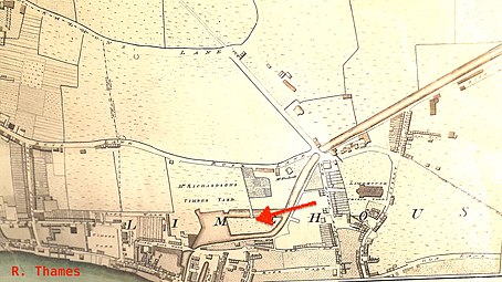 River Thames or Limehouse end, including the basin and its island (arrow)
 River Lee or Bromley end, showing junction with the Four Mills Head


The first Limehouse basin
Near its Limehouse end the Cut was widened to form a basin with an island in it. This was the first Limehouse basin, made 25 years before the better known Regent's Canal Dock. The reason for this is described below, see "The Island in the Cut and its mills".
Victorian modifications
Railway competition
By 1843 a railway had been built from Stratford to Hertford: it became the Eastern Counties Railway. The line ran[21] beside the River Lee[22] and threatened its carrying trade.
Closing the Four Mills
As an essential first step in 1847 the trustees of the Lee Navigation bought out the troublesome Four Mills and gradually stopped them using water power.[23]
James Rendel's scheme
In 1849 James Rendel was asked to devise a scheme to improve the infrastructure, which was dilapidated. He reported that "if [the Navigation] is to compete successfully with Railways, it should be made an efficient branch of the Thames, viz. navigable by the largest class of barges there employed".[24] He proposed, besides numerous improvements on the river proper, the reconstruction of Bromley Lock; deepening the Limehouse Cut; forming a towing path under Britannia Bridge (Commercial Road); and the construction of a new outfall lock into the Thames, with cills 19 feet below Trinity High Water, and with tide gates.[25]
Financing and politics


The engineering of the Limehouse Cut was affected by political disputes upstream. The Lee had multiple uses. It was a highway for traders. It supplied London with drinking water. It powered grain mills. It was a sewer for towns and factories. There was no Conservancy Board to manage these clashing interests, just the trustees responsible for its navigation.[26]
The navigation of the River Lee was governed by a board of 65–120 unpaid trustees, typically country magistrates. The most influential was James Gascoyne-Cecil, 2nd Marquess of Salisbury, who became chairman in 1851. A powerful nobleman[27] with a deep knowledge of parliamentary procedure, his biographer has described him as an eighteenth century aristocrat in a nineteenth century world.[28] Of the few trustees who used to turn up to meetings, only one was a trader who owned barges.[29]

Rendel's estimate for his scheme was £230,000[30]—about £30 million today[31]—yet the Trust's revenue was small.[32] However, John Marchant, clerk to the trustees, had hit on the idea of borrowing the capital and paying off the loans by selling more water to the London water companies.[33] This was essential to the scheme's success, Hertford's MP William Cowper told Parliament.[34]
The scheme was controversial.[35] It was opposed by many river traders who complained the benefits were not worth the money and the Trust would incur large debts: meaning higher tolls. Its promoters were certain it would pay for itself.[36] At an unusually large meeting of the Trust at Ware, the scheme was carried by 27–25 votes.[37] A Bill was put before Parliament to authorise it[38] and, despite opposition from radical politician John Bright—who suspected an ulterior motive[39]—became law on 1 August 1850.[40]
The pessimists proved correct. While the London water companies were interested in buying the water, and had said so, they had not tied themselves to a price; and soon showed who had the stronger bargaining power.[41] First, the New River [Water] Company struck a deal with the town of Hertford to get water from the pure and copious River Mimram—an upstream tributary, outside the Lee Trust's jurisdiction.[42] Then they and the East London Waterworks applied for Acts of Parliament of their own, by which they would get the River Lee's water.[43] There was litigation; the Trust ran into cashflow problems; and the eventual compromise was that the Companies got the whole of the River Lee's water—apart from that required for navigation—for comparatively small amounts.[44]
The upshot was that though there were valuable improvements, the Trust incurred a large debt without any obvious means to pay it off.[45] Though they had increased the tolls (sometimes steeply),[46] they ran out of funds. Sacrifices had to be made, and were made on the Limehouse Cut.
Beardmore's implementation

Rendel's plans were implemented by his former pupil Nathaniel Beardmore.[47] The first tranche of work was supposed to comprise the tidal portion (from the Thames to Old Ford), hence the Limehouse Cut. However funds ran out, work stopped in 1853,[48] and some of Rendel's plans had to be curtailed. When more funding became available in 1855 it had to be devoted to non-tidal parts of the Lee.[49]
Some changes were made before funds ran out, with the following effect. The governing level in Limehouse Cut was increased: the water was not allowed to fall 2 feet below Trinity High Water mark.[50] The Cut under the Commercial Road bridge was made wider and given a towpath. Larger barges could now be handled:[51]
| Barge Dimension (max) | With old Lee Navigation | With improved Lee Navigation |
|---|---|---|
| Draught | 4 feet | 6 feet |
| Length | 85 feet | 110 feet |
| Beam | 13 feet | 19 feet (via Regent's Canal outlet) |
These and other improvements were said to increase the tonnage on the Lee Navigation by 25% (but the tolls by 50%), despite competition from the Eastern Counties Railway.[52]
The Regent's Canal Company: the link to their basin


The outlet to the Thames, "an old timber lock of small dimensions", had become "more and more ruinous".[53] In October 1852 Beardmore reported that "The Limehouse Lock has bulged and the late Lock keepers house must be pulled down both to get at the repair required and because the house is in the act of Tumbling down".[54]
At about this time the Lee trustees, who were afterwards alleged to be too cosy[55] with the Regent's Canal Company, agreed to sell it the southern portion[56] of the Limehouse Cut. Since it was public trust property it could not be done without the sanction of Parliament, to whom a Bill was presented.[57] The nearby Regent's Canal Dock, already enlarged to a 9-acre basin, was crowded with shipping so the Company intended to enlarge it further, absorbing Limehouse Cut's lock and the remnants of its basin.[58]
While this matter was pending a link was dug (early 1854) to the Regent's Canal Dock, thus affording an alternative[59] outlet to the river.[60] Work south of the Commercial road was supervised jointly by Beardmore and the Regent Canal's engineer.
The new route to the Thames could get congested[61] and the proposal was not popular with the Lee and Stort bargemen.
The river Lee was a public highway for all the Queen's subjects to go upon with their goods and Barges when and where they pleased ... as much a public highway as Ratcliffe Highway or Cheapside
said a Harlow bargeman. They disliked the prospect of being under Regent's Canal regulations. They organised meetings,[62] learnt to use the democratic machinery of the day,[63] and defeated the proposal in Parliament[64] reputedly at small cost to themselves.[65] The Regent's Canal Company had to be content with a more modest dock enlargement[58] and in May 1864 the link was filled in.[66]
Beardmore replaced the old timber Limehouse Lock with an "economical structure"[58] which was wider and had arched sheets overhead to stop bulging, after the Dutch fashion.[54]
Britannia Bridge and Lock

Britannia Bridge is where the Commercial Road crosses the Cut. It was named after the Britannia Tavern (c.1770-1911), which can be found in Horwood's 1819 map[67] and is visible in the image Limehouse in 1809 (above, "Further widening"), left background. The original bridge cramped the Cut and interrupted its towpath.[68]
When the Limehouse Cut was connected to the Regent's Canal Dock (above), a potential hydraulic problem was created. Since the Limehouse Cut was tidal, but the Regent's Canal was not, at times water might escape from the Dock and move up the Cut. (Conversely, at other times water from the Cut might overfill the Dock.) To restrict the loss of water a new lock was built at Britannia Bridge. It was a double regulating lock, with gates pointing in both directions, and new wing walls so as to form, conjointly, a new and more spacious Bridge. Horses could pass along the new towpath underneath. The work was supervised jointly by Beardmore and the Regent Canal's engineer.[60]
The lock gates were little used ("they never were, nor could be, used to keep out the tidal water, which comes into the Cut through many channels", wrote engineer Joe Child), and they were removed.[66]
The new Bromley Lock
Bromley Lock was completely rebuilt in a slightly different[66] position. Said Beardmore:
The old Bromley Entrance Lock of the Limehouse Cut, and the other works, were much dilapidated, and the 300 yards of the Cut, adjacent to the lock, having been originally made in rather heavy cutting, through London clay capped by running sands and gravel, had frequently slipped, and had been protected, from time to time, by piles; these again had slipped and formed such serious impediments to the passage of the barges, that at every neap tide, the Cut was practically useless for several days. The works have, therefore, embraced the re-construction of Bromley Lock Entrance to the Limehouse Cut, and the deepening, widening, walling, and cutting down the slopes, on the portion above described.[69]
The new lock was 137 feet long and 22 feet broad, with cills 11 feet below Trinity high water mark.[47] In 1888 Joe Child (one of Beardmore's successors) wrote:
The pointings and chambers of these locks were so filled up with mud, rubbish, old pans and kettles thrown in that when the gates were closed for the purpose of drawing the water at Limehouse or Bow the leakage was so great that we could not keep a head of water in the Cut so that before again drawing it was necessary to clear out the locks which has been done but the gates at Bromley still leak very much ..and will require a short stoppage for repair.[66]
Bromley Lock was finally removed; according to Lee historian Richard Thomas, one gate can still be seen, behind the floating towpath.[66]
Twentieth century modifications
Bow Locks were originally semi-tidal, as high spring tides flowed over the top of the locks, altering the level in the Limehouse Cut and the southern section of the Lee Navigation. They were modified in 2000, when a flood wall and an extra pair of flood gates were installed, enabling the lock to be used at all states of the tide and stabilising the level of the cut.[70] Funding for the project was provided by the London Waterway Partnership.[71]
Following the takeover of the canal by British Waterways in 1948, a vertical guillotine gate was fitted on the north side of Britannia Bridge but this was removed in the 1990s.[72]
By the 1960s, the lock that connected the cut to the Thames was in need of replacement. It had been rebuilt in 1865, after the closing of the link to the Regents Canal Dock, and the design had included massive timber ties over the top of it to prevent bulging of the walls. These were eventually replaced with a steel cage, which served the same purpose.[73] Access to the lock from the cut and from the Thames was awkward, and the gates were operated by winches and chains as the site was too narrow to accommodate balance beams. At the time, there was significant commercial activity on the cut, which would have been severely disrupted by the construction of a new lock. The solution adopted was to reinstate a link to the Regents Canal Dock. The route used in the 1860s could not be reused, as it was now covered by buildings, and so a new length of canal, only about 200 feet (61 m) long, was built. The new link was opened on 1 April 1968, when the tug Miriam towed four lighters through it. The old lock was then filled in but one of the winches was saved and was put on display at Hampstead Lock.[74]
Social and industrial history
The Island in the Cut and its mills
John Cary's New and Accurate Plan of London of 1795 shows that, by that date, a portion of the canal, near its outlet at Limehouse, had been expanded to form a large basin, with an island in the middle marked "Timber Yd", accessible by a causeway.[75] This was the first basin in Limehouse, built 25 years before the better known Regent's Canal dock which now bears that name.
Charles Dingley's sawmill
![The Island, Limehouse Cut in 1819 (red arrow) and (left) the newly built Limehouse Basin of the Regent's Canal[76]](http://upload.wikimedia.org/wikipedia/commons/thumb/c/c3/The_Island%2C_Limehouse_Cut.png/220px-The_Island%2C_Limehouse_Cut.png)

In Richard Horwood's 1819 map[77] (extract reproduced here) the basin with Island are drawn to scale; nearby rows of houses are named 'Island Row' and 'Mill Place', respectively. Those streets still exist in Limehouse but the "Island" and the "Mill" themselves are largely forgotten. They originated as follows.
Charles Dingley was an entrepreneur and speculator who built, amongst many other things,[78] the southern end of the Limehouse Cut. At that time wooden planks were expensive because they were sawn by hand, or imported ready sawn;[79] in England[80] there was hostility to sawmills,[81] which were thought to be illegal.[82] Dingley, who was also a major timber merchant, decided to defy convention by building a wind-powered sawmill. He bought up a "stranglehold" of land in Limehouse and built the sawmill strategically[83] close to the line of the intended Cut,[84] which he may have promoted with that very intention. It was the only sawmill in England and did good business.
However, on 10 May 1768—the day of the St George's Fields Massacre riots—a mob of 500 men, including hand-sawyers, attacked his sawmill and destroyed the machinery—anticipating the Luddite machine-smashers of later years.[85] It caused Parliament to pass an Act making it a felony to vandalise mills.[86] Dingley repaired his mill by 1769.[87] Surviving records are consistent with the island and basin being constructed to isolate and protect the repaired sawmill.[88]
The Island Lead Mills


The sawmill fell into disuse before 1806,[87][89] but by 1817[90] a lead mill was built on the island, called The Island Lead Mills. It continued a thriving business into the twentieth century—it had one of the first telephones in the East End of London[91]—and its barges used the Cut; the company ceased to exist only in 1982.[92]
By about 1868, however, the expanding Regent's Canal Dock had encroached so that the Island was no longer strictly such, and further portions were filled in later in the nineteenth century.[93] Even so, traces can still be discerned adjacent Victory Place, Limehouse, which is built on the site.
Boatbuilding alongside Limehouse Cut

At Limehouse, across the Cut from the Island, was the boatyard of T & W Forrestt, builders to the Royal National Lifeboat Institution.[94][95][96] The firm built the Institution's self-righting lifeboat,[97] which they publicised by testing in the waters of the adjoining Cut.[98][99] Reportedly these boats saved upwards of 12,000 lives.[100] Other notable builds included the Admiralty's fast anti-torpedo boats powered by the noiseless Willans engine,[101] and the yawl Rob Roy (one of the first vessels used in solo adventuring).[102][103] When it became urgent to send an expedition to the Sudan to rescue General Gordon the firm built and delivered, in less than a month, 100 boats to a special design for ascending the cataracts of the Nile.[104]
Forrestt's yard was called Norway Yard, a name that survives in Norway Place. The image—an engraving in the Illustrated London News—shows the boatyard after its restoration from a disastrous 1858 fire. In the foreground is the London and Blackwall Railway with (in the distance) Stepney Station, now Limehouse DLR. The railway arches traverse Mill Place and Island Row. The Cut is visible at left centre. Across the Cut is the Island, with the Island Lead Mills (smoking chimney). The rigging in the background reveals shipping lying in the Thames (left) or in the Regent's Canal Dock (centre).
Stinkhouse Bridge
Bow Common Lane met the Cut at Stinkhouse Bridge, so called even in official documents. The name first appears in an 1819 map[105] and in an 1826 magistrates' report listing the bridges of Middlesex.[106]
It was a desolate area originally, recalled a local historian, so chemical manufacturers went there for the opportunity to pollute. Hence the stench and the name.[107] A subsidiary cause was filth from the notorious Black Ditch—a medieval sewer, originating in Spitalfields and discharging its waste in Limekiln Dock.[108] At this place an open ditch, it had been fed under the Cut by a syphon, but it overflowed in stormy weather. More than once Stinkhouse Bridge required the attention of Joseph Bazalgette himself.[109] "The smell is so bad that sometimes we cannot sleep in our beds", complained an 1856 petition. The main cause of the stink, thought Bazalgette, was factories discharging effluent into the Cut.[110]

As time went by Stinkhouse Bridge became the nucleus of "the largest chemical and inflammable factories in London": the district was a fire risk. In 1866 it caught fire at last. So tremendous was the blaze that, reportedly, every unit in the London Fire Brigade knew to turn out—and where to go—just by "the great light in the sky". Many people jumped into the Cut to avoid being burned to death.[111]
About 200 yards up the Cut[112] was the RNLI's storeyard.[113] Lifeboats were kept there prior to release to service. Before that, they were sunk in the waters of the Cut to test their self-righting powers, as shown. The tests also required men to stand on a gunwale until it was submerged.[114] Across the Cut began the notorious Fenian Barracks slum area, see below.
There are many reports of individuals trying to end their lives by jumping off Stinkhouse Bridge. In 1909 Coroner Wynne Baxter remarked that he had held inquests on over 50 suicides there. In a derisory attempt to enhance its image it was renamed Lavender Bridge.[115] So dirty was the water that when a local labourer dived in to save a woman trying to drown herself, the magistrate awarded him special compensation from the poor box.[116]
The bridge was rebuilt in 1929.[117] It continued to be a well known East End placename even after the stink had gone. In Call the Midwife: A True Story of the East End in the 1950s the runaway Irish girl Mary lingers at Stinkhouse Bridge. "It was pleasant standing by the bridge, looking down at the moving water."[118]
Bathing
In 1833 the Limehouse Cut was the place most frequented for bathing, an East London magistrate told Parliament. The authorities tried to ban the practice for indecency.[119]
Pollution. The cholera and smallpox controversies.
The Cut becomes an open sewer

Until about 1815 it was illegal to discharge human waste except into cesspools; "sewers" originally were for rainwater. Then the practice gradually changed and in 1846 it became compulsory to drain houses into sewers.[120] Sewers had always discharged into the Thames, and so Limehouse Cut itself became another sewer — in the modern sense — and, when population and industries crowded around its banks, a "very filthy" one.[121]
William Farr wrote that in 1849 some houses near the Lea had no drinking-water supply, so the poor were forced to dip their pails in the Limehouse Cut. Apart from the chemical waste, he said, "the canal is a receptacle for dead dogs, cats, and other small animals, frequently seen floating on the discoloured waters; and on every occasion of opening the locks at Bromley there is a rush of floating scum into the Lea'. Amongst those who drank the water, deaths by cholera were observed.[122]
As population increased the Lee itself became polluted with sewage, as did the Thames: the sewage was brought in by the tides and locked in the Cut, where it accumulated.[123] In 1866 the Lee Navigation's engineer agreed that in hot dry weather the Cut was "An open continuous cesspit ... As foul as it could be.".[124] In 1877 it was complained the layer of sediment was several feet thick.[125]

Cholera epidemic
In 1866 there was a major cholera epidemic in East London. Conventional medicine (the miasma theory) blamed polluted air, so there was an outcry against the Limehouse Cut. However, The Lancet appointed a sanitary commission who plotted the cases on a large map and discovered that living near (or far from) the canal had nothing to do with the risk of dying of the disease. They were led to reject the miasma explanation and to suspect the drinking-water.[126] It was afterwards proved that faecally contaminated water had got into the East London Waterworks Company's supply and been pumped to households — a step in medical science towards rejecting the miasma theory and establishing the currently accepted germ theory of disease.
But Thomas Orton, the Limehouse medical officer of health, was not a convert. In his district, he said, "water-drinkers" (teetotallers) scarcely ever got the cholera: it must be the bad air from the canals.[127]
The smallpox hospital

In 1876 there was a smallpox outbreak in London and the authorities struggled to find suitable hospital accommodation. Some patients were placed in a hospital in Hampstead but this attracted the ire of local residents; one of them, Sir Rowland Hill, sued. The authorities then rented the disused Silver factory - sandwiched between the Limehouse Cut and Dod Street - and made plans to convert it into a hospital. It infuriated East Enders that West End bureaucrats should send smallpox patients to a crowded working district in Limehouse ("Another opportunity for the West to look down on and revile the denizens of the East" sneered the East London Observer) and there were demonstrations in Trafalgar Square and threats of violence.[128]
Samuel Charlesworth, Rector of St Anne's Limehouse, wrote that it was a very bad place for patients anyway. Highly insalubrious, it had no ventilation "to move the fog often settling there, except the current of offensive vapour moving up and down the fœtid canal." He, the Rev. Charleswoth, knew the Cut was unhealthy because he lived next to it himself;[129] his children "when at home always fail in health". Opposite, six children of one family had died in one month — of some blood infection. Their coffins had been superposed in the same grave.[125]
Cleanup
But the cleanup of Limehouse Cut was already underway. It worked for two reasons: Bazalgette's strategic system of intercepting sewers; and an Act of Parliament[130] which gave the Lee Conservancy Board powers to pursue polluters — for this purpose the Limehouse Cut was deemed to be part of the Lee — and to dredge sewage.[131] In the Cut, already by 1877 the Board had closed down 36 private sewers.[121] By the end of the century its dredgers were removing 40 tons of sediment a day.[132]
The Burdett Road Bridge enclave

In 1819 the Cut ran through open countryside from Bromley lock to Britannia Bridge, Commercial Road. There was no way of crossing this except at Stinkhouse Bridge. To the northwest, see map, was the Patent Cable Works, a long ropewalk founded by Captain Joseph Huddart where was made his twice-as-strong ship's cable.[133] In due course the area was built up, the Cable Works closed and in 1858 its line was used to construct the "Victoria Park Approach Road" — soon renamed Burdett Road after philanthropist Angela Burdett-Coutts. A new bridge had to be made over the Cut. For the sake of the barge traffic Parliament required the bridge to allow headroom of at least "Eight Feet above High Water Mark, Trinity Standard".[134]
Dod Street and socialism
Dod Street, on the corner by Burdett Road Bridge and whose factories overlooked the Cut, was built and named by 1861.[135] It first attracted public attention in the smallpox hospital controversy (above) and then as a site for Sunday political meetings. Socialists like John Burns,[136] Amie Hicks,[137] Henry Hyndman[138] Eleanor Marx,[139] William Morris[140] and George Bernard Shaw,[141] among others, were speakers there.
The Dod Street trick

Dod Street gave rise to the expression "the Dod Street trick" used in socialist politics. The police felt these meetings were subversive and sought to prevent them by arresting demonstrators for highway obstruction. Since there was no traffic to obstruct — it was a street of canal-side factories on a Sunday — the police were perceived as denying freedom of speech.

The Dod Street trick, devised to counter this, was thus described by Bernard Shaw:[142]
Find a dozen... who are willing to get arrested at the rate of one a week by speaking in defiance of the police. In a month or two, the repeated arrests, the crowds which they attract, the scenes which they provoke, the sentences passed by the magistrates... and the consequent newspaper descriptions, rouse sufficient public feeling to force the Home Secretary to give way whenever the police are clearly in the wrong,
which is what happened. Public indignation gathered enormous crowds of people — only a very few of which were socialists[143] — and they were let alone.[144]
The image captioned The law blacks William Morris' boots[145] is a political caricature mocking class justice and Morris' genteel socialism. At a trial in Arbour Square magistrates court, plebeian demonstrators had been found guilty and punished, but Morris was only dismissed with a warning. It symbolically has the law blacking Morris' boots in Dod Street — his foot rests on comrades who did get jail time or "smarting" fines — while on his banner is an ironical reference to his high-flown poem The Earthly Paradise.[146]
Detail image
![Dod Street sketched on Sunday 27 September 1885[147]](http://upload.wikimedia.org/wikipedia/commons/thumb/2/20/Dod_Street%2C_Limehouse_%281885%29.png/390px-Dod_Street%2C_Limehouse_%281885%29.png)
The cartoon captioned Dod Street Demonstrations[148] contains an inset which, though incidentally, illustrates the area in late Victorian times. The detail is reproduced here. The arrow points towards Limehouse Cut.
In the left foreground 1 is the rubber factory of Abbott, Anderson & Abbott who made the capes for the Metropolitan Police[149] and oilskins for the Royal Navy.[150]
The last building 2 on the left — the one with the double lamps — is the "Silver Tavern" public house,[151] informal headquarters of the East End Football Association,[152] in which played such teams as Millwall Rovers, Tottenham Hotspur[153] and the East End mission of Eton College.[154]
In the distance 3 is St Anne's Limehouse, while at the bottom of the street can be seen the Burdett Road horse-drawn tramway — a tram 4 has just crossed the Bridge. Across Burdett Road begins the notorious St Anne Street Rookery, described below.
The last building on the right 5 is a warehouse soon to become the Outcasts' Haven (below).
Cutting edge industry

Taking up most of the north side of Dod Street and backing onto the Limehouse Cut was the highly innovative H. Herrmann factory. Opened in 1877 by American Henry Herrmann, it made hardwood furniture and was the first in England to do so almost entirely by machine.[155] Its stock of timber — easily imported by water — was described in the East London Observer as "something enormous", yet swiftly turned into good furniture "at the lowest possible prices".[156] Handled by a steam crane — risky in timber yards — the whole factory burned down in a colossal fire in 1887. (The fire got dangerously close to the East London Saltpetre Works, until extinguished by the Fire Brigade's floating engines on the Cut).[157] Herrmann rebuilt the factory and introduced one of the world's first electric travelling cranes to save on the steep insurance premiums. As there was no electrical supply in London, he generated his own, and had the factory electrically lit.[158]
At Herrmann's in 1884, while planning his London bombing campaign, worked Irish-American dynamitard Harry Burton;[159] he lodged round the corner in Pelling Street.[160]
The Fire Brigade continued to use floating fire engines on the Cut ("fire boats") until at least 1929.[161]
The Outcasts' Haven

In a disused warehouse at 1A Dod Street, opposite the Silver Tavern, was the Outcasts' Haven. According to Charles Dickens Jr., the first rule of the establishment was this:
Any outcast boy or girl, up to the age of sixteen, without parents, guardians or friends, and who has no home but the streets, will be admitted at once, at any hour of the day or the night free, and be provided with a bath, warm clothes, food and a bed.
Any policeman on the beat "who finds some poor outcast shrinking from the flash of his lantern", wrote Dickens, knew to send the child to Dod Street.[162]
But, according to an exposé in the investigative journal Truth, it was part of a charity scam. Run by a man called Walter Austin and his mistress Frances Napton ("the Lady Superintendent"), the charity put on stunts (see illustration), sent out heart-rending appeals, collected large donations, but kept no proper accounts. While it did spend some money on homeless children, its proprietor lived well.[163]

Victorian recycling
East End refuse collectors — called "dustmen", because households produced much coal ash — took the product to two yards[164] on the Limehouse Cut, where it was hand-sorted into separate hills by gangs of old men, women and boys. The ash and breeze was sent by barge to Kent, where it was made into bricks; the rags, bones and metal were sold to "marine-store dealers";[165] the old tin was sold to trunk-makers; the old bricks and oyster shells were sold to builders and road-makers; the old boots were sold to Prussian blue manufacturers; the money and jewellery were kept.[166]
The Copenhagen Wharf recycling facility can just be discerned in the 1886 photograph (left background). The scene is a few yards west of Burdett Road bridge. In the centre is Hirsch's Copenhagen Oil Mills, where seeds were crushed to make oil. Dumb barges are moored in the foreground. To the right is the Victoria Lead Works.
Rookeries
A rookery was a slum area whose inhabitants aggressively and cooperatively opposed law enforcement.
St Anne's Street Rookery

Across Burdett Road was St Anne's Rookery, "a vile quarter lying between Limehouse Church and Limehouse-cut".[167] Marked black on Charles Booth's poverty maps — the colour coding denoted "Lowest class. Vicious, semi-criminal" — it was one of the few slums alongside the Cut; usually, the land was too valuable for housing.[168]
This notorious enclave, into which a policeman might be dragged by a mob,[169] continually featured in newspaper reports. It included St Anne Street, where a man starved his wife in "peculiarly horrible" circumstances (1872);[170] and Merchant's Row, where a labourer kicked his mother to death (1897).[171] Law enforcement could be dangerous.[172]
The Fenian Barracks
![The Fenian Barracks (black): the most dangerous rookery in London. The fat refinery (arrow) attracted the even more terrifying canalside rat hordes.[173]](http://upload.wikimedia.org/wikipedia/commons/thumb/d/d0/The_Fenian_Barracks.png/220px-The_Fenian_Barracks.png)
Even more dangerous to police was the district near Stinkhouse Bridge bounded by Limehouse Cut to the south and centred on Furze Street.[174] Charles Booth's police informants called it the Fenian Barracks, which "sent more police to hospital than any other block in London and in which only Irish were tolerated to settle".[175]
George H. Duckworth, one of Booth's researchers,[176] wrote that the Barracks was about the worst district in London — "three policemen wounded there last week". According to his informant Inspector Carter, if they attempted an arrest "a rescue is always organized. They fling brick bats, iron, any thing they can lay their hands on."[177] As was typical for rookeries, adjoining houses had internal passages designed for eluding police pursuit. Summarised Duckworth:
Men travel from house to house from within if chased. A cry of police brings help from every house. The inhabitants hustle the police, they organize rescues; not the least bit of good [using] anything less than 6 constables ... if there is any prospect of having to haul off anyone to the police station.[178]
In contrast, rent collectors went about the district in broad daylight wearing top hats and black coats and carrying umbrellas.[179] A fat refinery alongside the canal[180] attracted visitors who, said Inspector Carter, were more terrifying than the human inhabitants:
You should come down here on an early summer morning; if possible after a shower of rain; Rats, not in twos or threes or in 10s or twentys, but in thousands and tens of thousands: the street will be covered with them, so will be the yard of the factory: rats, not small rats but big & fat, the size of cats : you knock a flagstone with your boot and away they go with a rush and a hissing sound from their feet upon the pavements that will make your blood run cold.[181]
The East End was surveyed again in 1929 by researchers from the London School of Economics who found that, though the level of destitution in East London was now only about one-third as high as in Charles Booth's time, the Fenian Barracks area was still an ugly pocket of chronic poverty.[182]
Caird & Rayner


At 777 Commercial Road, opposite Limehouse Church, and backing onto the Limehouse Cut, stands a derelict building bearing the faded sign V.I.P. Garage. Originally (1869) a ships chandler's, with the best surviving example of a sail loft in Docklands, it was then extended to the east and formed the workshop and offices of Caird & Rayner. This firm specialised in desalination apparatus, crucial for maintaining ship's boilers — and drinking water — on long sea voyages. Patented in 1888, their apparatus was fitted on dreadnoughts, British and Japanese battleships, Cunard liners, and "the Czar's new yacht". A specimen is in the Science Museum. Water from the Cut was used for testing the equipment. The firm moved in 1972.
In 2000 the building was listed, both for its historical and architectural interest. The engineering workshop is a very early example of fully steel structural framework, probably the only surviving one in London.[183]
National politics
On 25 January 1981 the Gang of Four stood on the bridge over former Limehouse Lock and issued the Limehouse Declaration.
Other names
Limehouse Cut has been known by other or alternative names:
| NAME(S) | SOURCE | DATE |
|---|---|---|
| "River Lea" (even where entering Thames at Limehouse) | John Cary's New and Accurate Plan of London and Westminster[184] | 1795 |
| "Limehouse Cut or Bromley Canal" | John Fairburn's Map of London and Westminster[185] | 1802 |
| "Poplar Cut" (not to be confused with Poplar Gut) | Edward Mogg's London in Miniature[186] | 1809 |
| "Lea Cut" (in Bromley); "Limehouse Cut" (in Limehouse) | G. F. Cruchley's New Plan of London[187] | 1827 |
| "Bromley Canal or Lea Cut" | Kelly's Post Office Directory Map[188] | 1857 |
| "Lea Cut" (east of Bow Common Lane); "Limehouse Cut" (to west) | Cross's New Plan of London[189] | 1861 |
Today


Most use of the canal is for pleasure, both on the water and beside the water on the towpaths. Regent's Canal, the Hertford Union Canal, the Lee Navigation and the Limehouse Cut form a four-sided loop, covering a distance of 5.5 miles (8.9 km), which can be walked or cycled.[190] The scenic towpaths cut across roads and railways in the area, providing a distinct viewpoint.
Access on foot along the Limehouse Cut was difficult in the area below the Blackwall Tunnel approach road, but was made easier as a result of an innovative scheme to create a floating towpath. This was opened in July 2003 and consisted of 60 floating pontoons, creating a 240-metre (262 yd) walkway complete with green glowing edges.[191]
The Cut is part of the Lee Navigation and is administered by the Canal & River Trust. It was built for sailing barges, and can accommodate vessels which are 88 by 19 feet (26.8 by 5.8 m). Headroom is limited to 6.75 feet (2.06 m).[192] The lock from Limehouse Basin to the Thames was originally a ship lock, but has been replaced with a smaller one. Although the area around Limehouse Basin and the original lock into the Thames have been extensively developed as part of the Docklands Regeneration scheme, the row of houses overlooking the lock, which were built in 1883 by the Lee Conservators, have been retained and refurbished, while the site of the lock is now a shallow pool.[73] At the end of the London 2012 torch relay, David Beckham arrived with the Olympic torch on a speedboat via the Limehouse Cut to the Olympic opening ceremony.
Points of interest
| Point | Coordinates (Links to map resources) |
OS Grid Ref | Notes |
|---|---|---|---|
| Bow Locks | 51.5233°N 0.0081°W | TQ382823 | northern end of cut |
| A12 Blackwall Tunnel Approach | 51.5216°N 0.0104°W | TQ381821 | Floating towpath under bridge |
| Docklands Light Railway bridge | 51.5192°N 0.0154°W | TQ377818 | |
| A13 road bridge | 51.5124°N 0.0318°W | TQ366811 | |
| Limehouse Basin | 51.5111°N 0.0362°W | TQ363809 | southern end of cut |
See also
- Spratt's Complex, an adjacent warehouse conversion including a large building called Limehouse Cut
- Canals of the United Kingdom
- History of the British canal system
References
- Edwards 1972, p. 134
- Bull 1958, p. 377
- If conditions were favourable. In extremely dry weather barges might be held back a fortnight: Fairclough 1989, p. IV
- Assuming favourable tides and winds. They were unreliable, so that some traders preferred to transship at Hackney or Stratford and continue by road: Fairclough 1986, p. 283.
- Fairclough 1989, p. III
- Lee Navigation Improvement Act 1766.
- The official short title of Acts of Parliament relating to the navigation of this river is "The Lee Navigation Improvement Act" followed by the year of its enactment: Lee Navigation Improvement Act 1850 s.90.
- Smeaton 1837, pp. 374–7
- Already in 1573 a Dutch engineer had proposed and drawn a canal between the Lea and Limehouse: Fairclough 1986, pp. 31–35.
- Wrote Smeaton: "On inspection of the plan, it seems very desirable that a cut should be carried from the four mill pond at Bromley to the Thames at Limehouse hole, and which, from a general knowledge of the ground, I believe very practicable; yet, as this thought did not occur to me till I was compiling the plan, I must refer the gentlemen to Mr. YEOMAN's Report thereupon, to whom the same thought has occurred, and who has viewed and levelled the same, and which I shall inspect when I go up to town, if thought eligible.": Smeaton 1837, p. 376
- Lee Navigation Improvement Act 1766, p. 705
- Boyes & Russell 1977, pp. 20–21
- Appleby 1995, pp. 184–5
- Boyes & Russell 1977, pp. 21–22
- London Borough of Tower Hamlets 2011, p. 7
- The Four Mills were about half a mile downstream the still-surviving Three Mills: Beardmore 1854, p. 450 (Plate I}
- Beardmore 1854, pp. 242–3
- Hertford Mercury 1850a, p. 5
- Priestly 1831, p. 411; Bradshaw 1832, p. 6
- Beardmore 1854, p. 250
- And runs.
- Field 1866, p. 20
- Beardmore 1854, p. 243
- Rendel 1850, p. 5
- Rendel 1850, p. 15
- Rivers Pollution Commissioners 1867, pp. vii–xxiv. The 1864 cholera epidemic in East London prompted a Royal Commission to examine the pollution of the River Lee and take evidence: Their report led to the Lee Conservancy Act, 1868.
- "In every important sphere of activity in Hertfordshire and in neighbouring counties he accrued titles and powers which he was shameless in using to promote and enforce his will; though this was always within the letter and upholding of the law": Webster 2016, p. 68
- Webster 2016, pp. 52–55
- Rivers Pollution Commissioners 1867, pp. xxiii, 32; Lee River Conservancy Bill, Minutes of Evidence 1868, pp. 40, 44, 50; Hansard 1868, p. 998.
- Rendel 1850, p. 30
- According to Bank of England Inflation calculator
- At that time the Trust's main source of income was tolls on goods traded on the navigation, which brought in about £6,000 p.a.; the outgoings were roughly the same: Rivers Pollution Commissioners 1867, pp. 15–7.
- Hertford Mercury 1850d, p. 2. According to the Hertford Mercury—a warm Marchant admirer—he was really the scheme's originator and joint author. It had a second, even more ambitious, part: persuading the water companies to invest a further £750,000 on reservoirs; but they shrank at the expense: Hertford Mercury 1865, p. 4.
- "The reason we cannot part with that ... clause is that the sale of the money may realize the money which is necessary to enable the Trustees to improve the Navigation": Hertford Mercury 1850c, p. 2
- Before Rendel's time the River Lee had been made deep enough for navigation by being embanked i.e. the water level was raised above the adjacemt lands. Since these could not drain in rainy weather, they flooded. (Rendel 1850, p. 5.) An important aspect of Rendel's scheme was to remove those banks and deepen the river bed instead. It was of benefit to adjoining landowners—many of whom were Lee trustees. But barge owners complained it was like "paying 30s. for a sovereign": their arguments were put by Mr Cobham at the Ware meeting, below.
- "He should presently show the meeting, by a few figures, that the advantages which the Metropolis would derive from the supply of water obtainable from the river, when the proposed improvements had been effected, were so great as to leave no doubt that, from this source alone, sufficient funds would be provided to effect them, without rendering any charge upon the Navigation necessary." The Rendel scheme would yield an extra 53 million gallons of water per day; said Salisbury; but other pending London water schemes showed that such an amount of water could be sold for very much more than an investment of £230,000. (Speech of Lord Salisbury to the trustees of the Lea Navigation, Ware Town Hall, 14 May 1850.) Hertford Mercury 1850b, p. 2
- Mr Cobham, opposing, said there was no advantage in catering for bigger barges, because they took longer to load. Nor did celerity of navigation matter much: "Malt could even now conveyed to London by barge quicker than by railway. It could be loaded overnight, and delivered in London before 11 o'clock in the morning". Hertford Mercury 1850b, p. 2
- Including the power to borrow £230,000 mortgaged on the security of the tolls: Rivers Pollution Commissioners 1867, p. 137.
- Hertford Mercury 1850c, p. 2
- Lee Navigation Improvement Act 1850
- A miller on the Lee wrote: "The power of ... these Water Companies, arising from their wealth, and consequent power of hiring first-rate professional assistance, and from the influence of the proprietors themselves... is such, that if they act in a tolerably correct manner as regards the public, they are practically invulnerable." Burch 1853, p. 50
- Herts Guardian 1852a, p. 3
- "A clause which enacted robbery and plunder", said Hertford's MP: Hansard 1852, p. 397
- The Trust got a one-off capital sum of £42,000, and the annual aggregate payment was raised from £2,100 to £3,500: River Lee Water Act 1855, pp. 3–6 note Preamble and sections IV–VIII.
- By December 1866 their debt was £174,287. Their annual income from the tolls, the water companies and sundries was £17,212 but their outgoings (including interest on loans) were about the same: Rivers Pollution Commissioners 1867, p. 145.
- Statement of Mr Beardmore, col. 2: Herts Guardian 1853b, p. 4; Marchant's evidence to Parliament Lee River Conservancy Bill, Minutes of Evidence 1868, pp. 41, 43; Despard 1858, pp. 394–8
- Beardmore 1854, p. 248
- Beardmore 1856, p. 669; Despard 1858, p. 386
- As required by the 1855 Act: Despard 1858, p. 386.
- Beardmore 1854, p. 244; Beardmore 1856, p. 669
- Beardmore 1854, pp. 241, 244
- Despard 1858, pp. 394, 398
- Colburn 1869, p. 384,
- Thomas 2010c
- A meeting of Lee and Stort traders resolved as follows: "That the agreement of 1852 made between the Regent's Canal Company and the River Lee Trustees, by which the Lee Trusr have affected or pretended to sell to the Company a portion the Limehouse cut, appears to the traders upon the Lee navigation to involve (if carried out) the sacrifice of public navigation to a private company; and that in their opinion, such an arrangement has been much facilitated by the fact of several of the trustees being owners and shareholders of the Regent's Canal, and particularly the chairman of the Lee Trust being also chairman of the Regent's Canal Company, and having signed the agreement of 1852, and the deputy-chairman of the Canal Company being also a trustee of the River Lee." Herts Guardian 1864, p. 8
- From the Commercial Road to the Thames.
- Herts Guardian 1852b, p. 1
- Colburn 1869, p. 384
- The old Limehouse Cut lock to the Thames continued to function. One bargeman claimed that, in 1863, 95% of Lee barges chose it; another said only 50% did: Herts Guardian 1864, p. 8 col. 1, Manser and Tomlin.
- Beardmore 1854, p. 249
- "It is also possible to get in at the Regent's Canal entrance just above Limehouse Cut, but the communication between the Regent's Canal Basin and Limehouse Cut is not unfrequently blocked up by craft and barges, thereby causing much trouble and loss of time to small boats", wrote a pleasure-boat owner: Field 1866, p. 20. There could anyway be a long time to wait at the Regent's Canal's lock to the Thames: Brees 1839, pp. 234, 273. The Lee and Stort bargemen complained that the Regent's Canal Dock was too crowded and one said that less than 1 in 10 barges chose the Dock route: Herts Guardian 1864, p. 8 col. 1, Barnard and Manser.
- Herts Guardian 1853a, p. 8; Herts Guardian 1864, p. 8
- They memorialised the Board of Trade and petitioned Parliament (which gave them a right to oppose the Bill).
- Board of Trade 1864, pp. 1–2; House of Commons 1865, pp. 73, 227, 245
- Hertford Mercury 1868, p. 4
- Thomas 2010b
- Horwood & Faden 1819.
- Rendel 1850.
- Beardmore 1854, p. 245
- Thomas 2010a
- "Bow Back Rivers – A potted history". British Waterways. Archived from the original on 7 February 2012.
- Thomas 2010b
- Thomas 2010c
- Boyes & Russell 1977, p. 38
- Cary 1795
- From Richard Horwood's map of London, 4th ed (Richard Faden: London), 1795.
- Horwood & Faden 1819
- He also built the Marylebone, Euston, Pentonville and City Roads (op. cit.).
- Appleby 1995, pp. 179–181
- As opposed to Scotland (Cooney 1998, p. 86), colonial America (Jones-Baker 1995, p. 22), or Holland (Cooney 1998, p. 85).
- Cooney 1998, p. 84
- Cooney 1991, pp. 31–33
- Appleby 1995, pp. 182, 185
- At that time the land transport of timber for 20 miles probably doubled its cost: Cooney 1998, p. 84.
- Appleby 1995, pp. 118–182
- 9 Geo III c.29.
- Appleby 1995, p. 182
- Appleby sought to pinpoint the sawmill's location but was unable to do so with confidence, though he thought it must have been, at least, near the island shown on a 1799 Horwood map (Appleby 1995, p. 192). However the documents he cites at pp. 185–6 show that the basin was in fact made after the mob attacked the sawmill. Hence it is at least possible that the Cut was deliberately enlarged around the sawmill in order to isolate it.
- Morning Advertiser, 10 July 1806, p. 4 (sawmill sold for scrap),
- Morning Chronicle, 27 March, p. 2
- East 10: London Telephone Directory, 1922, p. 444.
- The London Gazette, 5 March 1982, p. 3122.
- "Maps of the East London Historical Society". Retrieved 10 July 2019.
- Grace's Guide.
- The Times 1858, p. 12.
- Illustrated London News 1860, p. 478.
- Illustrated London News 1858, p. 532.
- Greenock Advertiser 1859, p. 1.
- Norfolk Chronicle 1854, p. 4.
- Illustrated London News 1886, p. 666.
- The Times 1878, p. 6.
- Leather 2001, p. 163
- Macgregor 1880, p. 3
- Butler 1887, pp. 8–29, 371–376
- Horwood & Faden 1819. In this map it is called Stink House's Bridge. The "house" emitting the stink at this early date appears to be a soap works.
- Committee of Magistrates 1826, p. 306
- Dunstan 1862, p. 239
- Baker 1998
- Metropolitan Board of Works 1866, p. 1019
- London Evening Standard 1856, p. 1.
- Leeds Times 1866, p. 8.
- At 27 Broomfield Street: Select Committee on the Royal National Lifeboat Institution 1897, p. 643.
- It had no connection with Forrestt's boatbuilding yard much further down the Cut.
- Staniland 1886, p. 342
- Tower Hamlets Independent 1909, p. 8.
- London Evening Standard 1906, p. 10.
- London Borough of Tower Hamlets 2011, p. 15
- Worth 2012, p. 194
- Loudon 1836, pp. 370–1
- Bazalgette 1865, p. 5
- Flower 1877, p. 691
- Farr 1852, p. 204
- Rivers Pollution Commissioners 1867, pp. xii–xiii
- Rivers Pollution Commissioners 1867, p. 31
- The Times 1877, p. 12
- The Lancet Sanitary Commission 1866, pp. 273–4
- Orton 1866, p. 6
- Ayers 1971, pp. 32–59; Kerr 2015; East London Observer 1877, p. 5
- The Rectory grounds were on the west bank of the Cut near Britannia locks: Ordnance Survey 1895.
- The Rivers Pollution Prevention Act 1876.
- Higgins 1877, pp. 47–8
- London County Council 1903, p. 220
- Sargent 2015
- Victoria Park Approach Act 1858, pp. 489–494
- Metropolitan Board of Works 1861, p. 419
- Pett Ridge 1923, p. 110
- Sloane 2018, p. 70
- Hyndman 1911, pp. 421–2
- Holmes 2014, p. 245
- von Helmholtz-Phelan 1927, p. 84
- London Borough of Tower Hamlets 2011, p. 13
- Keller 2009, pp. 21, 94, 101
- "Out of our wonderful show of 50-70-80 or a hundred thousand men at Dod St., [subsequent] polling has proved that not a hundred were Socialists" wrote Bernard Shaw: Bevir 1996, p. 182
- Keller 2009, p. 101
- Stafford 1885
- Sunday Times 1885, p. 6; Hillier 1994, p. 37.
- The Graphic 3 October 1885
- The Graphic 1885
- Cassidy 1895, pp. 198, 202
- Post Office London 1891, p. 736
- Post Office London 1891, p. 886
- Sporting Life 1886a, p. 3; Sporting Life 1887a, p. 2
- Sporting Life 1886b, p. 4
- Sporting Life 1887b, p. 3
- Edwards 1995, p. 214
- East London Observer 1880, p. 5
- London Evening Standard 1887, p. 3
- The Times 1888, p. 9
- Old Bailey 1885
- Dundee Courier 1885, p. 5
- Aberdeen Press and Journal 1929, p. 7
- Dickens 1888, p. 30
- East London Observer 1890, p. 4; Lloyds Weekly Newspaper 1890, p. 9; Sevenoaks Chronicle 1891, p. 4; Lloyds Weekly Newspaper 1891, p. 2
- Copenhagen Wharf (on the north side of the Cut, opposite the VIP Garage), and Abbott's Yard (in Dod Street).
- Victorian ancestors of scrap metal yards, so called because they originally bought anchors, sails etc.
- Mansion House Council 1897, pp. 187, 196–7; Mayhew 1861, pp. 170–172.
- Godwin 1868, p. 65
- Booth 1898
- East London Observer 1885, p. 3
- Morning Post 1872, p. 7
- Tower Hamlets Independent 1897, p. 3; Old Bailey 1897
- Lloyds Weekly Newspaper 1872, p. 7
- From Charles Booth's poverty maps: Booth 1898
- Thomas 1936, p. 6; Vaughn 2018, pp. 120–1
- Feldman 1983, p. 188
- His duties required him to walk every street of London — as a sort of quality control — with a local police inspector: Llewellyn-Smith 1929, pp. 553–4
- Duckworth 1897, pp. 31–33
- Duckworth 1897, p. 59
- Duckworth 1897, p. 61
- In Hawgood Street.
- Duckworth 1897, pp. 33–5
- Vaughn 2018, p. 120
- Robinson 1895, p. 164; Historic England & Caird & Rayner
- Cary 1795.
- Fairburn 1802.
- Mogg 1809.
- Cruchley 1827.
- Kelly 1857.
- Cross 1861.
- Cumberlidge 2009, pp. 136–137, 168
- "Walking on Water". Cities Of Science London. Archived from the original on 16 February 2008.
- Nicholson 2006, p. 100
Sources
Books, journals, conference papers and web encyclopaedias
- Appleby, John H. (1995). "Charles Dingley, Projector, and his Limehouse Sawmill". In Saunders, Ann Loreille (ed.). London Topographical Record. Vol. XXVII. London Topographical Society. pp. 179–193. ISBN 0-902087-35-5.
- Ayers, Gwendoline M. (1971). England's First State Hospitals and the Metropolitan Asylums Board, 1867-1930. University of California Press. ISBN 9780520017924.
- Boyes, John; Russell, Ronald (1977). The Canals of Eastern England. David and Charles. ISBN 978-0-7153-7415-3.
- Baker, T F T, ed. (1998). "Stepney: Early Stepney". A History of the County of Middlesex: Volume 11, Stepney, Bethnal Green (London: Victoria County History). British History Online. Retrieved 17 July 2019.
- Bazalgette, Joseph William (1865). On the main drainage of London: and the interception of the sewage from the River Thames. Institution of Civil Engineers. Retrieved 21 July 2019.
- Beardmore, Nathaniel (1854). "Description of the Navigation and Drainage Works, recently executed on the Tidal portion of the River Lee". Minutes of Proceedings of the Institution of Civil Engineers. XIII. Retrieved 14 August 2019.
- Beardmore, N. (12 December 1856). "Improvements in the River Lea Navigation". The Engineer. II: 669–670. Retrieved 4 September 2019.
- Bevir, Mark (1996). "Fabianism, Permeation and Independent Labour" (PDF). The Historical Journal. Cambridge University Press. 39 (1): 179–196. doi:10.1017/S0018246X00020720. JSTOR 2639945.
- Brees, S.C. (1839). Appendix to Railway Practice. London: John Williams, Library of Science of Art. Retrieved 26 September 2019.
- Bull, G. B. G. (1958). "Elizabethan Maps of the Lower Lea Valley". The Geographical Journal. The Royal Geographical Society (with the Institute of British Geographers. 124 (3): 375–378. doi:10.2307/1790790. JSTOR 1790790.
- Burch, W. (1853). "A practical essay on the water supply of the northern, north-eastern, and eastern positions of the metropolis, comprising the districts of the New River Company and East London Water Company, etc". Lse Selected Pamphlets. London: Effingham Wilson (LSE Library: LSE Selected Pamphlets). JSTOR 60240696.
- Butler, Sir W.F. (1887). The Campaign of the Cataracts: Being a Personal Narrative of the Great Nile Expedition of 1884-5 (2 ed.). London: Sampson Low, Marston, Searle and Livingston. Retrieved 14 July 2009.
- Colburn, Zerah, ed. (1869). "Limehouse Basin Improvement". Engineering. 27. Retrieved 30 July 2019.
- Commissioners Appointed to Inquire Into the Best Means of Preventing the Pollution of Rivers (River Lee) (1867). Second Report and Evidence. Her Majesty's Stationery Office. Retrieved 13 August 2019.
- Committee of Magistrates (1826). Report on the Public Bridges of Middlesex. London: J. Rider. Retrieved 16 July 2019.
- Cooney, E.W. (1991). "Eighteenth Century Britain's Missing Sawmills: A Blessing in Disguise?". Construction History. 7: 29–46. JSTOR 41613688.
- Cooney, E.W. (1998). "Eighteenth Century Britain's Missing Sawmills: A Return Visit". Construction History. 14: 83–7. JSTOR 41601862.
- Cumberlidge, Jane (2009). Inland Waterways of Great Britain (8th Ed.). Imray Laurie Norie and Wilson. ISBN 978-1-84623-010-3.
- Despard, Richard Carden (1858). Manby, Charles (ed.). "Description of the Improvements on the Second Division of the River Lea Navigation: with Remarks on the position of Canals generally, in reference to the development of their resources". Minutes of Proceedings of the Institution of Civil Engineers. XVII. Retrieved 6 September 2019.
- Duckworth, George H. (1897). George H.Duckworth's Notebook: Police District 11 [Poplar and Limehouse]. London School of Economics and Political Science Library. Retrieved 10 September 2019.
- Dunstan, James (1862). The History of the Parish of Bromley St Leonard in the County of Middlesex. London: Hunt & Son. Retrieved 16 July 2019.
- Edwards, Clive D. (1995). "British Imports of American Furniture in the Later Nineteenth Century". Furniture History. 31: 210–216. JSTOR 23407909.
- Edwards, L.A. (1972). Inland Waterways of Great Britain (5 ed.). Huntingdon: Imray, Laurie, Norie and Wilson Ltd. ISBN 085288 012 X.
- Fairclough, Keith Rowland (1986). The River Lea 1571-1767: A River Navigation prior to canalisation (PDF). Queen Mary University of London. Retrieved 23 September 2019.
- Fairclough, K.R. (1989). "The River Lea before 1767: An Adequate Flash Lock Navigation" (PDF). The Journal of Transport History. 10 (2): 128–144. doi:10.1177/002252668901000205. S2CID 113432513. Retrieved 22 September 2019.
- Farr, William (1852). Report on the Mortality of Cholera in England, 1848-9. London: Her Majesty’s Stationery Office. Retrieved 17 July 2019.
- Feldman, David (1983). "There Was an Englishman, An Irishman and a Jew...: Immigrants and Minorities in Britain". The Historical Journal. Cambridge University Press. 26 (1): 185–199. doi:10.1017/S0018246X0001966X. JSTOR 2638855.
- Flower, Captain L. (1877). "Pure Air and Pure Water". Journal of the Society of Arts. 25 (1280): 689–693. JSTOR 41335120.
- "Former Caird & Rayner Premises". Historic England. Retrieved 30 September 2019.
- Godwin, George, ed. (25 January 1868). "New Street in Limehouse". The Builder. London. Retrieved 7 September 2019.
- "Forrestt and Son". Grace's Guide to British Industrial History. Retrieved 14 July 2019.
- Hansard (1852). Parliamentary Debates, 3rd series. Vol. CXIX. London: Cornelius Buck. Retrieved 24 September 2019.
- Hansard (1868). Parliamentary Debates, 3rd series, v.190 (Nov. 19, 1867-Mar. 20, 1868). Vol. 190. London: Cornelius Buck. Retrieved 20 September 2019.
- Higgins, Clement (1877). A Treatise on the Law Relating to the Pollution & Obstruction of Watercourses. London: Stevens & Haynes. Retrieved 3 September 2019.
- Holmes, Rachel (2014). Eleanor Marx: A Lif. Bloomsbury. ISBN 978-0-7475-8384-4. Retrieved 21 July 2019.
- House of Commons (1865). Journals. Vol. 120. Hansard. Retrieved 27 September 2019.
- Hyndman, Henry Mayers (1911). The Record of an Adventurous life. Macmillan. Retrieved 21 July 2019.
- Jones-Baker, Doris (1995). "Technological innovation". RSA Journal. 143 (5461): 22. JSTOR 41376793.
- Keller, Lisa (2009). Triumph of Order: Democracy and Public Space in New York and London. Columbia University Press. ISBN 978-0-231-51847-5. Retrieved 21 July 2019.
- Kerr, Matthew Newsom (2015). "Chapter 10: Sites of complaint and complaining: Fever and smallpox hospitals in late-Victorian London". In Reinarz, Jonathan; Wynter, Rebecca (eds.). Complaints, controversies and grievances in medicine: historical and social science perspectives. Routledge. ISBN 978-1-138-79490-0.
- Leather, John (2001). The Gaff Rig Handbook: History, Design, Techniques, Development. Brookline, Maine: Woodenboat Books. ISBN 0-937822-67-1.
- Lengths and Levels to Bradshaw's Maps of Canals, Navigable Rivers and Railways. From an Actual Survey. London: Bradshaw (LSE Selected Pamphlets). 1832. JSTOR 60240452.
- London Borough of Tower Hamlets (2011). "Limehouse Cut Conservation Area" (PDF). London Borough of Tower Hamlets. Retrieved 17 July 2019.
- Llewellyn-Smith, H. (1929). "The New Survey of London Life and Labour". Journal of the Royal Statistical Society. Wiley. 92 (4): 530–558. doi:10.2307/2342215. JSTOR 2342215.
- London County Council (1903). Annual Report. London. Retrieved 19 July 2019.
- Loudon, J. C., ed. (1836). "Report of the Committee on Mr Martin's Plan for the Improvement of the Banks of the Thames". The Architectural Magazine and Journal of Improvements in Architecture, Building and Furnishing. London: Longmans. III: 360–383. Retrieved 23 September 2019.
- Macgregor, John (1880). The Voyage Alone of the Yawl "Rob Roy" (4 ed.). London: Sampson Low, Marston, Searle and Livingston. Retrieved 14 July 2019.
- Mansion House Council on the Dwellings of the Poor (1897). A Manual of the Law Affecting the Housing and Sanitary Condition of Londoners. London: Cassell. Retrieved 27 September 2019.
- Mayhew, Henry (1861). London Labour and the London Poor: Cyclopædia of the Conditions and Earnings of Those that Will Work, Those that Cannot Work, and Those that Will Not Work. Vol. II. London: Griffin, Bohn. Retrieved 27 September 2019.
- Metropolitan Board of Works (1861). Minutes of Proceedings. London. Retrieved 21 July 2019.
- Metropolitan Board of Works (1866). Minutes of Proceedings, July–December. London: Brickhill and Batsman. Retrieved 16 July 2019.
- Nicholson (2006). Nicholson Guides Vol 1: Grand Union, Oxford and the South East. Harper Collins. ISBN 978-0-00-721109-8.
- Orton, Thomas (1866). Special report by Mr Orton, Medical Officer of Health, upon the cholera epidemic of 1866. London: Board of Works for the Limehouse District. Retrieved 18 July 2019.
- "Board of Trade further report, Regent's Canal (Limehouse Basin) Bill". Parliamentary Papers. Vol. LIV. London: HMSO. 1864. Retrieved 27 September 2019.
- "Proceedings of the Select Committee on the Lee River Conservancy Bill, Minutes of Evidence". Parliamentary Papers, 1867-1868, Reports from Committees. Vol. XI. London: HMSO. Retrieved 20 September 2019.
- Pett Ridge, W. (1923). A Story Teller Forty Years in London. London: Hodder & Stoughton. Retrieved 21 July 2019.
- Post Office London (1891). Commercial and Professional Directory for 1891. Retrieved 21 July 2019.
- Priestly, Joseph (1831). Historical account of the navigable rivers, canals, and railways, throughout Great Britain, as a reference to Nichols, Priestley & Walker's new map of inland navigation, derived from original and parliamentary documents in the possession of Joseph Priestley, Esq. London: Longman. Retrieved 31 July 2019.
- Rendel, James Meadows (1850). "Report on the proposed improvement of the River Lee navigation". Lse Selected Pamphlets (LSE Selected Pamphlets ed.). Hertford, England: Trustees of the Lee Navigation. JSTOR 60240262.
- Robinson, C.N. (1895). "Chapter VIII - Naval Reinforcements in War Time - The Supply of Warship Material and Machinery". In Brassey, T. A. (ed.). The Naval Annual. Portsmouth: J. Griffin. Retrieved 30 September 2019.
- Sargent, Edward (2015). "A History of Rope Making (Docklands History Group Meeting March 2015)" (PDF). Retrieved 21 July 2019.
- Select Committee on the Royal National Lifeboat Institution (1897). Report of. Her Majesty's Stationery Office. Retrieved 18 July 2019.
- Sloane, Nan (2018). The Women in the Room: Labour's Forgotten History. London and New York: Tauris. ISBN 978-1-78831-223-3. Retrieved 21 July 2019.
- Smeaton, John (1837). "Upon the New Making and Completing the Navigation of the River Lea, from the River Thames, through Stanstead and Ware to the Town of Hertford". Reports of the late John Smeaton, F.R.S. made on various occasions in the course of his employment as a civil engineer. Vol. I (2 ed.). London: M. Taylor. Retrieved 14 July 2019.
- Staniland, C.J. (1886). "Lifeboats and Lifeboat-Men". The English Illustrated Magazine 1885-1886. London and New York: Macmillan. Retrieved 18 July 2019.
- The Lancet Sanitary Commission (8 September 1866). "Report on the Epidemic of Cholera in the East End of London". The Lancet. II: 273–274. Retrieved 17 July 2019.
- Thomas, Brinley (1936). "The New Survey of London Life and Labour". Economica. New Series. Wiley on behalf of The London School of Economics and Political Science and The Suntory and Toyota International Centres for Economics and Related Disciplines. 3 (12): 461–75. JSTOR 2549252.
- Thomas, Richard (2010a). Bow Back Rivers. History of the Lee and Stort Navigation. Richard Thomas.
- Thomas, Richard (2010b). Limehouse Cut. History of the Lee and Stort Navigation. Richard Thomas.
- Thomas, Richard (2010c). Limehouse Lock. History of the Lee and Stort Navigation. Richard Thomas.
- Vaughn, Laura (2018). Mapping Society: The Spatial Dimensions of Social Cartography. UCL Press. doi:10.14324/111.9781787353053. ISBN 978-1-78735-305-3. Retrieved 10 February 2019.
- von Helmholtz-Phelan, Anna A. (1927). The social philosophy of William Morris. Duke University Press. Retrieved 22 July 2019.
- Webster, Nicky (2016). 'My Lord Salisbury': An Eighteenth Century Aristocrat in a Nineteenth Century World. Matador. ISBN 978-1785891-458.
- Worth, Jennifer (2012). Call the Midwife: A True Story of the East End in the 1950s (Illustrated ed.). Weidenfeld & Nicolson. ISBN 978-0-297-868-781.
Acts of Parliament and law reports
- "An Act for Improving the Navigation of the River Lee, from the Town of Hertford to the River Thames; and for extending the said Navigation to the Flood-gates belonging to the Town Mill, in the said Town of Hertford". Anno Regni Georgii III. Regis Magnæ Britanniæ, Franciæ & Hiberniæ, Septimo. London: Mark Baskett, King's Printer. 1766. Retrieved 14 August 2019. ("Lee Navigation Improvement Act 1766")
- "An Act to alter and amend the Acts relating to the Navigation of the River Lee, in the Counties of Hertford, Essex, and Middlesex, and to enable the Trustees further to improve the Navigation, and to dispose of the surplus water, and for other purposes.". Local and Personal Laws 1850 ch. 51-112 13 & 14 Vic. London. 1850. Retrieved 14 August 2019. ("Lee Navigation Improvement Act 1850")
- Local and Personal Laws 1855 ch. 151-198 17 & 19 Vic. London. 1855. Retrieved 24 September 2019. ("River Lee Water Act, 1855")
- Rickards, George Kettilby (1858). "Victoria Park Approach Act, 1858". The Statues of Great Britain and Ireland 21 & 22 Victoria, 1857-8. London: Eyre & Spottiswood. Retrieved 21 July 2019. (""Victoria Park Approach Act, 1858")
- "The Queen v. Gilbert (James George), Burton (Harry)". Old Bailey online. 20 April 1885. Retrieved 25 July 2019.
- "The Queen v. O'Connell (Patrick), Sullivan (Johanna)". Old Bailey online. 26 July 1897. Retrieved 8 September 2019.
Maps
- Booth, Charles (1898). Maps Decriptive of London Poverty (Map). London School of Economics. Sheet 1. Retrieved 7 September 2019.
- Cary, John (1795). New and accurate Plan of London and Westminster (Map). Retrieved 13 March 2022.
- Cross, J. (1861). New Plan of London (Map). Retrieved 13 March 2022.
- Cruchley, George Frederick (1827). New Plan of London (Map). Retrieved 13 March 2022.
- Fairburn, John (1802). Map of London and Westminster (Map). Retrieved 13 March 2022.
- Horwood, Richard; Faden, William (1819). Plan of the Cities of London and Westminster the Borough of Southwark, and parts adjoining shewing every house (Map) (4 ed.). London. Retrieved 16 July 2019.
- Kelly, Frederic Festus (1857). Kelly's Post Office Directory (Map). Retrieved 13 March 2022.
- Mogg, Edward (1809). London in Miniature (Map). Retrieved 13 March 2022.
- Ordnance Survey (1895). OS London 1:1,056 — Sheet VII.70 (Map). Retrieved 20 July 2019.
- Ordnance Survey (1898). Surrey III.NE six inch map (Map). Retrieved 26 September 2019.
- Stanford, Edward (1864). Library Map Of London And Its Suburbs 1864 (Map). Retrieved 26 September 2019.
- Telford, Thomas (1834). Map of the New River from its Source near the Town of Ware to London (Map). British Library Maps.Crace.VIII.54. Retrieved 22 September 2019.
Newspaper and magazine reports
Note: Newspapers that are not free-to-view (blue link) are mostly accessible at the British Newspaper Archive (subscription required).
- "News". Oracle. 17th and 18th Century Burney Collection. 28 September 1798.
- "The River Lea. Proposed Improvement of the Navigation". Hertford Mercury and Reformer. 13 April 1850.
- "Improvement of the River Lee". Hertford Mercury and Reformer. 18 May 1850.
- "Improvement of the River Lee". Hertford Mercury and Reformer. 1 June 1850.
- "Improvement of the River Lee: Dinner to John Marchant". Hertford Mercury and Reformer. 7 September 1850.
- "Town Council Meeting". Herts Guardian, Agricultural Journal, and General Advertiser. 8 May 1852.
- "Lee River Trust. Consolidation and Amendment of Acts". Herts Guardian, Agricultural Journal, and General Advertiser. 27 November 1852.
- "The River Lee Tolls". Herts Guardian, Agricultural Journal, and General Advertiser. 26 March 1853.
- "River Lee Tolls". Herts Guardian, Agricultural Journal, and General Advertiser. 28 April 1853.
- "River Lee Tolls". Herts Guardian, Agricultural Journal, and General Advertiser. 28 April 1853.
- "New Life Boats". Norfolk Chronicle. 18 February 1854.
- "Examinations at the Incorporated Law Society". London Evening Standard. 19 November 1856.
- "The Life-Boats of the Royal National Life-Boat Institution". Illustrated London News. 4 December 1858.
- "Fire at Limehouse". The Times. 21 June 1858.
- "The Ayr New Life-Boat". Greenock Advertiser. 28 June 1859.
- "Messrs. Forrestt's Life-Boat Building Yard". Illustrated London News. 16 November 1860.
- "Meeting of Traders on the Lee and Stort Rivers". Herts Guardian, Agricultural Journal, and General Advertiser. 20 February 1864.
- "The River Lee Navigation". Hertford Mercury and Reformer. 17 June 1865.
- Greville F. (6 January 1866). "The River Lea and its Tributaries". Field, The Country Gentleman's Newspaper.
- "Tremendous Conflagration in London". Leeds Times. 12 May 1866.
- "Local Intelligence. Conservancy of the Lee". Hertford Mercury and Reformer. 29 February 1868.
- "Shocking Affair at Limehouse". Morning Post. 17 August 1872.
- "Suspicious Death of a Policeman". Lloyds Weekly Newspaper. 6 October 1872.
- "Naval and Military Intelligence". The Times. 6 May 1878.
- "The Proposed Small-Pox Hospital in Limehouse". East London Observer. 13 January 1877.
- "East London Smallpox Hospital". The Times. 15 January 1877.
- "An East London Industry". East London Observer. 23 October 1880.
- "The Alleged Dynamitards". Dundee Courier. 24 February 1885.
- "The Police and the Public". East London Observer. 8 August 1885.
- "Mr William Morris Taken Into Custody". Sunday Times. 27 September 1885.
- "The Socialist Sunday Meetings at the East End". The Graphic. 3 October 1885.
- Stafford, John Phillip (10 October 1885). "The attitude of the police". Funny Folks.
- "East-End Football Association". Sporting Life. 27 November 1886a.
- "East-End Football Association". Sporting Life. 8 December 1886b.
- "A Life-Boat Competition". Illustrated London News. 18 December 1886.
- "Sporting Diary". Sporting Life. 3 February 1887a.
- "Great Fire at Limehouse". London Evening Standard. 8 November 1887.
- "East End Football Association". Sporting Life. 12 November 1887b.
- Dickens, Charles Jr. (14 January 1888). "The Outcasts' Havens". All the Year Round. Retrieved 28 July 2019.
- "An Electric Travelling Crane". The Times. 12 December 1888.
- "An East End 'Mission' Examined". East London Observer. 4 October 1890.
- "Mr Walter Austin and His 'Charities'". Lloyds Weekly Newspaper. 5 October 1890.
- "About Miss Napton and Walter Austin". Lloyds Weekly Newspaper. 28 June 1891.
- "Truth". Sevenoaks Chronicle and Kentish Advertiser. 3 July 1891.
- Cassidy, James (1895). "Peeps Into Busy Places: In an Indiarubber Manufactory". Chatterbox. Vol. XXVI. pp. 198–199, 202–203. Retrieved 8 September 2019.
- "Kicking A Mother To Death In Limehouse". Tower Hamlets Independent and East End Local Advertiser. 31 July 1897.
- "Bankruptcy Court". London Evening Standard. 27 July 1906.
- "Eastern Echoes". Tower Hamlets Independent and East End Local Advertiser. 28 August 1909.
- "Destructive Oil Works Fire". Aberdeen Press and Journal. 11 July 1929.
- Hillier, Bevis (12 November 1994). "Books: Knowledge of two lifetimes". The Spectator. Retrieved 22 July 2019.
Tools
- Bank of England (2019). "Inflation calculator". Retrieved 20 September 2019.
External links
- Limehouse Cut – a history
- Old Ford to Limehouse Basin (Video in rapid motion showing the whole of Limehouse Cut)
- At Caird & Rayner (detailed history of the firm with numerous photographs)
Другой контент может иметь иную лицензию. Перед использованием материалов сайта WikiSort.org внимательно изучите правила лицензирования конкретных элементов наполнения сайта.
WikiSort.org - проект по пересортировке и дополнению контента Википедии