geo.wikisort.org - River
The Lempa River (Spanish: Río Lempa) is a 422-kilometre (262 mi) long river in Central America.[2]
| Lempa River | |
|---|---|
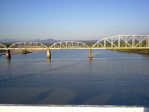
 Sunset over the Lempa river | |
 Railroad Bridge (FENADESAL) over the Lempa river, as seen from the Carretera del Litoral highway bridge (El Salvador) | |
| Location | |
| Countries |
|
| Physical characteristics | |
| Source | Sierra Madre |
| • location | Olopa, Chiquimula, Guatemala |
| • coordinates | 14°41′33″N 89°18′18″W |
| • elevation | 1,200 m (3,900 ft) |
| Mouth | Pacific Ocean |
• location | El Playón, Tecoluca, San Vicente, El Salvador |
• coordinates | 13°15′17″N 88°49′38″W |
• elevation | 0 m (0 ft) |
| Length | 422 km (262 mi) |
| Basin size | 18,246 km2 (7,045 sq mi) |
| Discharge | |
| • location | Cuscatlan bridge[1] |
| • average | 362 m3/s (12,800 cu ft/s) |
Geography
Its sources are located in between the Sierra Madre and the Sierra del Merendón in southern Guatemala, near the town of Olopa.[2] In Guatemala the river is called Río Olopa and flows southwards for 30.4 kilometres (18.9 mi) before entering Honduras and changing its name to Lempa river at 14.547700°N 89.264002°W. In Honduras it flows through Ocotepeque Department for 31.4 kilometres (19.5 mi), and crosses the border with El Salvador at the town of Citalá (14.371857°N 89.212439°W) in the department of Chalatenango. The river continues its course for another 360 kilometres (220 mi) in El Salvador, flowing in a generally southwards direction until it reaches the Pacific Ocean in the department of San Vicente.[2][3] The river forms a small part of the international boundary between El Salvador and Honduras.
The river's watershed covers 18,246 square kilometres (7,045 sq mi), of which 10,255 square kilometres (3,959 sq mi) (56 percent) is in El Salvador, 5,696 square kilometres (2,199 sq mi) in Honduras and 2,295 square kilometres (886 sq mi) in Guatemala.[1] Forty-nine percent of El Salvador's territory is covered by the Lempa river basin,[1] and 77.5 percent of the Salvadoran population lives in cities, towns, and villages that are in its basin, including the capital city of San Salvador.[3]
Hydroelectricity

There are several hydroelectric dams along the river. In El Salvador there is the Guayojo dam, the Cerrón Grande Hydroelectric Dam, the 5 de Noviembre dam, and the 15 de Septiembre dam which can be easily seen from the Pan-American highway.
See also
- List of rivers of Guatemala
- List of rivers of Honduras
- List of rivers of El Salvador
- List of rivers of the Americas by coastline
References
- "Water Resources Assessment of El Salvador" (PDF). United States Army Corps of Engineers (USACE). 1998. Archived from the original (pdf) on 2009-01-09. Retrieved 2009-05-04.
- Hernández, Walter (2005). "Nacimiento y Desarrollo del río Lempa" (pdf). San Salvador: Servicio Nacional de Estudios Territoriales (SNET). Retrieved 2009-05-03.
- "Mapas de Recursos Hídricos". San Salvador: Servicio Nacional de Estudios Territoriales (SNET). Archived from the original on April 22, 2009. Retrieved 2009-05-03.
На других языках
[de] Río Lempa
Der Río Lempa ist ein ca. 422 km langer Fluss, der im Süden des Departamento Chiquimula in Guatemala aus dem Zusammenfluss mehrerer Quellbäche in einer Höhe von ca. 1000 m entspringt, das Gemeindegebiet von Esquipulas sowie den äußersten Westen von Honduras und weite Teile von El Salvador durchfließt und schließlich in den Pazifik mündet. Er ist mit 320 km Länge der längste Fluss El Salvadors.- [en] Lempa River
[es] Río Lempa
El río Lempa es un río con vertiente al océano Pacífico. Con 422 km de longitud es uno de los ríos más largos de Centroamérica y el más largo de El Salvador. Su cuenca abarca tres países: Guatemala, Honduras y El Salvador.[ru] Лемпа (река)
Ле́мпа (исп. Río Lempa)[1] — река Центральной Америки, протекает по территории Гватемалы, Гондураса и Сальвадора. Длина реки — 422 км[2], площадь водосборного бассейна — 17900 км²[2]. Расход вводы достигает 2219 млн м³ в год[2].Другой контент может иметь иную лицензию. Перед использованием материалов сайта WikiSort.org внимательно изучите правила лицензирования конкретных элементов наполнения сайта.
WikiSort.org - проект по пересортировке и дополнению контента Википедии
