geo.wikisort.org - River
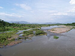
The Choluteca River (Spanish: Río Grande o Choluteca) is a river in southern Honduras. Its source is in the Department of Francisco Morazán, near Lepaterique (south-west Tegucigalpa), and from there it flows north through the city of Tegucigalpa, then south through the department of El Paraíso, and the department and city of Choluteca. The mouth of the river—located among wetland—is near the coastal town of Cedeño, on the Gulf of Fonseca.
This article needs additional citations for verification. (September 2009) |
According to FAO, the Choluteca River is 349 kilometres (217 mi) long from source to mouth. Its hydrographic basin has an area of 7,681 square kilometres (2,966 sq mi).[1] It increases its volume between May and October, together with the rainy season. Its basin is affected by severe drought together with the El Niño phenomenon, and this is usually associated with severe bush fires.
There are no dams built along the main course of the river to leave it to its natural health[citation needed].
The flooding of this river was a major source of destruction during Hurricane Mitch in 1998. It washed out entire neighborhoods in Tegucigalpa, and eventually swelled to six times its normal size in Choluteca. There it destroyed neighborhoods and part of the commercial center. Further down it also devastated the tiny Morolica, destroying the entire hamlet, requiring the town to be rebuilt three miles upriver.[2] The hurricane also rerouted the river, which was no longer flowing beneath the New Choluteca Bridge.
See also

- Rivers of Honduras
- Water Resources Management: The Choluteca river basin in Honduras
- Water Resources Management in Honduras
References
- "Honduras - Geografía y Población". FAO. 2000. Retrieved 2009-05-25.
- Anderson, John Ward (1999-04-19). "A Hero Emerges From Mitch's Devastation". Washington Post. ISSN 0190-8286. Retrieved 2021-01-08.
На других языках
[de] Río Choluteca
Der ca. 349 km lange Río Choluteca (im Oberlauf auch Río Grande oder Río San José genannt) ist der längste Fluss des mittelamerikanischen Staats Honduras.- [en] Choluteca River
[es] Río Choluteca
El río Choluteca o también nombrado Río Grande o Choluteca, atípicamente solo Río Grande en Honduras. Es un río que recorre tres departamentos al sur de Honduras. Nace en el departamento de Francisco Morazán, fluye a través del departamento de El Paraíso y concluye su recorrido en el departamento de Choluteca para desembocar en el Golfo de Fonseca al sur del país, en el Océano Pacífico. Su recorrido cruza por el municipio del Distrito Central dividiendo así a las ciudades gemelas de Comayagüela y Tegucigalpa que en conjunto conforman la capital del país.[it] Choluteca (fiume)
Il Choluteca (in spagnolo: Río Choluteca) è un corso d'acqua dell'Honduras meridionale. Attraversa la capitale honduregna Tegucigalpa.[ru] Чолутека (река)
Чолуте́ка[1] (исп. Río Choluteca[1], Río Grande o Choluteca) — река в южной части государства Гондурас; впадает в залив Фонсека Тихого океана[1] вблизи прибрежного города Седеньо.Другой контент может иметь иную лицензию. Перед использованием материалов сайта WikiSort.org внимательно изучите правила лицензирования конкретных элементов наполнения сайта.
WikiSort.org - проект по пересортировке и дополнению контента Википедии
