geo.wikisort.org - Reservoir
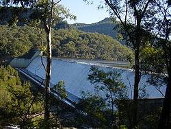
Tallowa Dam, completed in 1976, is a concrete gravity dam with central overflow spillway, located on the Shoalhaven River, downstream from the river's confluence with the Kangaroo River. The dam wall of 325 cubic metres (11,500 cu ft) is 43 metres (141 ft) high and 528 metres (1,732 ft) in length. At 100% capacity, the dam wall holds back approximately 85,500 megalitres (3,020×106 cu ft) and creates the impounded reservoir of Lake Yarrunga that has a surface area of 831 hectares (2,050 acres), drawn from a catchment area of 5,750 square kilometres (2,220 sq mi). The spillway has a discharge capacity of 27,600 cubic metres per second (970,000 cu ft/s).[2]
| Tallowa Dam | |
|---|---|
 The Tallowa Dam spillway, 2010 | |
| Country | Australia |
| Location | Shoalhaven |
| Coordinates | 34°46′11″S 150°18′30″E |
| Purpose | water supply |
| Status | Operational |
| Construction began | 1972[1] |
| Opening date | 1976 |
| Construction cost | $11,250,000 |
| Dam and spillways | |
| Type of dam | Gravity dam |
| Impounds | Shoalhaven River |
| Height | 43 m (141 ft) |
| Length | 518 m (1,699 ft) |
| Dam volume | 325 m3 (11,500 cu ft) |
| Spillways | 1 |
| Spillway type | Central overflow |
| Spillway capacity | 27,600 m3/s (970,000 cu ft/s) |
| Reservoir | |
| Creates | Lake Yarrunga |
| Total capacity | 90,000 ML (3,200×106 cu ft) |
| Catchment area | 5,750 km2 (2,220 sq mi) |
| Surface area | 831 ha (2,050 acres) |
| Website Visit Tallowa Dam at waternsw.com.au | |
The 'full operating storage' for Tallowa Dam refers only to the amount of water in the dam that is available to be transferred to Sydney and the Illawarra. When full, the dam can hold approximately 90,000 megalitres (3,200×106 cu ft). 21,800 megalitres (770×106 cu ft) is available to be transferred to the Sydney water supply.[3] Other water from Tallowa Dam is provided to Shoalhaven City Council for supply to local communities. Water is also released from the dam as environmental flows for the Shoalhaven River.[4][5]
The construction of a large barrier across the river has meant that the means of travel for fish has been completely confounded. There was no longer any means for the fish to get to their spawning areas further upstream.[6] An innovative fish lift was constructed in 2009 to allow the fish to be collected and transferred over the dam wall.
See also
- List of reservoirs and dams in Australia
References
- "New dam". The Canberra Times. Vol. 46, no. 13, 157. Australian Capital Territory, Australia. 22 June 1972. p. 1. Retrieved 15 April 2017 – via National Library of Australia.
"IN BRIEF". The Canberra Times. Vol. 46, no. 13, 176. Australian Capital Territory, Australia. 14 July 1972. p. 3. Retrieved 15 April 2017 – via National Library of Australia. - "Register of Large Dams in Australia" (Excel (requires download)). Dams information. The Australian National Committee on Large Dams Incorporated. 2010. Retrieved 3 May 2013.
- "Weekly verified storage reports". www.waternsw.com.au. Retrieved 23 January 2020.
- "Tallowa Dam". Water storage and supply report. Sydney Catchment Authority. Archived from the original on 12 May 2013. Retrieved 9 March 2013.
- "Tallowa Dam". Sydney Water. Retrieved 15 April 2017.
- "NSW aspect in dam plan". The Canberra Times. Vol. 49, no. 13, 937. Australian Capital Territory, Australia. 13 December 1974. p. 20. Retrieved 15 April 2017 – via National Library of Australia.
Further reading
- Gehrke, P. C.; Gilligan, D. M.; Barwick, M. (2002). "Changes in fish communities of the Shoalhaven River 20 years after construction of Tallowa Dam, Australia". River Research and Applications. 18 (3): 265–286. doi:10.1002/rra.669.
Другой контент может иметь иную лицензию. Перед использованием материалов сайта WikiSort.org внимательно изучите правила лицензирования конкретных элементов наполнения сайта.
WikiSort.org - проект по пересортировке и дополнению контента Википедии