 July 2002 – The sea's former bed is visible as lighter-colored areas, the lightest regions representing the most recent retreat.
 November 2003 – Much of the Eastern Sea's water has evaporated, the jade green swirls representing sediment in the shallow water.
 August 2009 – The Eastern Sea's mud flats have dried further, with only the faintest glimmer of water where it drains into the Western Sea. Barsakelmes Lake appears between the Northern and Western seas.
 July 2010 – A closeup of the channel leading from the re-flooded Eastern Sea to the Western Sea. The white areas are the exposed salt flats of the new Aralkum desert.
 August 2010 – Part of the Eastern Sea has been re-flooded by the Amu Darya from heavy snowmelt.
 September 2011 – The Northern Sea and Eastern Sea lost water, while the Western Sea gained more water.
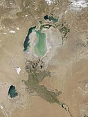
 August 2014 – The Aral Sea completely loses its Eastern Lobe.
geo.wikisort.org - Reservoir
The South Aral Sea was a lake in the basin of the former Aral Sea which formed in 1987 when that body divided in two, due to diversion of river inflow for agriculture. In 2003, the South Aral Sea itself split into eastern and western basins, the Eastern Sea and the West Aral Sea, connected by a narrow channel (channel bed at an elevation of 29 m (95 ft)) that balanced surface levels but did not allow mixing, and in 2005 the North Aral Sea was dammed to prevent the collapse of its fisheries, cutting off the only remaining inflow to the southern lakes. In 2008, the Eastern Sea split again, and in May 2009 had almost completely dried out, leaving only the small permanent Barsakelmes Lake between the Northern and Western Seas and increasing the expanse of the Aralkum desert.[2][3] In 2010, it was partially filled again by meltwater,[4] and by 2014 was once again dry. The West Aral Sea has some replenishment from groundwater in the northwest,[5] and so is likely to avoid desiccation.
| South Aral Sea | |
|---|---|
 The Aral Sea in mid-August 2014. The two remaining lakes to the south and west are the remains of the South Aral Sea. | |
 South Aral Sea  South Aral Sea | |
| Location | Kazakhstan–Uzbekistan, Central Asia |
| Coordinates | 45°N 58.5°E |
| Type | endorheic, natural lake |
| Primary inflows | groundwater only (previously the Amu Darya) |
| Basin countries | Kazakhstan, Uzbekistan |
| Surface area | West Aral Sea: 3,500 km2 (1,350 sq mi) (2005) (fluctuating area of Eastern Sea) 42,100 km2 (16,250 sq mi) (1989) |
| Average depth | 14–15 m (46–49 ft) (2005) |
| Max. depth | 37–40 m (121–131 ft) (2005) |
| Surface elevation | 29 m (95 ft) (2007) |
| References | [1] |
Background
The Aral Sea began shrinking in the 1960s, when the Soviet Union decided that the two rivers feeding it, the Amu Darya and the Syr Darya, would be diverted in order to irrigate cotton and food crops in Kazakhstan and Uzbekistan. In 1987, due to an accelerated loss of water, the Aral Sea was split into northern and southern parts; the northern part is the current North Aral Sea.
Salinity
In 2007, the western basin had a salinity of 70 g/L and the eastern basin 100 g/L. Once the water level falls below the connecting channel (elevation 29 m), the salinities can be expected to diverge further. Under current conditions, the eastern basin may receive water from the Amu Darya in wet years, fluctuating in salinity and flooding an area of up to 4500 km2 in salt water to a depth of about one meter, which would preclude any economic activity in the area, while the western basin becomes increasingly saline.[6] Water diversion from the Amu Darya directly to the deeper western basin could lower its salinity enough to allow resumption of local fisheries, while allowing the eastern basin to desiccate almost entirely and avoiding the problems of flooding.[7]
Current situation
The West Aral Sea is expected to stabilize at 2,700–3,500 km2 (1,040–1,350 sq mi), a mean depth of 14–15 m (46–49 ft), and a maximum depth of 37–40 m (121–131 ft), assuming groundwater discharge at the rate of 2 km3 (0.5 cu mi) per year.[6] The Eastern Sea dried up completely in the summer of 2009, apart from the small permanent Barsakelmes Lake (between the Northern and Western seas), but it received some water from snow melt in the spring of 2010. It is expected to alternate between complete desiccation in the summers and the occasional flood from the Amu Darya or spillover from the dam holding back the North Aral Sea, though a second dike, begun in 2010, may reduce the incidence of the latter.


In 2015, the Western Sea was starting to split into two, as the channel that connects the central part of the sea and the small North-Eastern part was growing skinnier. (This can be seen on the 2014 picture.) Since 2018, the split has been complete.[8][9]
References
- "Seen from Space – South Aral Sea shrinking but North Aral Sea expanding". EORC. Retrieved 31 May 2017.
- Harald Frater (10 August 2009). "scinexx | Aralsee: Ostbecken ist jetzt Wüste: Satellitenaufnahmen dokumentieren dramatische Austrocknung der letzen Jahre – Wüsten, Aralsee, Desertifikation, Wasser, Bewässerung, Landschaft, Landwirtschaft, Flüsse". Scinexx.de. Retrieved 1 September 2013.
- "Freshwater Ecoregions of the World". Feow.org. 26 February 2013. Archived from the original on 19 February 2012. Retrieved 1 September 2013.
- "The Shrinking Aral Sea Recovers : Image of the Day". Earthobservatory.nasa.gov. 30 October 2010. doi:10.1111/j.1440-1770.2010.00437.x. Retrieved 1 September 2013.
{{cite journal}}: Cite journal requires|journal=(help) - Jarsjö, Jerker; Destouni, Georgia (2004). "Groundwater discharge into the Aral Sea after 1960". Journal of Marine Systems. 47 (1–4): 109–120. Bibcode:2004JMS....47..109J. doi:10.1016/j.jmarsys.2003.12.013.
- Peter O. Zavialov, 2005, Physical oceanography of the dying Aral Sea, p 112
- "The rehabilitation of the ecosystem and bioproductivity of the Aral Sea under conditions of water scarcity" (rev. August 2007)
- https://www.weforum.org/agenda/2020/02/aral-sea-lake-water-nature-human-impact/ Satellite image of 2018
- https://eurasianet.org/northern-arals-promise-stunted-by-dam-height-international-disputes Satellite image of 2020
|
На других языках
[de] Westlicher Aralsee
Der Westliche Aralsee (kasach. Батыс Арал теңізі, usbek. Gʻarb Orol dengizi, russ. Западное Аральское море) ist der westliche Teil des früheren Aralsees. Er liegt innerhalb der Aralo-Kaspischen Senke in einem Becken, dem Tiefland von Turan, zwischen dem Ustjurt-Plateau und der Wüste Aralkum. Der See gehört teils zu Kasachstan sowie teils zu Usbekistan.- [en] South Aral Sea
[fr] Grande Aral
La Grande Aral est un lac d'eau salée d'Asie centrale. C'est le reste de la moitié sud de l'ancienne mer d'Aral qui s'est en grande partie asséchée car les eaux des deux fleuves qui l'alimentaient, le Syr-Daria et l'Amou-Daria ne l'atteignent pratiquement plus à cause du développement de l'irrigation pour l'agriculture. Elle s'est formée en 1986 lorsque le niveau de la mer d'Aral avait tellement baissé que l'agrandissement de la péninsule de Kokaral a mené à la séparation de la Petite mer d'Aral au nord qui reçoit encore les eaux du Syr-Daria et de la Grande Aral au sud, qui ne reçoit des eaux de surface que lorsque les crues dues à la fonte des neiges sont particulièrement importantes. Depuis 2005, la construction de la digue de Kokaral a renforcé la séparation entre les deux Aral et l'assèchement de la Grande Aral.[it] Grande Aral
Il Grande Aral è un bacino lacustre provocato dal graduale prosciugamento del Lago d'Aral.[ru] Большое Аральское море
Большое Аральское море (Большой Арал) — система гипергалинных озёр в бассейне разделившегося Аральского моря, образовавшаяся в 1989 году в результате снижения уровня последнего. В 2001 году Большое Аральское море разделилось на восточную и западную части, соединяющиеся узкой протокой Узун-Арал, находящейся на высоте 34 м над уровнем моря[1]. Первоначальное направление течения воды — с востока на запад — после прекращения поступления амударьинских вод в озеро сменилось на противоположное[1]. Площадь западной части Большого Аральского моря держится на уровне 3500—3800 км², средняя глубина — 14—15 м, максимальная — 37—40 м[2]. Западный сегмент моря незначительно пополняется грунтовыми водами, что существенно замедляет его высыхание[3]. Подземные воды дают приток, равный в среднем 2 км³ воды в год[2]. В относительно влажные годы Восточное море частично восстанавливается, но по окончании паводков на реках быстро исчезает из-за стока воды в западную часть и испарения воды на большой площади мелководного солончака.Текст в блоке "Читать" взят с сайта "Википедия" и доступен по лицензии Creative Commons Attribution-ShareAlike; в отдельных случаях могут действовать дополнительные условия.
Другой контент может иметь иную лицензию. Перед использованием материалов сайта WikiSort.org внимательно изучите правила лицензирования конкретных элементов наполнения сайта.
Другой контент может иметь иную лицензию. Перед использованием материалов сайта WikiSort.org внимательно изучите правила лицензирования конкретных элементов наполнения сайта.
2019-2025
WikiSort.org - проект по пересортировке и дополнению контента Википедии
WikiSort.org - проект по пересортировке и дополнению контента Википедии