geo.wikisort.org - Reservoir
Lake Markakol (Kazakh: Марқакөл, Marqaköl; Russian: озеро Маркаколь, ozero Markakol') is a lake and popular tourist destination in East Kazakhstan. The lake is fed with small rivers and streams. Its coasts are cut up by gulfs. It is the largest lake in the Katonkaragay District of East Kazakhstan Region. Its main outflow is the Kalzhyr, a tributary of the Irtysh. There have been more than 700 species of higher plants recorded in this area.[1]
This article needs additional citations for verification. (May 2011) |
This article may be expanded with text translated from the corresponding article in Russian. (August 2012) Click [show] for important translation instructions.
|
| Lake Markakol Марқакөл | |
|---|---|
 | |
 Lake Markakol Марқакөл  Lake Markakol Марқакөл | |
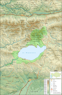 Map of the area | |
| Coordinates | 48°45′N 85°45′E |
| Primary outflows | Kalzhyr |
| Basin countries | Kazakhstan |
| Max. length | 19 km (12 mi) |
| Max. width | 38 km (24 mi) |
| Surface area | 455 km2 (176 sq mi) |
| Average depth | 14 m (46 ft) |
| Max. depth | 30 m (98 ft) |
| Shore length1 | ~ 100 km (62 mi) |
| Surface elevation | 1,447 m (4,747 ft) |
| 1 Shore length is not a well-defined measure. | |
Gallery
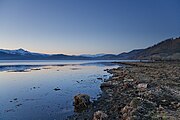

 The village of Urunkhayka on the east coast of Markakol.


References
- "BirdLife Data Zone". datazone.birdlife.org. Retrieved 2021-09-27.
Capital: Oskemen | ||
| Districts |
|  |
| Cities of regional subordination |
| |
| Major cities |
| |
| Nuclear test sites |
| |
|
Authority control | |
|---|---|
| General |
|
| National libraries | |
This Kazakhstan location article is a stub. You can help Wikipedia by expanding it. |
На других языках
[de] Markakol
Der Markakol (kasachisch Маркаколь көлі; russisch озеро Маркаколь) ist ein See im Gebiet Ostkasachstan in Kasachstan.- [en] Lake Markakol
[fr] Lac Markakol
Le lac Markakol (en kazakh : Марқакөл, Marqaköl ; en russe : Маркаколь, Markakol′) est un lac du Kazakhstan. Il est situé à l'est du pays, dans la région de l'Altaï (Kazakhstan-Oriental), près de la frontière avec la Russie et la Chine. Il est alimenté par de nombreuses petites rivières et ruisseaux.[ru] Маркаколь
Маркако́ль (каз. Марқакөл (Marqakól)) — озеро в Восточном Казахстане.Текст в блоке "Читать" взят с сайта "Википедия" и доступен по лицензии Creative Commons Attribution-ShareAlike; в отдельных случаях могут действовать дополнительные условия.
Другой контент может иметь иную лицензию. Перед использованием материалов сайта WikiSort.org внимательно изучите правила лицензирования конкретных элементов наполнения сайта.
Другой контент может иметь иную лицензию. Перед использованием материалов сайта WikiSort.org внимательно изучите правила лицензирования конкретных элементов наполнения сайта.
2019-2025
WikiSort.org - проект по пересортировке и дополнению контента Википедии
WikiSort.org - проект по пересортировке и дополнению контента Википедии