geo.wikisort.org - Reservoir
This is a list of current and former locks and dams of the Upper Mississippi River which ends at the Mississippi River's confluence with the Ohio River at Cairo, Illinois.
This transport-related list is incomplete; you can help by adding missing items. (August 2008) |
 |
 |
Locks and dams
| Name | Location | Miles above the Ohio | Coordinates | Pool elevation | Notes |
|---|---|---|---|---|---|
Minnesota | |||||
| Lake Itasca Stepping Stones / Dam | Itasca State Park | 47°14′23.2″N 95°12′27.6″W | Lake Itasca 1,475 feet |
Stepping stones placed by CCC with creation of new channel / outlet for Mississippi | |
| Vekin's Dam | 8 miles north of Lake Itasca | 47°17′59.8″N 95°14′30.0″W | n/a | Wooden dam from the late 1800s[1] | |
| Ottertail Power Co. Dam | 7 miles east of Bemidji | 47°29′1.0032″N 94°43′45.9156″W | Lake Bemidji 1,335 feet |
||
| Knutson Dam | About 15 miles (24 km) east and north of city of Cass Lake | 47°27′07″N 94°29′00″W | Cass Lake 1,301 feet |
||
| Winnibigoshish Lake Dam | About 15 miles (24 km) northwest of Deer River | 47°25′44.5″N 94°03′6.8″W | Lake Winnibigoshish 1,290 feet |
Owned/operated by U.S. Army Corps of Engineers, Mississippi Valley Division, St. Paul District | |
| Pokegama Dam | Mile 1187 | 47°15′2.9844″N 93°35′15.5184″W | Owned/operated by U.S. Army Corps of Engineers, Mississippi Valley Division, St. Paul District | ||
| Blandin Paper Co. Dam | Mile 1183.6 | 47°13′54.5628″N 93°31′52.9500″W | |||
| Potlatch Dam | Brainerd, Minnesota | 46°22′40.8324″N 94°11′0.0816″W | Rice Lake 1,174 Feet |
||
| Little Falls Dam | Little Falls, Minnesota | 45°58′32″N 94°22′06″W | |||
| Blanchard Dam | Royalton, Minnesota | 45°51′39″N 94°21′36″W | |||
| Sartell Dam | Sartell, Minnesota | 45°37′15″N 94°12′13″W | |||
| St. Cloud Dam | St. Cloud, Minnesota | 45°32′52″N 94°08′50″W | |||
| Coon Rapids Dam | Brooklyn Park / Coon Rapids, Minnesota | 45°08′36″N 93°18′43″W | No locks, ends navigable portion of river | ||
| Upper Saint Anthony Falls Lock and Dam | Minneapolis, Minnesota | ~854 | 44°58′54″N 93°15′31″W | 799 feet | Last lock upstream on river. Since June 9, 2015, the lock has remained closed to prevent the spread of invasive Asian Carp.[2] Located within the Mississippi National River and Recreation Area. |
| Lower Saint Anthony Falls Lock and Dam | Minneapolis, Minnesota | ~853 | 44°58′42″N 93°14′49″W | 750 feet | Owned/operated by U.S. Army Corps of Engineers, Mississippi Valley Division, St. Paul District |
| Meeker Island Lock and Dam (demolished) |
Minneapolis, Minnesota / St. Paul, Minnesota | ~850 | 44°57′14″N 93°12′28″W | NA | Demolished. Originally known as Lock and Dam No. 2 |
| Lock and Dam No. 1 | Minneapolis, Minnesota / St. Paul, Minnesota | ~847.8 | 44°54′55″N 93°12′02″W | 725 feet | Ford Plant Powerhouse on east side. Owned/operated by U.S. Army Corps of Engineers, Mississippi Valley Division, St. Paul District |
| Lock and Dam No. 2 | Hastings, Minnesota | ~815 | 44°45′35″N 92°52′07″W | 687 feet | Owned/operated by U.S. Army Corps of Engineers, Mississippi Valley Division, St. Paul District |
Minnesota–Wisconsin | |||||
| Lock and Dam No. 3 | Red Wing, Minnesota | 796.9 | 44°36′36″N 92°36′37″W | 675 feet | Owned/operated by U.S. Army Corps of Engineers, Mississippi Valley Division, St. Paul District |
| Lock and Dam No. 4 | Alma, Wisconsin | ~753 | 44°19′32″N 91°55′13″W | 667 feet | The lock is on the Wisconsin side right next to a small cafe. Owned/operated by U.S. Army Corps of Engineers, Mississippi Valley Division, St. Paul District |
| Lock and Dam No. 5 | Winona County, Minnesota | ~738.1 | 44°09′40″N 91°48′39″W | 660 feet | Visitor parking next to the lock. Owned/operated by U.S. Army Corps of Engineers, Mississippi Valley Division, St. Paul District |
| Lock and Dam No. 5A | Goodview, Minnesota | ~728.5 | 44°05′18″N 91°40′08″W | 651 feet | Owned/operated by U.S. Army Corps of Engineers, Mississippi Valley Division, St. Paul District |
| Lock and Dam No. 6 | Trempealeau, Wisconsin | ~714.1 | 43°59′59″N 91°26′18″W | 646 feet | Owned/operated by U.S. Army Corps of Engineers, Mississippi Valley Division, St. Paul District |
| Lock and Dam No. 7 | La Crescent, Minnesota | ~702.5 | 43°52′01″N 91°18′26″W | 639 feet | Adjacent to I-90 Mississippi River Bridge. Visitor parking and information next to the lock. Owned/operated by U.S. Army Corps of Engineers, Mississippi Valley Division, St. Paul District |
| Lock and Dam No. 8 | Genoa, Wisconsin | ~679.2 | 43°34′12″N 91°13′54″W | 631 feet | Visitor parking right next to the lock. Owned/operated by U.S. Army Corps of Engineers, Mississippi Valley Division, St. Paul District |
Iowa–Wisconsin | |||||
| Lock and Dam No. 9 | Harpers Ferry, Iowa | ~647.9 | 43°12′46″N 91°06′15″W | 620 feet | Parking area next to lock on Wisconsin side. Owned/operated by U.S. Army Corps of Engineers, Mississippi Valley Division, St. Paul District |
| Lock and Dam No. 10 | Guttenberg, Iowa | ~615.0 | 42°47′06″N 91°05′42″W | 611 feet | Owned/operated by U.S. Army Corps of Engineers, Mississippi Valley Division, St. Paul District |
| Lock and Dam No. 11 | Dubuque, Iowa | ~583 | 42°32′25″N 90°38′39″W | 603 feet | Owned/operated by U.S. Army Corps of Engineers, Mississippi Valley Division, Rock Island District |
Iowa–Illinois | |||||
| Lock and Dam No. 12 | Bellevue, Iowa | ~556.7 | 42°15′41″N 90°25′12″W | 592 feet | Owned/operated by U.S. Army Corps of Engineers, Mississippi Valley Division, Rock Island District |
| Lock and Dam No. 13 | Fulton, IL | ~522.5 | 41°53′53″N 90°09′21″W | 583 feet | Owned/operated by U.S. Army Corps of Engineers, Mississippi Valley Division, Rock Island District |
| Lock and Dam No. 14 | LeClaire, Iowa | ~493.2 | 41°34′24″N 90°23′56″W | 572 feet | Owned/operated by U.S. Army Corps of Engineers, Mississippi Valley Division, Rock Island District |
| Lock and Dam No. 15 | Rock Island, Illinois | ~482.8 | 41°31′07″N 90°34′08″W | 561 feet | Owned/operated by U.S. Army Corps of Engineers, Mississippi Valley Division, Rock Island District |
| Lock and Dam No. 16 | Muscatine, Iowa | ~457.2 | 41°25′32″N 91°0′35″W | 545 feet | Owned/operated by U.S. Army Corps of Engineers, Mississippi Valley Division, Rock Island District |
| Lock and Dam No. 17 | New Boston, Illinois | ~437 | 41°11′27″N 91°03′37″W | 536 feet | Owned/operated by U.S. Army Corps of Engineers, Mississippi Valley Division, Rock Island District |
| Lock and Dam No. 18 | Gladstone, Illinois | ~410.5 | 40°52′54″N 91°01′27″W | 528 feet | Owned/operated by U.S. Army Corps of Engineers, Mississippi Valley Division, Rock Island District |
| Lock and Dam No. 19 | Keokuk, Iowa | ~364 | 40°23′41″N 91°22′29″W | 518 feet | Owned/operated by U.S. Army Corps of Engineers, Mississippi Valley Division, Rock Island District |
Missouri–Illinois | |||||
| Lock and Dam No. 20 | Canton, Missouri | ~343 | 40°08′37″N 91°30′46″W | 480 feet | Owned/operated by U.S. Army Corps of Engineers, Mississippi Valley Division, Rock Island District |
| Lock and Dam No. 21 | Quincy, Illinois | ~324.9 | 39°54′23″N 91°25′56″W | 470 feet | Owned/operated by U.S. Army Corps of Engineers, Mississippi Valley Division, Rock Island District |
| Lock and Dam No. 22 | Saverton, Missouri | ~301.2 | 39°38′18″N 91°14′49″W | 460 feet | Owned/operated by U.S. Army Corps of Engineers, Mississippi Valley Division, Rock Island District |
| Lock and Dam No. 24 | Clarksville, Missouri | ~273.4 | 39°22′36″N 90°54′30″W | 449 feet | Owned/operated by U.S. Army Corps of Engineers, Mississippi Valley Division, St. Louis District |
| Lock and Dam No. 25 | Winfield, Missouri | ~241.4 | 39°00′17″N 90°41′11″W | 434 feet | Owned/operated by U.S. Army Corps of Engineers, Mississippi Valley Division, St. Louis District |
| Lock and Dam No. 26 (historical) | Alton, Illinois | ~202.5 | 38°53′10″N 90°10′55″W | 419 feet | Demolished, replaced by Melvin Price Locks and Dam. |
| Melvin Price Locks and Dam aka Lock and Dam No. 26 |
East Alton, Illinois | ~200.8 | 38°52′09″N 90°09′13″W | Owned/operated by U.S. Army Corps of Engineers, Mississippi Valley Division, St. Louis District | |
| Chain of Rocks Dam aka Dam No. 27 |
Glasgow Village, Missouri | ~190.2 | 38°45′27″N 90°10′39″W | 398 feet | Owned/operated by U.S. Army Corps of Engineers, Mississippi Valley Division, St. Louis District |
| Chain of Rocks Lock aka Lock No. 27 |
Granite City, Illinois | 38°42′11″N 90°10′51″W | Owned/operated by U.S. Army Corps of Engineers, Mississippi Valley Division, St. Louis District | ||
Expansion proposals for upper Mississippi locks
The Army Corps of Engineers has studied the expansion of some locks on the Upper Mississippi.[3] Since at least 1999, the Corps has considered expanding 600 ft locks 20, 21, 22, 24, and 25 to 1,200 ft.[3][4]
- Gallery
 The inland and intercoastal waterways, with the Upper Mississippi highlighted in red.
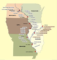
 Upper Mississippi River Stairway of Water.
 Upper Mississippi locks expansion study


See also
- List of crossings of the Upper Mississippi River
- Mississippi Valley Division
- List of locks and dams of the Ohio River
References
- Weeks, John. "Vekins Dam". Retrieved May 3, 2022.
- Sepic, Matt. "End of an era: Upper St. Anthony Falls lock closes". MPR News. Retrieved 24 June 2015.
- "Big Price - Little Benefit (The case against lock expansion on the Mississippi River)" (PDF). Nicollet Island Coalition. February 2010.
- "Lock System Expansion Proposal is Aired". Milwaukee Journal Sentinel. Associated Press. August 8, 1999.
External links
- USACE St. Paul District Locks and Dams
- Historic American Engineering Record (HAER) historical overviews:
- HAER No. MN-20, "Upper Mississippi River 9-Foot Channel Project History, Mississippi River between Minneapolis & Guttenberg, IA, Red Wing vicinity, Goodhue County, MN", 48 data pages (Lock & Dam Nos. 3–10)
- HAER No. IA-33, "Upper Mississippi River 9-Foot Channel Project, Lock & Dams 11-22, Dubuque, Dubuque County, IA", 103 data pages
- HAER No. MO-50, "Upper Mississippi River Nine-Foot Channel Project, Lock & Dam Nos. 24-27, Clarksville, Pike County, MO", 125 data pages
- HAER documentation of individual locks and dams:
- HAER No. MN-21, "Upper Mississippi River 9-Foot Channel Project, Lock & Dam No. 3, Red Wing, Goodhue County, MN", 98 photos, 11 data pages, 7 photo caption pages
- HAER No. MN-22, "Upper Mississippi River 9-Foot Channel Project, Lock & Dam No. 5, Minneiska, Winona County, MN", 92 photos, 11 data pages, 6 photo caption pages
- HAER No. MN-23, "Upper Mississippi River 9-Foot Channel Project, Lock & Dam No. 5A, Winona, Winona County, MN", 103 photos, 10 data pages, 7 photo caption pages
- HAER No. MN-24, "Upper Mississippi River 9-Foot Channel Project, Lock & Dam No. 7, Dresbach, Winona County, MN", 76 photos, 9 data pages, 5 photo caption pages
- HAER No. MN-62, "Mississippi River 9-Foot Channel, Lock & Dam No. 1, Saint Paul, Ramsey County, MN", 30 photos, 47 data pages, 3 photo caption pages
- HAER No. IA-22, "Upper Mississippi River 9-Foot Channel, Lock & Dam No. 10, Guttenberg, Clayton County, IA", 114 photos, 11 data pages, 8 photo caption pages
- HAER No. IA-23, "Mississippi River 9-Foot Channel Project, Lock & Dam No. 11, Dubuque, Dubuque County, IA", 50 photos, 16 data pages, 3 photo caption pages
- HAER No. IA-24, "Mississippi River 9-Foot Channel Project, Lock & Dam No. 12, Bellevue, Jackson County, IA", 23 photos, 14 data pages, 2 photo caption pages
- HAER No. IA-25, "Mississippi River 9-Foot Channel, Lock & Dam No. 14, Le Claire, Scott County, IA", 54 photos, 17 data pages, 4 photo caption pages
- HAER No. IA-26, "Mississippi River 9-Foot Channel Project, Lock & Dam No. 16, Muscatine, Muscatine County, IA", 21 photos, 13 data pages, 2 photo caption pages
- HAER No. IA-27, "Mississippi River 9-Foot Channel, Lock & Dam No. 19, Keokuk, Lee County, IA", 79 photos, 17 data pages, 5 photo caption pages
- HAER No. IL-26, "Mississippi River 9-Foot Channel Project, Lock & Dam No. 13, Fulton, Whiteside County, IL", 14 photos, 16 data pages, 2 photo caption pages
- HAER No. IL-27, "Mississippi River 9-Foot Channel Project, Lock & Dam No. 15, Rock Island, Rock Island County, IL", 52 photos, 16 data pages, 4 photo caption pages
- HAER No. IL-28, "Mississippi River 9-Foot Channel Project, Lock & Dam No. 17, New Boston, Mercer County, IL", 78 photos, 14 data pages, 5 photo caption pages
- HAER No. IL-29, "Mississippi River 9-Foot Channel Project, Lock & Dam No. 18, Gladstone, Henderson County, IL", 18 photos, 15 data pages, 2 photo caption pages
- HAER No. IL-30, "Mississippi River 9-Foot Channel Project, Lock & Dam No. 21, Quincy, Adams County, IL", 27 photos, 15 data pages, 2 photo caption pages
- HAER No. IL-31, "Upper Mississippi River 9-Foot Channel Project, Lock & Dam 26, Alton, Madison County, IL", 81 photos, 10 data pages, 6 photo caption pages
- HAER No. IL-32, "Upper Mississippi River 9-Foot Channel Project, Lock & Dam 26R, Alton, Madison County, IL", 59 photos, 9 data pages, 5 photo caption pages
- HAER No. IL-33, "Upper Mississippi River 9-Foot Channel Project, Lock & Dam 27, Granite City, Madison County, IL", 92 photos, 10 data pages, 7 photo caption pages
- HAER No. MO-34, "Upper Mississippi River Nine-Foot Channel Project, Lock & Dam Complex No. 20, Canton, Lewis County, MO", 33 photos, 18 data pages, 2 photo caption pages
- HAER No. MO-35, "Upper Mississippi River Nine-Foot Channel Project, Lock & Dam Complex No. 22, Saverton, Ralls County, MO", 21 photos, 15 data pages, 2 photo caption pages
- HAER No. MO-36, "Upper Mississippi River Nine-Foot Channel Project, Lock & Dam No. 24, Clarksville, Pike County, MO", 44 photos, 9 data pages, 3 photo caption pages
- HAER No. MO-37, "Upper Mississippi River Nine-Foot Channel Project, Lock & Dam No. 25, Cap au Gris, Lincoln County, MO", 93 photos, 9 data pages, 7 photo caption pages
- HAER No. WI-47, "Upper Mississippi River 9-Foot Channel, Lock & Dam No. 4, Alma, Buffalo County, WI", 118 photos, 12 data pages, 7 photo caption pages
- HAER No. WI-48, "Upper Mississippi River 9-Foot Channel, Lock & Dam No. 6, Trempealeau, Trempealeau County, WI", 79 photos, 9 data pages, 5 photo caption pages
- HAER No. WI-49, "Upper Mississippi River 9-Foot Channel, Lock & Dam No. 8, Genoa, Vernon County, WI", 120 photos, 10 data pages, 9 photo caption pages
- HAER No. WI-50, "Upper Mississippi River 9-Foot Channel, Lock & Dam No. 9, Lynxville, Crawford County, WI", 83 photos, 12 data pages, 6 photo caption pages
Текст в блоке "Читать" взят с сайта "Википедия" и доступен по лицензии Creative Commons Attribution-ShareAlike; в отдельных случаях могут действовать дополнительные условия.
Другой контент может иметь иную лицензию. Перед использованием материалов сайта WikiSort.org внимательно изучите правила лицензирования конкретных элементов наполнения сайта.
Другой контент может иметь иную лицензию. Перед использованием материалов сайта WikiSort.org внимательно изучите правила лицензирования конкретных элементов наполнения сайта.
2019-2024
WikiSort.org - проект по пересортировке и дополнению контента Википедии
WikiSort.org - проект по пересортировке и дополнению контента Википедии